This trip was well overdue - the last time I was in the Maroon Bells - Snowmass Wilderness was 7 years ago. I had picked a version of this route several years ago but never got the chance to complete it until 2 weeks ago. The ideal trek was supposed to be 6 days, but I had only 4 at my disposal, so I had to cut it short, thus skipping Lost Remuda Basin and Willow Lake.
Day 1: Maroon Snowmass Trailhead (just outside of Snowmass Vilalge) - Maroon Snowmass Trail - West Snowmass Trail - Moon Lake.
Day 2: Moon Lake - Daly Pass - Capitol Lake - Capitol Pass - Avalanche Creek - East Fork Avalanche Creek
Day 3: East Fork Avalanche Creek - Silver Creek Pass - Lead King Basin - Geneva Lake - Unnamed Lake South-West of Trail Rider Pass
Day 4: Unnamed Lake - Trail Rider Pass - Snowmass Lake - Maroon Snowmass Trail (following Snowmass Creek) - Trailhead
According to my personal calculations:
Total elevation gain over 4 days was 9,850 vertical feet. Although, the last day the vertical gain was only 700 feet, which leaves the other 3 days with an average of 3,050 vertical feet per day.
Total distance covered over 4 days was 33-35 miles. Mileage is harder to calculate, because of the numerous switchbacks on some of the trails.
I started the trip the day after Labor Day, thus avoiding the crowds during the Holiday weekend. The temperatures had been high for the last few days and the forecast was for a few more days of hot and dry weather.
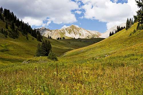
My goal was to reach Moon Lake and spend the night in its vicinity. There isn't an official trail going to Moon Lake, so I read several reports on how to get there - all of them described a route following West Snowmass Creek. That route involved quite a bit of bush whacking and route finding in the forest, which I'm not a fan of at all. By looking at the USGS map, I found a higher route that involved very little bushwhacking in the forest. When I looked on Google aerial maps, there also seemed to be a well defined trail following my route very closely. A decision was made to ditch the regular route to the lake and follow my newly discovered high route.
After following Maroon Snowmass Trail for a little over a mile, I crossed Snowmass creek and followed West Snowmass trail. The first 1/4 of a mile goes through private property and very soon I ran into a herd of cows. One of the bulls was standing right in the middle of the trail, chewing slowly and observing me. I kept going towards him, but he wouldn't move - just masticating and staring at me. When he snorted, I suddenly realized that I had an orange shirt on. Now, what if this bull was color blind and couldn't really tell red from orange? I could picture him sinking those big horns into my flesh. I quickly left the trail and took a detour, staying very close to the aspen trees. There were a few other bulls further up the trail, but those didn't look that frightening.
![Cows on West Snowmass Trail]() Rogue Cows
Rogue CowsI followed the trail to timberline and when it took a sharp turn North towards Haystack mountain, I left it, heading South. After a 1/4 of a mile of route finding and a steep climb, I came across the trail that I had seen on Google Maps. It was a very well defined trail - it looked like human built one, not just another animal trail. I stayed on it for a mile, mile and a half, up until it disappeared at the boulder field above Moon Lake.
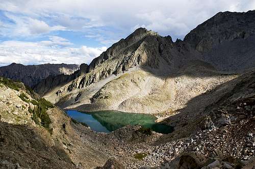
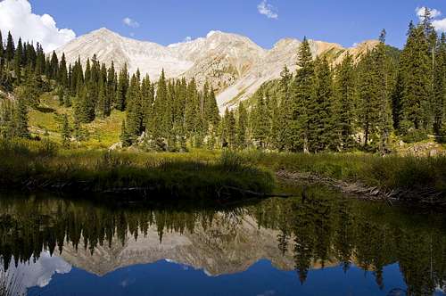
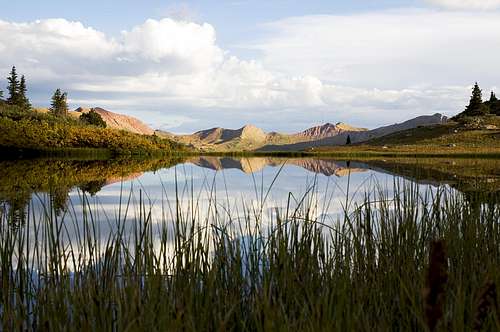
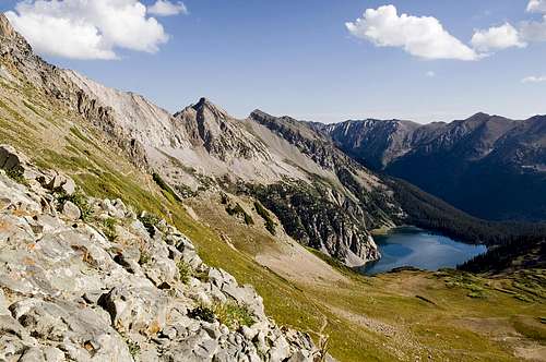
![Unnamed Lakes Below Moon Lake]() These are some unnamed lakes below Moon Lake. They seemed to offer good camping, but spending the night there was going to put me behind schedule on the following day.
These are some unnamed lakes below Moon Lake. They seemed to offer good camping, but spending the night there was going to put me behind schedule on the following day.The trail put me at 12,000 feet, a couple of hundred feet above Moon Lake. As I thought, there were no camping spots around the lake, so I spent the first night at the meadow right below Daly Pass
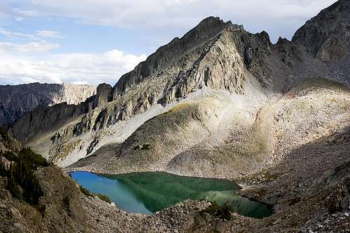
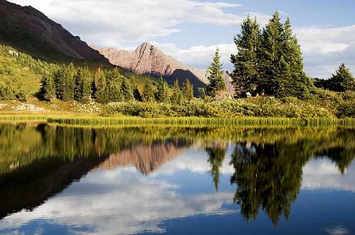
![Moon Lake]() Moon Lake
Moon Lake![Moon Lake]() Moon Lake close-up
Moon Lake close-up
I was hardly done setting up camp, when it started drizzling and then hailing. The storm that hit me was pretty intense. The hail kept coming down for 1/2 hour and after that it kept raining for an extra hour. Lightning kept striking near by again and again. I was glad that I was surrounded by high peaks, including Capitol Peak, that could take the brunt of the lightning strikes. The storm covered the meadow in white. The little stream that was running close to my tent had turned into a muddy river.
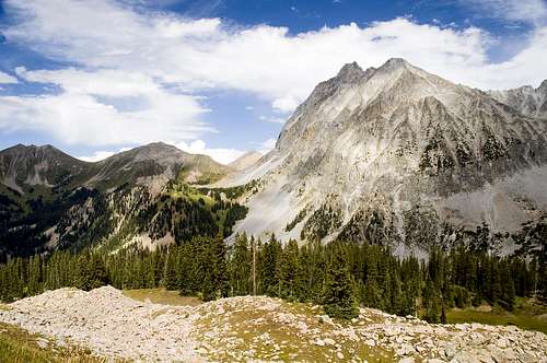
Day 2 started with a steep climb to Daly Pass (12,500 feet) - 500 vertical feet in about 1/4 of a mile. I wasn't feeling well at all, my stomach especially. I din't filter the muddy water the previous evening, so I was guessing that was the reason. It took my a little less than 40 mins to reach the pass. The view helped me forget my rumbling intestines
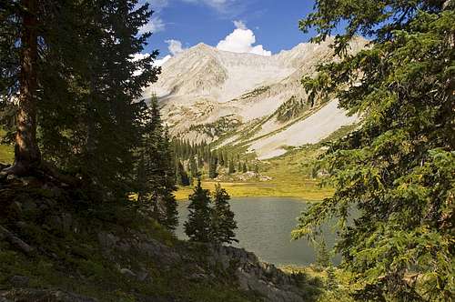
![Capitol Lake from Daly Pass]() Capitol Lake from Daly Pass - this is the standard route to climb Capitol Peak and K2
Capitol Lake from Daly Pass - this is the standard route to climb Capitol Peak and K2I followed the excellent trail down to Capitol Lake (11,580 feet). My legs felt like rubber the whole way down. Once at the lake I had a Cliff Shot (the Mocha with 50 mg caffeine) and had absolutely no problems on my next climb to Capitol Pass (12,060 feet). I guess, I just needed a little pick-me-up.
![Capitol Lake and Mount Daly]() Looking North towards Capitol Lake and Mount Daly from Capitol Pass
Looking North towards Capitol Lake and Mount Daly from Capitol Pass![Looking South from Capitol Peak]() Looking South from Capitol Pass
Looking South from Capitol Pass
I followed the trail all the way down to Avalanche Creek at 10,500 feet.
![Creek and Moss]() I filled with water at this refreshing creek.
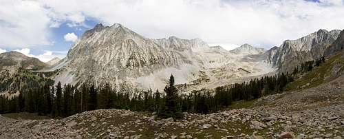
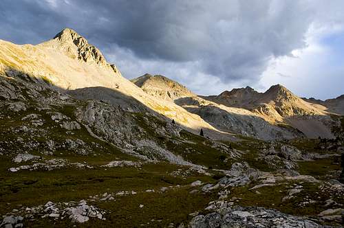
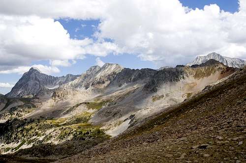
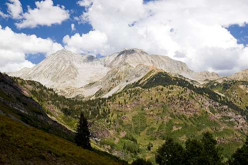
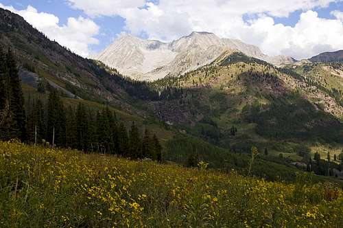
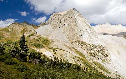
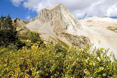
I filled with water at this refreshing creek.I stopped for 1/2 hour at a nice meadow to dry my soggy tent. I don't like carrying extra weight, even if it's only a few ounces. From Avalanche Creek, I picked up Silver Creek Trail, which led me over a ridge (11,900 feet) into one of the most beautiful basins in the whole Wilderness Area - East Fork Avalanche Creek Basin (the basin, actually, doesn't have a name, I just named it after the river that runs through it). On the way up to the ridge I stopped for almost a whole hour to eat blueberries. I found this blueberry field that was untouched. As the Beetles sing "Blueberry Fields For Ever", or it might have been "strawberry fields". I think they meant blueberry fields, but ended up with strawberry fields, because strawberries are more main stream fruit in England. Just a little bit up the trail, there was a beautiful view of Capitol Peak, rising some 3,400 vertical feet above Avalanche Lake. This is the best side of Capitol Peak - dominating the landscape for miles.
![Capitol Peak Panorama]() Capitol Peak panorama from the South.
Capitol Peak panorama from the South.![Capitol Peak from the South]() Capitol Peak from the South
Capitol Peak from the South
After the ridge, the trail stays above timberline and the elevation loss is only 400 feet.
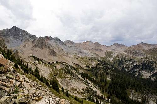
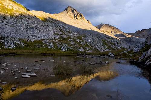
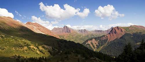
![East Fork Avalanche Creek Basin]() East Fork Avalanche Creek Basin - the trail exits the basin via Silver Creek Pass at the South end
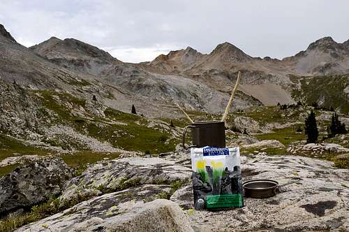
East Fork Avalanche Creek Basin - the trail exits the basin via Silver Creek Pass at the South endI fell in love with that place and decided to spend the night there. My original plan was to climb over the East ridge and drop into the neighboring basin under Snowmass Mountain and spend the night at Little Gem Lake. I found a nice tarn and set up camp. I realized that I had forgotten my titanium spork at home, so I made me 2 chop sticks. I am not fond of eating my food with sticks (there is a reason God gave us the Spoon and the Fork), even if it is Chinese or Japanese. I, deliberately, cut the chop sticks much thicker than the originals, so that I could eat my dinner faster. It still took me 1/2 hour to finish my Yakisoba. Towards the end I was just slurping it directly out of the pot.
![Dinner]() Chop sticks dinner
Chop sticks dinnerI spent the rest of the evening soaking in the views eating my sunflower seeds. No rain at all. There was some activity to the West and to the East, I could hear thunder, but nothing in my basin.
![Camp]() Camp with a view
Camp with a viewSunset turned out pretty good, also - a nice ending to a beautiful day.
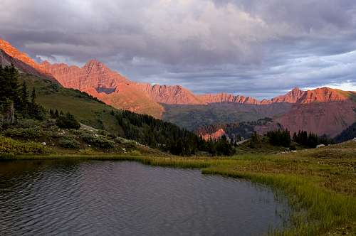
![Sunset over East Fork Avalanche Creek Basin]() Sunset over East Fork Avalanche Creek Basin
Sunset over East Fork Avalanche Creek Basin![Sunset over East Fork Avalanche Creek Basin]() Reflection in a tarn
Reflection in a tarn
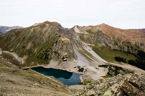
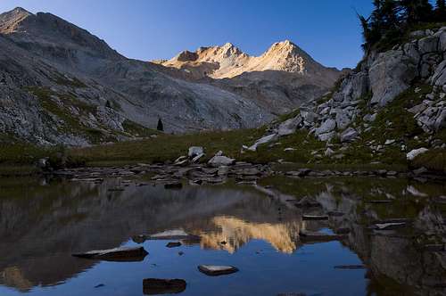
The third day started out with clear skies. I was able to snap a few shots before I headed to an unnamed lake at 12,200 feet - the only full size lake in the entire basin. This was a 1/2 mile 600 vertical feet detour that could have been avoided. The lake was just OK, I was expecting more.
![Sunrise on Mt Richie]() Sunrise on Mt Richie
Sunrise on Mt Richie ![Mt Richie and Friends]() A Panorama of Mt Richie and its neighbors on my down from the lake
A Panorama of Mt Richie and its neighbors on my down from the lake
![Meadow Mountain Reflection]() Meadow Mountain Reflection
Meadow Mountain Reflection![Meadow Mountain Reflection]() Meadow Mountain reflection - vertical shot
Meadow Mountain reflection - vertical shotI followed the trail South to Silver Creek Pass. The trail was very elusive and I lost it on several occasions. I knew exactly where I was going and was able to reconnect shortly. It doesn't seem as if this beautiful basin sees much traffic. The "4-Pass Trail" is touted as the hike to do in this Wilderness Area, although, I can boldly argue that none of those basins is as scenic as this one.
![Capitol Peak from Silver Creek Pass]() Looking back towards Capitol Peak and East Fork Avalanche Creek Basin from Silver Creek Pass
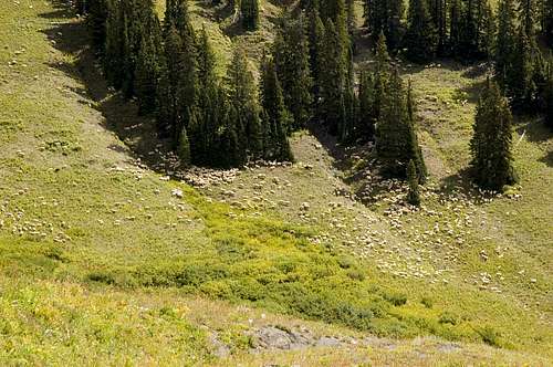
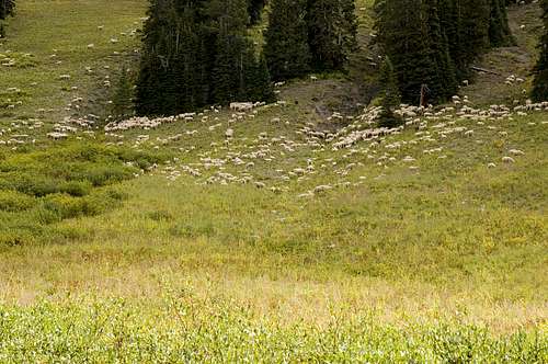
Looking back towards Capitol Peak and East Fork Avalanche Creek Basin from Silver Creek PassFrom the pass (12,250 feet), I dropped some 2,500 feet, down to 9,700 feet in the Lead King Basin. On the way down I came across a huge flock of sheep. There must have been a few hundred of them.
![Sheep Near Silver Creek]() Sheep close to the Silver Creek Trail
Sheep close to the Silver Creek Trail![Sheep Near Silver Creek]() A closer view of the sheep
A closer view of the sheep
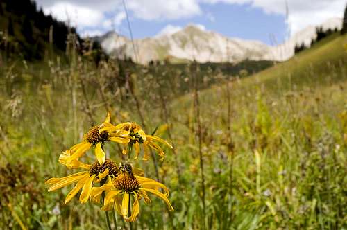
![Bee and Flowers]() A bee feasting on some wild sunflowers. Although flower season was gone, there were still some blooming flowers
A bee feasting on some wild sunflowers. Although flower season was gone, there were still some blooming flowers![Silver Creek Trail]() Looking North towards Silver Creek Pass
Looking North towards Silver Creek Pass
I spent may be 1.5 miles on some dirt road that led me to Geneva Lake trail head. The road provided expansive view of Snowmass Mountain (14,092 ft) and Hagerman Peak (13,841 ft). As I mentioned before, peaks have their photogenic side, just like people. And, for Snowmass Mountain this is it - the South-West side of it is just mesmerizing. Add Hagerman Peak to the picture and it doesn't get any better. As I'll show towards the end of this report, Snowmass Mountain, observed from Snowmass Lake, looks very unimpressive. From that angle, the skyline is being dominated by Snowmass Peak and Snowmass Mountain is just a small bump on the ridge.
![Snowmass Mountain & Hagerman Peak]() Snowmass Mountain & Hagerman Peak from the South-West
Snowmass Mountain & Hagerman Peak from the South-West![Snowmass Mountain & Hagerman Peak]() Same place with some wildflowers added to the composition
Same place with some wildflowers added to the composition
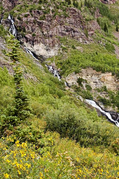
Once I got to Geneva Lake trail head I was exhausted and was starting to doubt whether I was going to be able to reach my camp site - an unnamed lake at 11,700 ft, just 3/4 mile on the South-West side of Trail Rider Pass. I had exactly 2,000 more vertical feet up and it was already 2 pm and the sun was relentlessly beating down on me. By my estimate, Geneva lake was 2 miles up and the other lake was additional 1.5 miles. The climb to Geneva Lake was steep and very exposed with little shade, which kept draining my energy. The view of Geneva Falls, though, kept pumping new juice in my veins. (The falls don't have an official name, so I named them Geneva Falls, since the river originated at Geneva Lake).
![Geneva Falls]() Geneva Falls and wild sunflowers
Geneva Falls and wild sunflowers
Right before I reached Geneva Lake, I stumbled upon a small pond and this beautiful reflection:
![Snowmass Mountain Reflection]() Snowmass Mountain reflection in a pond adjacent to Geneva Lake
Snowmass Mountain reflection in a pond adjacent to Geneva Lake
The trail circles around the lake and continues East towards the pass. There were some really nice camping spots and I would have gladly camped there if the weather wasn't cooperating.
![Snowmass Mountain and Geneva Lake]() Snowmass Mountain and Geneva Lake
Snowmass Mountain and Geneva Lake
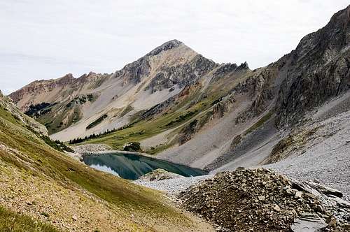
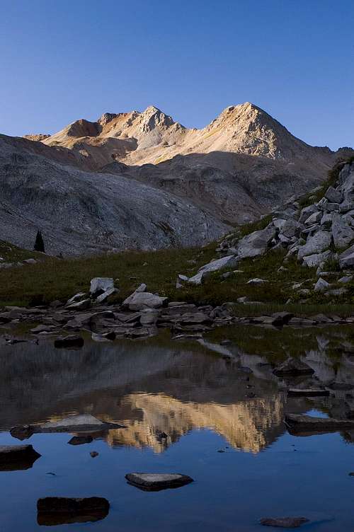
After another harrowing 1 hour I arrived at my little lake. I was exhausted and just plopped myself on the grass and enjoyed the sweeping views for 1/2 hour.
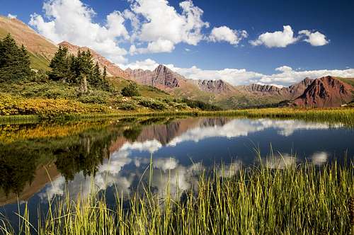
![Maroon Peak Panorama]() The view of Maroon Peak's west face was amazing
The view of Maroon Peak's west face was amazing![Maroon Peak Reflection]() Maroon Peak was 3-4 miles away and I was still able to get a reflection of it. This picture just made my day
Maroon Peak was 3-4 miles away and I was still able to get a reflection of it. This picture just made my day
The red rocks surrounding Fravert Basin in the distance made for great contrast with the blue skies and the green vegetation.
![Maroon Peak Close-up Reflection]() A close-up of Maroon Peak
A close-up of Maroon Peak![Hasley Basin Reflection]() Hasley Basin Reflection
Hasley Basin Reflection
I couldn't believe that a lake so beautiful was nameless. So, I named it "Purity Lake" - I think this name fits it perfectly, because this lake has the ability to purify ones soul. One must spend a night there to discover this.
The long day had tired me out so much that I couldn't even eat dinner. Or, may be, the thought of eating my lentil, rice & Indian spice meal with chop sticks subconsciously tightened up my stomach. Or, may be, all those sunflower seeds I ate on my 2,500 foot descent had filled me up. Any ways, I forced down a granola bar and that was my dinner.
The sunset was glorious! I have never seen such saturated red color before. There was a storm west of me and a few sun rays were able to escape the prison of the thick clouds for less than 5 minutest in order to indulge me in this amazing display of color.
![Maroon Peak and Fravert Basin at Sunset]() Maroon Peak and Fravert Basin at sunset
Maroon Peak and Fravert Basin at sunset
The fourth day began with a 700 ft climb to Trail Rider Pass (12,400 ft). From the pass it was 10 long miles and 4,000 vertical feet down to the trail head.
![Trail Rider Pass]() Looking South towards Purity Lake from Trail Rider Pass
Looking South towards Purity Lake from Trail Rider Pass![Snowmass Lake from Trail Rider Pass]() Snowmass Lake from Trail Rider Pass
Snowmass Lake from Trail Rider Pass
The upper section of the trail (above timberline) provided an intimate view of Snowmass Peak, 13,600 ft (not to be confused with Snowmass Mountain).
![Snowmass Peak]() Snowmass Peak
Snowmass Peak![Snowmass Peak]() Snowmass Peak
Snowmass Peak
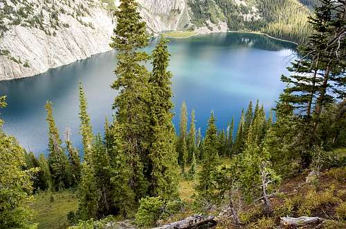
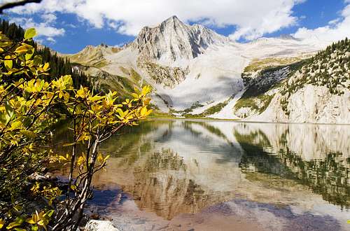
Snowmass Lake is right at the base of Snowmass Peak and is a very popular camping and fishing destination. It is a rather large lake for my taste, but very beautiful, indeed.
![Snowmass Lake]() Snowmass Lake
Snowmass Lake
Once at the shores of the lake I was greeted with this classic reflection of Snowmass Peak:
Snowmass Peak dominates the landscape from this side of the mountain and Snowmass Mountain is just a small hump on the ridge.
From the lake, the trail kept going for close to 8.5 more miles down, down, down. It was Friday, so I stumbled upon many people heading up for the weekend. The hike seemed endless. The last 2 miles caused my feet a lot of pain and I have almost deleted that memory from my brain.
The trip turned out to be a winner. I can't wait now to do the extended version to include Lost Remuda Basin and Willow Lake. May be, in another 7 years.


Comments
Post a Comment