
-
 11179 Hits
-
 86.37% Score
-
 22 Votes
|
|
Mountain/Rock |
|---|---|
|
|
46.35564°N / 7.85522°E |
|
|
Hiking, Mountaineering, Trad Climbing, Sport Climbing, Scrambling |
|
|
Spring, Summer, Fall, Winter |
|
|
9846 ft / 3001 m |
|
|
Overview
Wiwannihorn 3001 m
High above the Rhonevalley lies this wunderfull mountain, the Wiwannihorn. The Wiwannihorn is located south of the famous Bietschhorn, in the southern range of the Bernese Alps. The westridge of the mountain is connected with his neighbour the Augstkummenhörner. Both mountains offer several "plaisir climbing" routes and are frequented pretty often. This is mostly the work from the ward of the very cosy Wiwannihut. Due to the rebolting and promotion the Wiwannihorn has regain popularity in recent years. The routes are very well protected and in very solid gneis. From the 3001 meters high summit you'll have a very beautifull view towards the Pennine Alps and the Bietschhorn.
Getting There
To Ausserberg (1008m.)
By car: follow the E62 through the Rhonevalley untill you reach Visp. Take the direction Baltschieder and pass the trainstation of Visp. Cross the Rhone river and drive through the village of Baltschieder. Just follow the road untill you reach Ausserberg, 10-15 minutes from Visp.
By train: Ausserberg has a railway station on the railway line between Göppenstein and Brig. See www.sbb.ch for a schedule.
To the Wiwannihut (2470m.)
You can walk all the way from Ausserberg to the Wiwannihut, 4 hours. Fortunatly there is a road up to Fuxtritt (1851m.) where you can park your car. This way the ascent to the hut will only cost about 1 1/2 hours.
Attention: the road from Ausserberg to Fuxtritt is a toll road! Get a ticket at one of the restaurants in Ausserberg or at the last parking area in the village.
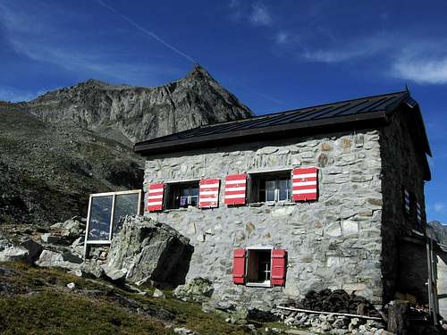
Wiwannihut (2470m.)
Usually the hut is staffed from the beginning of June to the middle of October. Check the excellent website for rescent updates: www.wiwanni.ch
30 places
Ward: Egon Feller and Regula Feller
Phone: +41 (0)27 946 74 78
Email: info@wiwanni.ch
Coordinates of the hut: 632 580 / 132 660
Routes
Normal route:
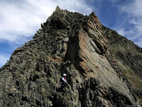
The normal route of the Wiwannihorn leads through the southface of the mountain.
Ascent: From the path behind the hut up the first hill (northwestern direction). Follow this in the direction of the foot of the Wiwannihorn south face, at the end some scrambling. The start of the route is marked (45 minutes from the hut). The route offers some climbing passages (2b max.) and contains blue bolts! After the steep part follow the summit slopes to the left to reach the summit(2-3 hours from the hut to the summit).
Descent: it is adviced to descent along the very well marked westridge (2b max.). Descent along the ridge untill you reach the pass between the Wiwannihorn and the Augstkummenhörner. From the pass you'll have to rappel two times 20 meters. After the rappels it is a short scramble to reach the path that leads to the hut (2 hours from the summit to the hut).
Other routes: (see www.wiwanni.ch for more info!)
| Route | Description |
|---|---|
| Ratatui | 2 pitches, 4b |
| Gemstritt | 7 pitches, 4b |
| Steinadler | 13 pitches, 5a |
| East-ridge | 17 pitches, 5a |


Maps and Guidebooks
Maps:
1:50.000 Landeskarte der Schweiz: Nr. 274 Visp
1:25.000 Landeskarte der Schweiz: Nr. 1288 Raron
Guidebooks:
1. Kletterführer Wiwanni, Mountaineering and Skitouring Informations in the Wiwanni Region. Edition 2005. Format A6, 32 Pages. Obtainable at the hut.
2. Plaisir West, Jürg von Känel, Edition 2004, 312 pages, ISBN 3-906087-19-0
External Links
Digital map - www.mapplus.ch
Wiwanni hut - www.wiwanni.ch
Weather forecast - www.meteoschweiz.ch
Time schedule train/bus - www.sbb.ch