
|
|
Mountain/Rock |
|---|---|
|
|
39.96840°N / 107.2399°W |
|
|
Garfield |
|
|
Hiking, Mountaineering, Scrambling |
|
|
Summer |
|
|
11369 ft / 3465 m |
|
|
Overview
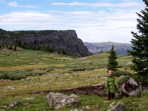
At 11,369 feet, Amphitheatre Peak is not one of the highest peaks in the Flat Tops in Colorado, but has perhaps the best views of all the peaks in the range. Amphitheatre Peak is the twenty sixth highest peak in the Flat Tops with over 300 feet prominence. The peak has awesome views and is a rather fun climb. Many lakes and ponds are visible from the summit. Though the south slopes of the mountain are gentle, the view down to Trappers Lake looks north over one of the highest cliffs in the Flat Tops.“Amphitheatre Peak” is an unofficial name. The peak overlooks and borders on the huge cirque known as the Amphitheatre and thus the name.
The Flat Tops are made of volcanic rock from an ancient eruption several million years ago. The Flat Tops are more of a huge elevated plateau rather than a typical mountain range, but the plateau has been eroded into many individual peaks and summits, and most of them are flat-topped or dome-like. The mountain area composing the Flat Tops contains hundreds of lakes full of fish, and also has some of the most extensive areas above timberline in Colorado.
Flat Tops: 11,000+ Foot Peaks with 300+ feet of Prominence
 Amphitheatre Peak as viewed from the northwest on August 18 2007.
Getting There
There are four main ways to reach the trailhead. I have only driven to two of them. The trailhead is near Trappers Lake.There is a road from the west and Meeker, one from the east and Yampa or Phippsburg, one from the northeast and Oak Creek, one from the north and Hayden, and one from the northeast and Pagoda (village) and Hamilton. I know only the roads from Hamilton and Pagoda, but very few Coloradoans will be coming from that direction (Craig), so it seems rather pointless to describe the drive in detail. Most people will be driving in from the Meeker or Yampa areas. After Pagoda or not far past Buford, all roads are gravel and in good condition in summer.
From Meeker:
From just north of Meeker and along Highway 13, turn east on County Road 8. Follow County Road 8 to Buford. Follow the road another 17 miles and turn right (south) on FS Road 205 to the Trappers Lake Lodge. There are several roads here, but they are well marked. Follow the road (FR 209) marked for the Wall Lake Trailhead and Park there.
From Yampa or Oak Creek:
I haven’t come in this way, so directions will be brief. Use a map. Briefly put you can reach country road 8 (see above) from either CR 25 from Oak Creek or CR 21 from Yampa. From there, you follow the road all the way over Ripple Creek Pass and down to FR 205. Turn left and follow the directions above.
From Hayden:
I haven’t come in this way, so directions will be brief. Use a map. Briefly put you take CR 53 south to CR 29. Turn left (east) and follow CR 29 to CR 55. Turn right (south) and follow the road to the junction with CR 8. Take CR 8 over Ripple Creek Pass and follow the route above.
From Hamilton:
Unless you live in Craig, few Coloradoans will use this route and thus the directions won’t be detailed. From Hamilton (13 miles south of Craig and along Highway 13), drive east on Highway 317 to Pagoda. Highway 13 turns into county road 29. Turn right on CR 55 and follow the remaining directions from the route from Hayden.
 Wall Lake and Amphitheatre Peak as viewed from the Southeast. The south slopes of Ampitheatre Peak are gentle, but the north side is a huge cliff.
Routes Overview
There are several routes available, but the north side forms a huge and crumbly cliff. All practical approaches are from the south.The most logical route is via Trappers Lake and the Wall Lake Trail and then the south slopes. It is a highly scenic route and is eight miles round trip. The route climbs high on the Wall Lake Trail and then follows the gentle class 2 slopes to the summit of Ampitheatre Peak. The route can be extended to several other destinations as well. See the Route Page for more details.
You can also reach the south slope of the peak via numerous routes and trails from the east and south. A great loop would be to go up the Wall Lake Trail, climb the peak, hike to Wall Lake, and take the trails east before descending Fraser Creek back to Trappers Lake.
 Amphitheatre Peak as viewed from the southeast. August 18 2007.
Red Tape
No permits are required. Wilderness regulations apply.Camping
There are many campgrounds in the area and at Trappers Lake. On summer and holiday weekends, they are crowded. In the backcountry there are many campsites all of which are between the junction of the Oyster Lake and Wall Lake Trails and Wall Lake. Wall Lake has some nice campsites, but make sure to camp at least 100 feet from the lake.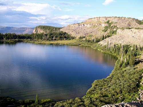 Wall Lake has some nice campsites.
When to Climb
The peak could be climbed year-round, but most of the roads to are only open only from around Memorial Day or early June to sometime in November, so outside this time period, this would probably be a very long trip unless you had a snowmobile.Mid August to mid September is good because the mosquitoes are gone. This place is mosquito heaven in late June and to mid July.
The Flat Tops (especially the northern and western section) receive much snow, so despite the lower altitude than the 14'ers, the peaks remain buried in snow until mid-July. Snowshoes are recommended in June. The Flat Tops have many mosquitoes in July, and sometimes into early August. From September and into December is hunting season, so wear blaze orange and use extreme caution. On the plus side, hunter traffic usually keeps the Ripple Creek Pass road open until around Thanksgiving weekend. Late November might be the best time to make a “winter” ascent because after the road closed, this would be very long trip.
 Amphitheatre Peak from the northwest. True summit is the left point. August 18 2007.
Mountain Conditions
CLICK HERE FOR WEATHER FORECAST OF THE AREAWeather and climate data for Marvine Ranch at 7800 feet elevation is below. *National Weather Service Data 1972-1998. Expect much wetter conditions at higher elevations. The area around Amphitheatre Peak will average around 10-15 degrees colder in the daytime than Marvine Ranch; nighttime temperatures won't have as big of a difference.
| MONTH | AVE HIGH | AVE LOW | REC HIGH | REC LOW | AVE PRECIP (in) |
| JAN | 33 | 1 | 59 | -38 | 2.43 |
| FEB | 36 | 3 | 56 | -42 | 2.30 |
| MAR | 42 | 11 | 63 | -32 | 2.55 |
| APR | 49 | 18 | 75 | -16 | 2.20 |
| MAY | 61 | 27 | 78 | 5 | 2.41 |
| JUN | 72 | 33 | 92 | 15 | 1.57 |
| JUL | 77 | 38 | 89 | 23 | 1.94 |
| AUG | 75 | 38 | 90 | 21 | 1.91 |
| SEP | 68 | 31 | 87 | 11 | 2.16 |
| OCT | 57 | 22 | 76 | -10 | 2.16 |
| NOV | 40 | 11 | 65 | -30 | 2.26 |
| DEC | 33 | 2 | 63 | -44 | 2.53 |