
-
 17852 Hits
-
 86.37% Score
-
 22 Votes
|
|
Mountain/Rock |
|---|---|
|
|
39.99000°N / 107.048°W |
|
|
Hiking |
|
|
Summer, Fall |
|
|
12172 ft / 3710 m |
|
|
Flat Tops Wilderness
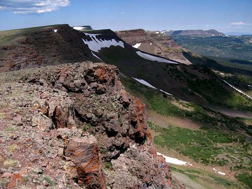 The eastern escarpment of the Flat Tops from Dome Peak's summit. Flat Top Mountain and Orno Peak are in the distance.
The Flat Tops Wilderness of Colorado is the second largest wilderness in the state at 235,035 acres. It is a distinct region of breathtaking beauty that encompasses the high alpine portion of the White River Plateau. In contrast to the ussual folded anticlines or lifted fault block mountain ranges that compose the majority of Colorado's Rocky Mountains, the Flat Tops are a vast plateau capped by a succession of thick stratified layers of basalt sitting on top of softer Mesozoic and Paleozoic sedimentary formations (notably the basalt caps layers of limestone riddled with caves). This basalt was likely the result of a local shield volcano that produced lava flows in periods between 20-25 million years ago, and then again 8-11 million years ago (Reference:USGS). This resitant cap rock protected the underlying layers as the entire region was hoisted skyward during the Laramide Orogeny. Erosion has since reduced the plateau to an average elevation of 11,600 ft. Glaciation and erosion finished the masterpiece of the Flat Tops by gouging deep basins out of the plateau leaving the region riven with glacial valleys surounded by 600 to 1,000 ft tall cliffs and graced with a plethora of gorgeous lakes. There are numerous summits within the Flat Tops that rise above the impossibly broad plateau. The summits represent layers that proved more resistent to the forces of erosion compared to the surounding country. Although different they are incredibly worthwhile.
Dome Peak Overview
 Dome Peak. July 4th 2007.
Dome Peak is the southern most summit of the impressive eastern escarpment of the Flat Tops. If approaching the Flat Tops from the town of Yampa, Dome Peak stands out as the appropiatly dome like summit south of Flat Top Mountain. Dome Peak is an interesting summit with vast views of wild country. It likely isn't climbed too often as the approach lacks the popular lakes (this does have an advantage, less mosquitos) found around other Flat Top summits. The southern route to Dome Peak is an interesting mix of hunter's trails and improvised use trails leading to the summit.
Technicaly Dome Peak is but a southern subsummit of Flat Top Mountain because it lacks the 300 ft. verticle seperation (there is a 250 ft. gap) but the 2.6 mile horizontal seperation makes up for it in the fashion of the Flat Tops. Dome Peaks summit offers privledged views of the eastern escarpment to the north, allowing one to look the length of a series of volcanic cliffs running from Dome Mountain, to Flat Top Mountain, to Orno Peak. To the east Derby Peak rears its mighty eastern face, and to the south Sheep Mountain dominates the scenery. The landscape here feels mythical and profound.
Getting There & Routes
 Southern Route on Dome Peak, 8-9 miles Roundtrip
Route: Southern Route on Dome Peak, 8-9 miles roundtrip.
Begin along the four-wheel drive road aproaching Dome Peak. Near its terminus there are a couple trails that branch off to the west as well as a trail that continues past the roads end. I took the one at the roads end. the trail was good at first leading out of aspen and through meadows. After reaching a fenced area whith evidence of cattle the trail splits and becomes indistinct and faint, but that just might have been my experience as their seemed to be many braided trails in the area. Dome Peak is visable along the entirety of this approach. The meadows aren't bad so bushwhacking when the trail disappears seemed to be an option. Ultimately I passed south of the summit and gained the lowest cliff band. From a point where the saddle between Dome Mountain and Dome Peak was visable I headed north past the Sandstone outcrop into the obvious basin. From here to the summit was just a pleasant easy stroll. From the saddle walk along the eastern cliffs to gain the broad summit.