
-
 6091 Hits
-
 82.48% Score
-
 15 Votes
|
|
Mountain/Rock |
|---|---|
|
|
42.78781°N / 102.9743°W |
|
|
Dawes |
|
|
Hiking |
|
|
4085 ft / 1245 m |
|
|
Overview
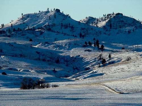 Winter snows blanket the north slopes of Aristocrat Peak
Aristocrat Peak is a prominent part of the skyline southeast of Chadron, Nebraska. At 4,085 feet, it sits almost 800 feet higher than the town of Chadron, 3,297 feet, nearly 3 miles to the northwest of Aristocrat. A twin peak lies just southwest of Aristocrat, making for a rather unique look among the peaks, buttes, ridges and hills of the Pine Ridge. Early settlers in the White River valley often referred to this landmark as "The Old Aristocrat".
 Cactus Flower on Aristocrat
Up until 2006, Aristocrat Peak was home to substantial growth of ponderosa pine forest. The major fires of 2006 that swept through the Pine Ridge, destroyed much of that forest. Much of what was left was destroyed in the 2010 Aristocrat Fire. Still, the peak is accessible to the public, and offers sweeping panoramic views in all directions. Because of the loss of forestation, less wildlife is seen on the peak, but it still sees migrating deer, pronghorns, and elk. The herds of bighorns that reside in the Pine Ridge may be seen by a lucky hiker probably not more than once or twice a year. There is a cave near the summit, just about the right size for any of the mountain lions that live in the area, and the rocky southern slope would favor sunning rattlesnakes on cool days. Reasonable caution is warranted for those who venture up the slopes of Aristocrat. A rocky "chimney" is the true high point of the peak. But, because of the nature of the soft stone and soil, great caution is important for any who would climb to the top of it.
Getting There & Route Information
 Aristocrat Peak Map
Your access to Aristocrat Peak will be influenced by how well your vehicle can handle very rough roads and/or how much you want to hike. Even though Aristocrat is on public land and just 3 miles from Chadron, direct access from town is not possible, due to restrictions by the owners of the private land in between.
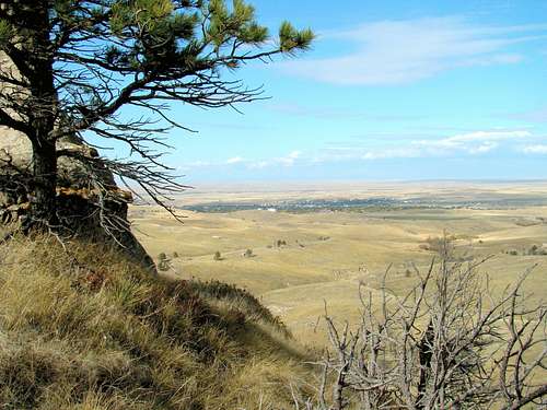 Summit View Toward Chadron
Aristocrat Peak is accessible from Chadron by driving 5 miles south on Highway 385 from the junction with Highway 20. Turn east on King Canyon Road and drive 1/2 mile east to the junction with Road 733, which also is known as Spotted Tail Road. At that junction it is a 6-mile hike (one-way) to the base of Aristocrat. There is parking there, or if you prefer a shorter hike you may drive on for 2.8 miles to the junction with Road 718. Road 733 is pretty rough, so high clearance transportation is essential. At Road 718, you can park anywhere that will not obstruct other traffic (very rare, as you will see). The hike to peak is 3.2 miles. You can attempt to drive that distance, but be forewarned the road is VERY rough and high clearance 4-wheel drive is a must. Even then, there are times you may find a fallen tree across the road at a location where you cannot just drive around. Hikers are also reminded to be sure to close the livestock gates each time they go through. There are no trails to the summit, so you will have to bushwhack up. Most of the trees are gone, giving climbers a pretty clear view of their objective above. Aristocrat Peak lies in the Chadron East Quad. The best maps for the area are available at the forest service office in Chadron, including a free motor vehicle use map for the region.
Red Tape
Since the peak lies on public lands, there is no red tape other than observing camping regulations and state firearms laws. Area law enforcement will pay particular attention to any violations of campfire restrictions, since forest fires have decimated many parts of the Nebraska National Forest.
When to Climb
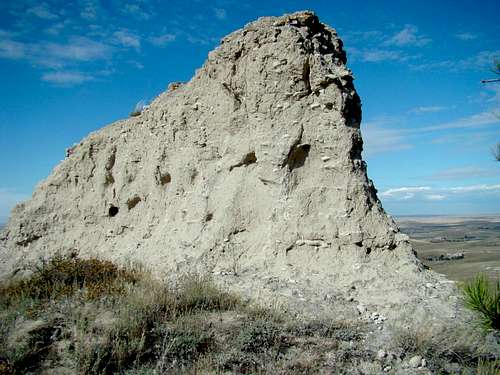 The True High Point on Aristocrat Peak
You may access this area any time of the year. Fall and spring hunting seasons discourage some non-hunters from venturing this way. If you choose to hike here during hunting seasons, please wear plenty of bright orange. For more information on Nebraska hunting and seasons, click on the link below: Nebraska Hunting Seasons & Information
 Summit Geodetic Marker
There is absolutely no road maintenance in the winters, so if the snow is deep, you might have a very long way to hike to even get to your bushwhack start point. Periods of slow steady rain can often turn these roads into quagmires, also making access extremely difficult. Please be aware of these possibilities when you make your plans. For the latest weather forecast and conditions, click on the link below: Aristocrat Peak - Chadron Area Weather
Camping & Lodging
 Cave Near Aristocrat Summit
 Summit View East
Primitive camping is allowed on national forest land, but there are no sites along this route. The nearest campground is at Chadron State Park, 3 miles further south on Highway 385. You can reach them by phone at (308) 432-6167. You can also access their web info by clicking here: Chadron State Park You can also check with the Chadron Chamber of Commerce for the latest info on in-town camping or lodging. Their phone number is (308) 432-4401
Resource Links
Aristocrat Peak is managed by the Nebraska National Forest Office in Chadron. You can reach them by phone at: (308) 432-0300 You can also access their webpage at: Nebraska National Forest