
-
 18560 Hits
-
 92.59% Score
-
 39 Votes
|
|
Mountain/Rock |
|---|---|
|
|
61.00204°N / 149.28819°W |
|
|
Hiking, Mountaineering, Scrambling |
|
|
Spring, Summer, Fall |
|
|
5505 ft / 1678 m |
|
|
Overview
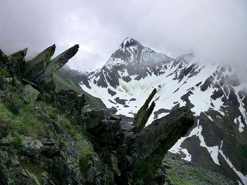 Bird Peak from the south ridge of Nest Peak, late June
Southeast of Anchorage is a forbidding, seldom explored section of Chugach State Park characterized by few trails, long, sharp ridges, and valleys of almost impenetrable lushness. Enfolded by Bird and Penguin Creeks and studded with peaks carrying bird-related names, it's sometimes referred to as the Bird Country. Reigning at the center of this region is the rocky pyramid of Bird Peak.
This is not Bird Ridge, the famous trail hike from Turnagain Arm that dozens or hundreds enjoy every summer weekend. Jungle-like undergrowth, loose scrambling, and more than a mile vertical rise make this a different kind of trip.
You're not likely to see any other people around Bird Peak. The Penguin Creek valley is popular with bears, though, and was the site of one recent mauling.
Reaching the Trailhead
The trailhead is located about 25 miles south of Anchorage along Turnagain Arm. Proceed to Mile 100.5 of the Seward Highway (Alaska Highway 1) and turn left on Konikson Road. Drive this 0.6 miles to the ample trailhead parking at its terminus. This is the same trailhead as for Penguin Peak.Standard Route (YDS class 3)
The trailhead elevation is approximately 100 feet, so you will be climbing virtually all of Bird's 5505-foot height. Indeed, with the ups and downs of the route, the total climbing on a round trip to the top of Bird Peak is between 6500 and 7000 feet--a big day by just about anyone's standard. The round-trip distance is about 16 miles, and much of it is slow going. Few will do it in under 10 hours, and a more typical up-and-back time would be 14 hours.From the trailhead, hike north on a wide, gated dirt road, staying on this past the Penguin Peak turnoff and past various ATV tracks. After about a mile you cross Penguin Creek on a vehicle bridge. Immediately bear right onto the Penguin Creek Trail, which initially is a broad ATV track. The junction is sometimes marked. Follow the ATV trail two miles to its end at about the 1000-foot elevation (bearing right at another junction). The end of the ATV trail is several hundred vertical feet above (and north of) Penguin Creek.
Directly ahead, a trail of use leads further up the slope. As of 2012 it had been badly obstructed by deadfalls, so you'll have to make some detours. This path soon emerges from the trees and begins a generally ascending traverse to the eastward across the brush and tall grass just above treeline. In early season it's pretty easy to follow; in late summer, it's massively overgrown and is no place for anyone who's not a confident routefinder.
After about three quarters of a mile, the path peters out entirely. Taking careful note of the landmarks for your return, bear diagonally up-slope and ascend through high grass and light brush about a thousand feet to a tundra bench on the indistinct ridge that forms the corner between the Penguin Creek Valley and the first side valley on its northern flank. From this bench you'll get your first view of Bird Peak itself (you're not quite seeing the true summit, but close enough).
Now descend or sidehill on very steep terrain into the hanging valley between you and Bird Peak. The valley floor is a streamside meadow of flowers and soft grass, a great place to fill those water bottles for the climb ahead.
From the valley, your objective is the crest of Bird Peak's southwest ridge in the vicinity of Point 4840. A westward spur of this ridge toes into the valley, forming a narrows that gives access to a high cirque right under the Bird Peak. Head up to or through the narrows, as the spirit moves you, and then climb the spur for 2000 feet, all the way to the crest. This looks a little improbable from below, but it goes at class 2-3. Another hour of scrambling along the frost-shattered crest of Bird's southwest ridge gets you to the summit. You'll traverse Point 4840 along the way.
There is a rough map of this route at the bottom of this page.
|
|


|
|

Other Routes
There are other methods of getting on the southwest ridge from the hanging valley. One that I've heard of people using is the snow couloir that leads from the high cirque to the col between Point 4840 and the main summit. Be aware that the top section of this couloir is steep enough to require a lot of confidence with axe and crampons, and the exit at the top can involve some rotten rock.The west ridge of Bird (from the Nest-Bird col to the top of Bird) is exposed 4th or 5th class.
The east slopes of Bird are a class 2 walk-up, but there's no easy approach to them.
Camping
The hanging valley that you traverse on the standard route up Bird has fantastic campsites. Carrying a heavy pack to that valley--over deadfalls, through high brush, and along steep, trail-less slopes--would be a lot of work.No permits are required, except for camping by large groups. Campfires are not allowed in this area of the backcountry.
There is car camping near the trailhead at Bird Creek Campground, described here.
Red Tape
The Bird Creek trailhead has a $5 parking fee if you do not have an annual Chugach State Park pass.External Links
Chugach State ParkBird Valley Trail System
Article on Bird Creek Area
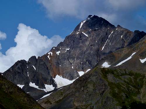
View of Bird Peak from the north (photo J. Wholey)(a rare angle, this shot taken from Camp Robber Peak; Bird is second ridge back on left)
|
|
