
-
 6112 Hits
-
 75.81% Score
-
 6 Votes
|
|
Route |
|---|---|
|
|
41.37694°N / 122.57601°W |
|
|
Hiking, Scrambling |
|
|
Spring, Summer, Fall |
|
|
Overview
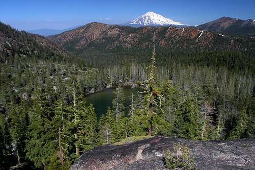 Mount Shasta and Lower Caldwell Lake
The Caldwell Lakes Trail is an alternate route to the summit of China Mountain, the fourth highest peak in the Mount Shasta region. The primary (though seldom used) route to the summit is a long ridgetop scramble that branches off of the PCT. Although boasting good views of the region, this route lacks a chance to observe China Mountain more intimately, as well as being completely devoid of water. Climbing China Mountain via the Caldwell Lakes Trail provides many excellent views in its own right, as well as the chance to pass through lush, carnivorous plant filled meadows, alongside the headwaters of Parks Creek (one of the Shasta River’s largest tributaries), past the Caldwell Lakes, and includes a scramble up the rugged cirque wall below the summit. In addition, the route is generally east and south facing, so while other routes and trails in the area may be snowbound, the trail is often clear early in the season, affording the mountain-starved a chance to get into the high country earlier. An added bonus is that the Caldwell Lakes are largely unknown and ignored, even by the local population, which means that the area furnishes one a good chance of having the lakes basin and the mountain to oneself.
Route Description
 Peak 8356 from the cliffs above Lower Caldwell Lake
The trail to the Caldwell Lakes begins 0.5 miles up a dirt road off of Forest Road 17. Although a high clearance vehicle could cover that half-mile, it is generally easier to just park off of Forest Road 17 and hike the 0.5 miles of dirt road. While roads generally make for less than desirable hiking, this is somewhat alleviated to the presence of Parks Creek, which just to the south of the road. After following the roadway at a moderate grade for 0.5 miles, the road comes to an end. This is the most confusing part of the trail to the Caldwell Lakes. At the end of the road, there is a large pile of rocks, behind which is a dirt mound. Beyond these two landmarks is a large meadow with Parks Creek coursing around its southern perimeter. About 30 yards prior to the rock pile, a trail branches off to the right and climbs above the meadow. If one misses the trail’s turnoff it is easy to still reach the trail by passing through the meadow and then climbing up the bluff on the northwest side of the meadow. Due to the abundance of carnivorous Darlingtonia, the meadow route is actually the more interesting way to go.
 Mount Shasta and Mount Eddy from the Caldwell Lakes Trail
Once on the trail, the route climbs moderately in a westerly direction. Views of Mount Shasta are good (though they improve considerably as one progresses). The trees thin out and the route is generally open. Although Parks Creek can be heard, it is no longer visible. Surprisingly, though the trail is seldom used, it is in excellent condition and easy to follow. About 0.5 miles from departing the road, the trail crosses one of the forks of Parks Creek. This fork does not originate from the Caldwell Lakes, instead coming from an extensive network of meadows in a canyon about 200 feet below Upper Caldwell Lake. After crossing the creek, the trail enters thicker forest cover and continues climbing for 0.35 miles. At this point the trail makes a discernable turn to the south and passes below a rocky cliff. If one wishes to go to Parks Creek Meadows, this is the point to depart the trail. Simply follow the creek to the meadow.
 China Mountain from Middle Caldwell Lake
The main trail continues to the south. After a short distance a cairn marks the easiest way to descend 100 feet down to Lower Caldwell Lake. The lake itself is tree-bound. The creek enters from the south and can be heard from the trail. Scrambling up the cliffs above the lake provide the best views. From here one can observe Lower Caldwell Lake, Mount Eddy and Mount Shasta, as well as much of the northern Eddy Range. Back on the trail, the route begins to climb to the west after passing Lower Caldwell Lake, coming back into proximity to Parks Creek. The creek fans out along this section of trail, coursing through numerous small channels. After following the creek briefly, the route begins to switchback through an open, rocky area. Views of Mount Shasta to the east are great. The switchbacks end as suddenly as they begin and deposit one at the mouth of Middle Caldwell Lake. The rocky cirque comes as a bit of a surprise, with stark gray cliffs climbing up to the summit of China Mountain, which is presides 1,400 feet above the basin. Small Upper Caldwell Lake is just beyond the larger middle lake. When the water level is high the distinction between the two lakes may be imperceptible.
 Looking up the route to the summit of China Mountain
To climb China Mountain, hike to the end of Upper Caldwell Lake and then head through the forest toward the large cliffs. Though they look difficult somewhat impenetrable from a distance, there are numerous routes to climb through them. One must climb 850 feet up the cliffs to reach the saddle of the knife-edge that is traversed by the scramble stemming off of the PCT. Once reaching the saddle, simply scramble another 700 feet up to the summit.
Map
 The Caldwell Lakes Trail