
-
 32710 Hits
-
 74.01% Score
-
 4 Votes
|
|
Route |
|---|---|
|
|
41.56717°N / 123.21115°W |
|
|
Hiking, Scrambling |
|
|
Spring, Summer, Fall |
|
|
Overview
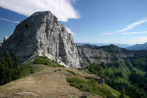
The Marble Rim
California’s Marble Mountain Wilderness offers some of the finest backcountry in the Northstate. While there are many breathtaking areas within the wilderness area, none are more popular than the Marble Rim and the Sky High Lakes. A trip combining these areas boasts beautiful lakes, lush meadows, excellent views and the opportunity to see one of the most unique mountains in the state.
The trip is not strenuous and the route connects to numerous additional trails, including the Pacific Crest Trail (PCT), so there is significant opportunity for an extended trip in the region. The biggest drawback to the journey to the Marble Rim and the Sky High Lakes is the first part of the route itself. The Canyon Creek trail is a rather unremarkable trip up Canyon Creeks canyon, under significant tree cover almost the entire way. It is four miles from the trailhead to the Marble Valley. In spite of the rather lackluster beginning to the trip, the destinations and potential side trips make this an undeniably excellent route. It can be done as a simple destination hike to either the Marble Rim or Sky High Lakes or it can be done as a lollipop, combining the Rim and the lakes as a loop.
Route Description
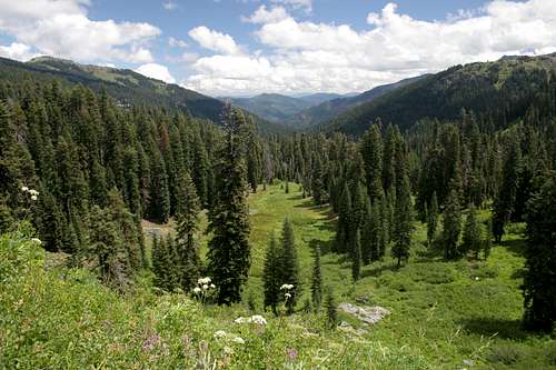
Looking down on the route through Canyon Creek
The Canyon Creek Trail begins at Lovers Camp. Even though the trial parallels Canyon Creek for most of its length, it is rarely within site of the creek, situated high above it on the slopes of the canyon. When one first sets out from the parking area, the sound of running water is actually from a piped spring that lies just north of the trail. Moving past, the sound of Canyon Creek becomes audible.
For the next four miles, the trail simply follows Canyon Creek. It remains fairly level, gaining only 600 feet in the first three miles. After 0.5 miles the route reaches a junction with the Red Valley Trail. Veer right, continuing on the Canyon Creek Trail. There are few views of either the surrounding mountains or the creek, though it continues to be audible. During these first three miles, the trail crosses 7 streams. The third, Death Valley Creek, is the most reliable source of water. The grade of the trail increases over the last mile, gaining another 600 feet. Two more streams are crossed prior to the Marble Valley. At the last creek crossing the trail finally becomes interesting, as it crosses the creek right at the point where it pours over a 40 foot waterfall. Once across the creek, the trail enters Marble Valley.
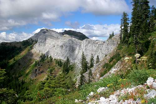
Marble Rim
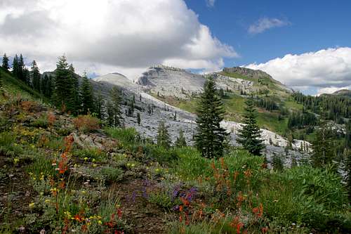
En route to the southern end of the Marble Rim
At 0.01 miles past the final creek crossing the Canyon Creek Trail intersects the trail leading to the Sky High Lakes. The trail continues to climb into the interior of the valley, catching glimpses of the Marble Rim through the trees. Eventually the route reaches a junction with the PCT near an old cabin. There are numerous options on how to proceed from his point. The most direct approach to the Marble Rim is to head north on the PCT for 0.25 miles. Turn left onto the spur trail and climb steeply up to the Marble Gap. Views of the rim are excellent from the Gap. It is possible to scramble up to the Marble Rim from this point or to traverse over towards Black Marble Mountain. The trail continues down the north side of the Marble Rim to Rainy Lake, which can be accessed from the northwestern part of the Marble Mountains.
Rather than climbing to the Marble Gap, it is feasible to ascend the Rim from the south. To achieve this, turn south on the PCT from the junction with the Canyon Creek Trail. The route passes through lush meadows and the southern tip of the massive marble cascade that flows down from the Marble Rim. After a mile from the Canyon Creek Trail the PCT intersects another trail. This is known as Four Corners Saddle. From here the PCT turns east and heads towards the Sky High Lakes. Rather than follow the PCT, to reach the Rim, turn north and begin climbing up a ridge on the Marble Rim Trail. Views are outstanding for the duration of the ascent. From here the Marble Rim trail climb north. Unfortunately the trail never actually reaches the rim itself. Instead, it turns west, skirting just below the rim. A fairly obvious use trail climbs above the Rim trail to a prominent black schist outcropping that rises above the rim. Off trail travel permits access to the Marble Rim from this point.
Sky High Lakes
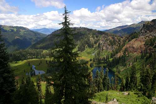
The Sky High Lakes
If the intent is to head directly to the Sky High Lakes rather than to the Marble Rim, then the most direct route to reach the lakes is to take the trail encountered 0.01 miles beyond the waterfall on the Canyon Creek Trail. From here it is 1.9 miles to Lower Sky High Lake, the first lake in the basin. The Sky High Lakes Basin is one of the prettiest in the Klamath Mountains. The three lakes, Upper and Lower Sky High and Frying Pan Lakes are cradled in luxurious meadows, surrounded by dark craggy cliffs. Such beauty has not gone unnoticed. If you had to wager a spot in the Marble Mountains where one can expect to have some company, this is it. Even so, this area receives relatively few visitors.
To reach the Marble Rim from the lakes, continue on the trail from Lower Sky High Lake, past Frying Pan Lake. The route climbs the west side of the basin, gaining 600 feet in 0.85 miles before it joins the PCT. The view of the Marble Rim from this trail junction is one of the best. Follow the PCT for 0.5 miles to the Four Corners Saddle where one meets up with the trail that leads to the south end of the Rim.
One side trip from the PCT warrants inclusion. Rather than taking to the PCT to the Rim, head east on top of the ridge above the Sky High Lakes. After a miles watch for a faint way trail branching off to the left. Follow it for 0.25 miles to small, secluded Shadow Lake. The lake is nestled high in the cliffs above the Sky High basin and from here it is possible to climb a dark tower that overlooks the entire area.
Map
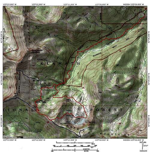 The Canyon Creek Trail to Marble Mountain and Sky High Lakes
Getting There
The Marble Rim
From Interstate 5 in Yreka take the Highway 3 exit at the south end of town. Take Highway 3 west to Fort Jones, in Scott Valley. Turn right onto River Road and proceed west, following the course of the Scott River. After several miles, turn left, crossing of the Scott River on the Indian Scotty bridge. Proceed past the Indian Scotty campground. The road narrows but remains paved, eventually coming to a dead end at the Lover’s Camp campground and trailhead complex.