Overview
Camp Creek sits in the extreme northwestern corner of Zion national Park. Its trailhead falls just outside the boundaries of the park near Kanarraville, UT, a 45 mile drive from the main part of the park in Springdale, UT.
A dry waterfall blocks direct access to the Camp Creek Valley. From trailhead, you could hike one quarter of a mile to reach the base of the dry waterfall. You will then have to return to the trailhead and follow another path up a hill and down into Camp Creek Valley. You will not find a maintained trail here but you could follow a beaten path in or near the creek. This will require bushwhacking in some places. After 2.8 miles, the creek enters a canyon that has tall red wall. You could hike the bottom of the canyon roughly two more miles to reach an area of slickrock narrows. Because of standing muddy water, I did not go into the narrows but other sources say that beyond the narrows, bushwhacking increases and the valley soon ends at the base of a cliff.
The views in Camp Creek may not be as dramatic as those in the main part of Zion National Park but if you are willing to explore a forgotten corner of the park where you are unlikely to see other hikers, Camp Creek will be the right choice for you.
![Map]() Map Map |
Getting There
A new subdivision has changed the landscape from what is described in older texts.
From St. George, UT drive less than 40 miles north on I-15 to Exit 42, Kanarraville. Turn east (right) and then almost immediately north (left) onto Old US Route 91. Follow this road less than 2 miles north until you see a subdivision. Turn east (right) onto 1925 S/Wipishani Lane and follow it a short distance through the subdivision to the end of it at a dirt road. Turn east (right) onto the well graded dirt road and go a little until the road makes a sharp left turn. This is the trailhead. There is plenty of parking space. You will not find any signs for Camp Creek. The parking area is just below a water tank up a hill. The water tank may not be seen from the parking area but it is visible from I-15 and can be used as a guide to get you to this spot.
GPS Coordinates for Trailhead: 37:30.257 North, 113:11.814 West
Camp Creek Dry Waterfall
The distance to the dry waterfall is only one quarter of a mile. At the trailhead, look south to see the fence that marks the boundary of Zion National Park. Go through the gate in the fence and follow a trail south and then east to reach the base of the dry waterfall.
Camp Creek Hike
| Place | Elevation | Distance |
| Trailhead | 5450 ft | zero miles |
| Water Tank/Gate | - | 0.60 miles |
| High Point | 5750 ft | - |
| Camp Creek | 5680 ft | 0.40 miles |
| Red Walled Canyon | 6000 ft | 1.80 miles |
| Slickrock Narrows | 6400 ft | 1.70 miles |
| Total Roundtrip | - | 9.0 miles |
At the trailhead, hike north on a dirt road at the base of the slopes to the east. I-15 can be seen across a plain to the west.
![Near Trailhead, I-15 seen]() Looking west Looking west |
You will soon see a road coming down the slopes on your right. Turn right and head south walking up the road. You will now have views of the subdivision that you drove through and where you parked.
![From the road to water tank]() From the road to water tank From the road to water tank |
The road ends at a water tank. Go through the gate in the fence marking the boundaries of Zion National Park. A beaten path will continue uphill through a forest to a high point where you can look east to see Camp Creek Valley and red colored walls at the far end of it.
![Camp Creek Valley from high point]() Camp Creek from high point Camp Creek from high point |
The path will then descend to reach Camp Creek. Make a note of this spot. On your way back, you will have to leave the creek at this spot.
![Camp Creek]() Camp Creek Camp Creek |
Head east and follow the creek. You will not find a maintained trail here but can easily hike in the creek or on its banks.
As you keep going, bushwhacking will become necessary. This actually turned out to be much more than I had expected.
![Bushwhacking]() Bushwhacking Bushwhacking |
![Bushwhacking]() Bushwhacking Bushwhacking |
![Bushwhacking]() Bushwhacking Bushwhacking |
![Bushwhacking]() Bushwhacking Bushwhacking |
![Bushwhacking]() Bushwhacking Bushwhacking |
![Bushwhacking]() Bushwhacking Bushwhacking |
![Bushwhacking]() Bushwhacking Bushwhacking |
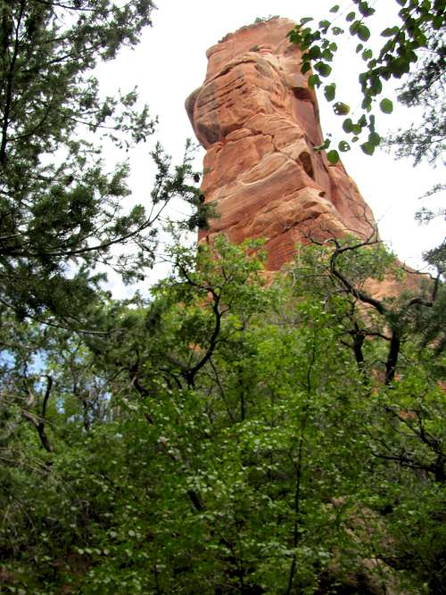
After 2.6 miles, the valley suddenly becomes narrow. From behind the bushes, you will see red rocky slopes coming down to create what looks like an entrance into a canyon.
You will then enter a canyon with red colored walls and follow the path at the bottom of the canyon.
The walls of the canyon.
Farther up an area of slickrock narrows appears. I did not go into the narrows because it had standing muddy water at the bottom of it. Other sources say that Camp Creek Canyon comes to a dead end at the base of a wall shortly beyond these narrows. My GPS coordinates also indicated that I was near the end of Camp Creek Canyon.
Essential Gear & Red Tape
Hiking equipment.
You must pay park entrance fee but there is no one at trailhead to collect. The closest fee booth is at Kolob Canyons section of the park off of I-15 at Exit 40.
No permits needed for day hikes. See link below for all rules and regulations:
http://www.nps.gov/zion/index.htm
External Links
http://www.citrusmilo.com/zionguide/campcreek.cfm.

 Map
Map

 Looking west
 From the road to water tank
 Camp Creek from high point
 Camp Creek


 Bushwhacking
 Bushwhacking
 Bushwhacking
 Bushwhacking
 Bushwhacking
 Bushwhacking
 Bushwhacking