
-
 8786 Hits
-
 87.31% Score
-
 24 Votes
|
|
Mountain/Rock |
|---|---|
|
|
46.46627°N / 13.24778°E |
|
|
Hiking, Scrambling |
|
|
Spring, Summer, Fall |
|
|
6883 ft / 2098 m |
|
|
Overview
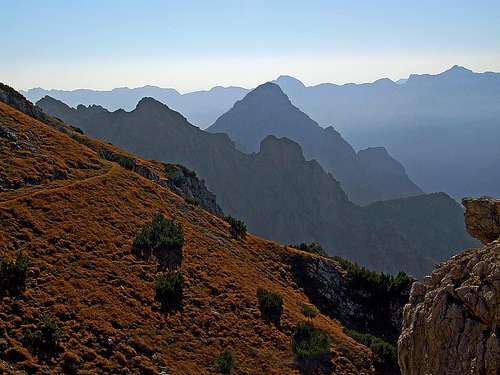
On the western slopes of Monte Chiavals

From the east

En route

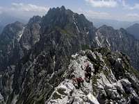
The summit
In the easternmost part, the Southern Carnic Alps (actually the central ones, because south of them there is the broad area of Carnic Pre-Alps) form a few not very high, but wild and quite broad mountain groups, are stretching in the south-north direction. One such group is the well known Monte Sernio - Creta Grauzaria group, the other one, here on SummitPost not yet described, is the group of Zuc dal Boor.
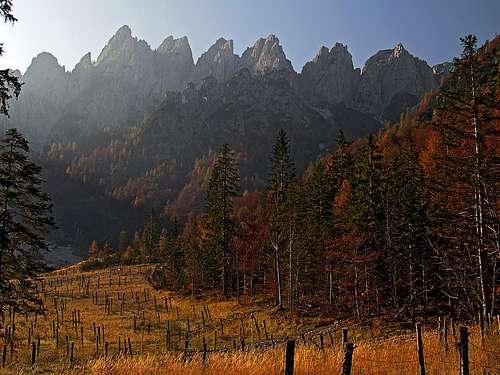
This is by all means a wonderful mountain area. A dozen of wild summits and in the centre of the group the highest one, which top 100 meters are even inaccessible without a quite serious climb. There are marked paths, yes, but the area is lonesome and in a few wild corners I believe there are still places where man hadn't set a foot. From Zuc dal Boor towards the north, for some time a compact crest runs, and only on the very north of the group it branches. There is one of the most beautiful valleys, not only in Carnic Alps. Around Gravon di Gleris (also: Vallon di Gleris), like a horseshoe a set of of wild peaks are positioned - the famous Crete di Gleris, or Sette Picche (Seven Peaks). If you are driving from Pontebba through Studena Alta and Frattis towards Sella di Cereschiatis, where the road turns down in Val Aupa, near Frattis a beautiful scenery shows for a short time. Above the alpine valley a set of wild peaks is arranged, making every tourist's hart beat stronger, stopping a car and admiring the nice scene. The central peak of those needles is the highest - Cima Alta di Gleris, 2085 m, but behind it, not seen from Gravon di Gleris valley, there is even a few meters higher Monte Chiavals, 2098 m.
Actually, Monte Chiavals is one of rare peaks in Zuc dal Boor group, which is easilly accessible - also for hikers. So, it is rising in the ridge, which connects Crete di Gleris with Zuc dal Boor, and represents the highest point of the northern part of the whole group. It is almost exclusively a mountain for hikers and scramblers. Except its 300 m tall E wall, the other faces of Monte Chiavals are not high enough and not compact enough for serious climbing. Yes, on the neighbourhood needles, climbers can find valuable goals. But those should be described separately. Monte Chiavals is a rather compact ridge mountain, with two rugged, grassy and rocky slopes: the western one and the eastern one. In some more details its geography will be described on the access routes, but the detailed description of Crete di Gleris will be left for someone who also knows ascents to its peaks (explore also the map below). The value of Monte Chiavals lies in the fine mountain scenery on the ascent - we hike and scramble over deep notches and around sharp needles, and when we reach the top, the summit panorama is also very rewarding. As in the middle of Zuc dal Boor group there's a good Bivouac G. Bianchi, a nice possibility is also the traversing of the whole Zuc dal Boor group. It can be done in two days, but the ascent on the highest point must be seriously considered if doable.
Summit Panorama
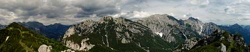
Towards the north, there is the wild world of Crete di Gleris - several rock towers, which from the highest Monte Chiavals do not look so impressive any more - they are much nicer when moving around them on lower altitudes. In the distance, behind Crete di Gleris, there are the mountains of Carnic Alps main crest and behind them the rest of Eastern Alps. The most stunning view from Monte Chiavals is towards the east. On the other side of Canal del Ferro, i.e. Fella/Bela river, there are Julian Alps. Yes, on Montaž / Jôf di Montasio we are looking just from its most beautiful side. Like a giant horn the mountain is rising more than 2000 meters above the deep Dogna/Dunja valley. A scene that one never forgets. Other mountains fall humbly in the background, even if we can distinguish them all - on one side the Malborghetto / Naborjet chain, on the other side Monte Cimone / Strma peč and behind it Kanin. The view towards the south is all dominated by Zuc dal Boor. I was not much around there, but would dare to say, that from Monte Chiavals Zuc dal Boor is seen in its best splendor. The NE wall is a true labirynth of pillars and steep ravines, it falls almost vertically some 800 meters, then in a very steep and wild slope all the way down to Fella/Bela river, which flows more than 1600 metes below the summit. Yes, altitude differences in these mountains can be very considerable. The view towards the west is less wild. Yet steep slopes are falling some 800 meters till the picturesque end of Val Alba, which can be reached by a mountain road, closed for public traffic. There's an old military ruine at the end of the valley and a few nice meadows - an attractive approach option. Beyond the side ridge of Val Alba and Aupa valley there is the group of Creta Grauzaria and Monte Sernio, the two old friends sending greetings over here. And left and right of them the rest of Carnic Alps - the more or less stand alone summits of the central part.
 Montaž group |
 Zuc dal Boor |
 Creta Grauzaria and Monte Sernio |
Getting There
You best reach the area by the Udine-Tarvisio highway. On the south, you can exit it near Gemona, on the north near Pontebba. Otherwise through Val di Ferro a very good state road is running, encircling Zuc dal Boor group by the eastern side. The best trailhead for Monte Chiavals is the parking place in Gravon di Gleris, 1120 m. You drive from Pontebba towards Val Aupa, in Frattis you deter left and drive some 2 km more till the end of the valley. After the parking lot the ramp closes the mountain road which ascends a bit higher.
The other possibility of approach is Val Alba. From Canal del Ferro you deter north and drive through Moggio Udinese in Val Aupa. But soon, near Pradis, you take a mountain road right. It takes you around the side crest and in Val Alba, but on the altitude of 1050 m it looks also closed for public traffic (Tabacco map, and web descriptions). The rest of the valley must be then done on foot.
The third options are trailheads in Val Aupa. But these approaches are long and they all reach the upper corners of Val Alba - you must cross the side crest of Val Alba.
And the last option is the "brave" straight ascent from Canal del Ferro. Between Dogna and Pietratagliatta, on the altitude of 459 m, a short mountain road deters towards the west into the valley of Rio Ponte di Muro. Doesn't matter probably how high you can get by it, you have anyway some 1650 meters of altitude to do.
And finally, as said, Zuc dal Boor group can be traversed in a multi-day trek. You mostly go by Alta Via C.A.I. Moggio (The Moggio Alpine Clibe High Trail), which connects Val Aupa on the north and Ovedasso / Moggio on the south. These are so also the possible trailheads.
Routes Overview
1. From Gravon di GlerisFrom the parking place, 1120 m, we hike southwards below the walls of Crete di Gleris and then ascend either over Forcella della Pecora, 1824 m, or Forcella della Vacca, 1789 m, on the southern side. Crossing the western slope of Cima Alta di Gleris and Monte Chiavals, we reach a small notch in the W side ridge of Monte Chiavals, after which we ascend by it steeply on top. Good 1000 m of altitude, 3 h, demanding hike-up (T4) and easy scramble.
2. From Gravon di Gleris around the E side(I haven't done the route.) From the parking place, 1120 m, we cross the river bed of Rio Gravon di Gleris towards the SE, and continue by the marked path on Forcella Alta di Ponte di Muro, 1589 m. From there by the eastern slopes of Crete di Gleris and Monte Chiavals by the paths No. 428 and No. 429 all the way to Forcella Chiavals, 1864 (I guess some ups and downs). From there from the SW side on the S ridge of Monte Chiavals and by the ridge on top. Some 1200 m of altitude, demanding hike-up (Italian grading EE - for experienced hikers), some 4 h. |


3. From Val Alba
(I haven't done the route.) From the place, where the mountain road in Val Alba is closed, 1050 m, by the road till the end of the valley (big military object ruine). From there by the unmarked path towards the NE, towards Forcella della Pecora. When the path reaches the rocks of Crete di Gleris, it turns along a shallow valley left (towards the N) and reaches ruins of an object below the overhanging wall of Cima della Vacca. There we hit the marked path No. 425 and follow it towards the SE. Like above in #1, we ascend on top. Some 1100 m of altitude, demanding hike-up, 3 h. The path in the lower part is not marked.
4. From Val Alba by the G. Bianchi bivouac
(I haven't done the route.) From the place, where the mountain road in Val Alba is closed, 1050 m, by the road till the crossroads, where left the road to Rif. Vualt goes (cca 1158 m). (The other option is, to go from the parking place directly above Rio Alba by the path No. 450.) Here by the dirt road right (towards the E), across Rio Alba, and further towards the SE by the marked path No. 428. In 2 h we reach G. Bianchi bivouac, above ex Casera Chiavals, 1725 m. From there shortly towards the N by path No. 425, then after Forcella Chiavals, 1864 m, right up on the S ridge of Monte Chiavals. By the ridge on top. Some 1100 m of altitude, demanding hike-up (Italian grading EE - for experienced hikers), 3 h.
5. From Canal del Ferro
(I haven't done the route.) We park by the main road on 459 m of altitude. By the marked path No. 428 along Rio Ponte di Muro towards the W. Where the valley and the path branches, we take the left branch (still path No. 428) and continue ascending westwards till 1485 m of altitude. There we hit the marked path, which crosses the eastern slopes of Monte Chiavals and Crete di Gleris. We turn left and by crossing the slopes of Monte Chiavals towards the SW ascend Forcella Chiavals, 1864 m. From there from the SW side on the S ridge of Monte Chiavals and by the ridge on top. Some 1700 m of altitude, demanding hike-up, 5 h.

Monte Chiavals from the NW
6. From Val Aupa
Either from Dordola, 612 m, or from Casone, 724 m, marked paths go towards the east. They reach the upper Alba valley or the western branch of Crete di Gleris. By the above variants #1, #3 and #4 we continue on top. All these hikes are very long.
7. From the south
If you cross the whole range of Zuc dal Boor, you start in Moggio Udinese and do a 2-day tour. You can sleep in G. Bianchi bivouac.
Red Tape
No restrictions. As allways holds true: "Leave no trace!"
Mountain Huts and Bivouacs

1. At the end of Val Alba, there is Rif. Vualt, 1168 m. Always open shelter with partial internal area locked by key. 2 h from Dordolla.
2. Bivouac G. Bianchi. The bivouac stands on ex. Chiavals alpine pasture, on 1725 m. It can be reached in good 2 hours from Val Alba (see the above route #4).
3. Cjasut dal Scior, 1730 m. Already quite away from Monte Chiavals, near the summit of Monte Vualt.
When To Climb?
The best months are in dry season, so approximately from June to October. In winter you need for the ascent a complete winter equipment. For skiing Monte Chiavals is not appropriate.
Your Help Needed
- Can you in detail describe routes, other than the above #1?
- Do you have winter experience from Monte Chiavals?
- Can you offer more information about Rif. Vualt and G. Bianchi bivouac?
- Do you have a good overview picture from the east?