-
 15725 Hits
-
 82.48% Score
-
 15 Votes
|
|
Mountain/Rock |
|---|---|
|
|
38.44900°N / 107.4144°W |
|
|
Gunnison |
|
|
Mountaineering, Trad Climbing, Scrambling |
|
|
Summer |
|
|
7739 ft / 2359 m |
|
|
Overview
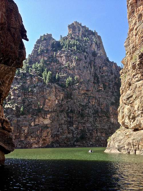
 Evening light on Curecanti Needle as seen from Pioneer Point Overlook
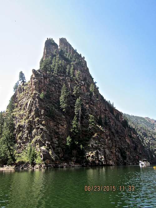 Curecanti Needle as seen from our kayak
Curecanti Needle is a 700 foot granite spire located deep within Curecanti National Recreation Area in western Colorado. The spire was a notable landmark to generations of natives and pioneers.
It is not easily accessible since it sits deep within the gorge of Morrow Point Reservoir. You can view Curecanti Needle from the Pioneer Point Overlook - see photo on the left. One of the best ways to hike from the rim to the river is the Curecanti Creek Trail starting Pioneer Point Overlook. This trail brings you just across from the Needle.
The Needle was used for many years as a advertising symbol for the Denver and Rio Grande Western Railroad. The railway ran along the northern bank of the Gunnison River and passed near the Needle.
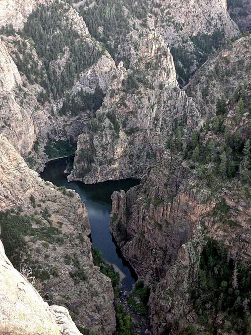
The canyon over Morrow Point Reservoir eventually leads into Black Canyon of the Gunnison River National Park. The Black Canyon stretches 48 miles between Gunnison and Montrose. Part of the canyon is protected as a National Park (Black canyon proper), part of it as a National Recreation Area (Curecanti).
Curecanti Needle rises straight out of the water from Morrow Point reservoir over Gunnison River. At one time there was a flag raised atop the needle to commemorate a brave surveyor who lost his life on the steep sides of the canyon as he was sighting the route fro the railroad. The flag is gone, but we found metal pins from the railroad atop the needle.
Denver and Rio Grande Railroad picked this spire as its logo back in 1884. Today the original Denver&Rio Grande tracks are under the Morrow Point impound water, but in their day, passengers would get out and stare straight up at the needle. General William Jackson Palmer, owner of the Denver&Rio Grande railroad saw the needle as a promotional tool. He was quick to call it "The scenic line of America." And his marketing manager went even further and started marketing with "The scenic line of the world."
Who was Curecanti? Curecanti was a Ute Indian sub-chief who roamed through eastern and southern Colorado from the 1860s and 1870s. Some resources call him Curicata, a Tabeguache Ute Indian Chief.![Chief Curecanti and 2 women]()

Getting There
 Approach to Curecanti Needle - swimming from Curecanti Creek
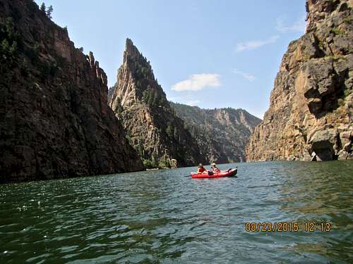 Morrow Point reservoir with Curecanti Needle in the background
Map of Curecanti NRP from national park service - click here
U.S. Highway 50 runs the length of Curecanti between Montrose and Gunnison, Colorado. The recreation area is also accessed from CO Hwy 149 and CO Hwy 92.
Public Transportation: complicated, by bus or trail to Grand Junction, and then hitchhike
Plane: Commercial airline service available to Gunnison, Montrose, and Grand Junction. You can rent a car at the airport.
The U.S. 50 runs close by the Needle but there is no direct access. There is also no trail. The closest developed trail is the Curecanti Creek Trail, which follows the moderately steep descent of Curecanti Creek south to its entry into Morrow Point Reservoir. This trail brings you directly across the river from the Needle (see photo on the left).
Another option is to paddle to the Curecanti Needle from Pine Creek Trailhead. It is about 5 miles down the reservoir. Paddling down is easy since there is a good flow, but closer to the Needle the current slows down. Paddling back is a work out especially towards the end and your kayak is loaded with camping and climbing gear. Luckily, there is a trail along Gunnison river for the last mile and when you get tired, you can carry your boat and gear up the trail.
Another option is to hike down the Curecanti Creek Trail from Pioneer Point Overlook. It is accessible from CO-92, 5.7 miles west of its junction with US-50. The trails descends 900 feet (270 meters) in 2 miles to the small bay where Curecanti Creek drains into the Morrow Point Reservoir (= Gunnison River). You can either carry a small boat, or some other floatable device. Swimming across the reservoir is an option as well, but remember the water is very cold, released from the bottom of the dam. Wet suit is recommended for swimming.
Route
Elevation: 7,739 feet = 2,359 mProminence: 700 feet = 210 m
Colorado Rank: 3057
Saddle elevation: 7,460
Parent Lineage: Fitzpatrick Mesa
There are several routes leading the the summit. We chose the most popular and best rated Northwest Rib 5.9-.
Northwest Rib 5.9-
Take a boat, floatables or swim (wet suit recommended) to the down river end of Curecanti Needle. Secure your boat. Scramble up the loose scree gully to the saddle. There is some brush at trees and higher sections. From the saddle go left along the ledge until you see a large grassy ledge with great views of the Gunnison River below.
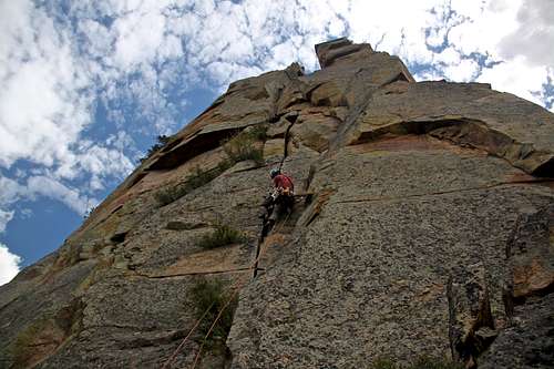
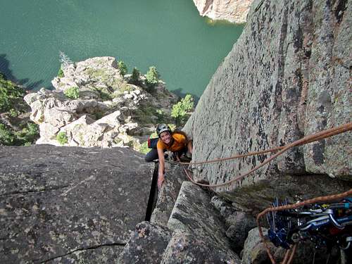
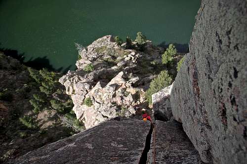
Pitch 1: starts at the beginning of the large ledge. We spent a little time here to try to figure it out. The large wall with multiple opening cracks did not appear easy, aerated loose rock was hard to protect. We chose a pillar (see photo below) with many features and eventually crossed into a chimney with a tree. The tree had a sling around it - what an reassuring sign. The pillar was facing north, directly to the water. The route eventually lead to a another ledge with tree with slings. I would rate it 5.6, could be climbed more difficult as 5.7 - several variations right next to each other.
Pitch 2: Walk left around the ledge and pass the corner until you face directly the reservoir and find yourself across from Curecanti Creek Trail. Look up - there is a beautiful crack and "money pitch" of the climb. The hand crack is great with a clean rock, and there are also many features on the rock, so you have choices either climb a crack or use the face. There are several pitons in this section. At some point the hand crack becomes pretty wide, but if you reach deep inside there are holds there. There is a ledge with slings around a large boulder for an anchor. 5.9-
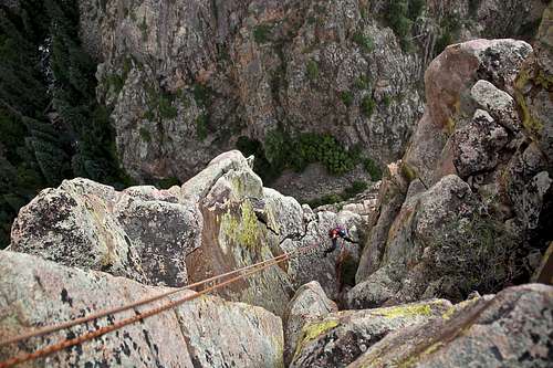
Pitch 3: Climb more cracks and traverse slightly left (very obvious). This pitch is short and is protected with pitons. There is another anchor with slings around it.
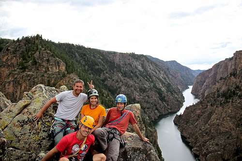
Final Scramble: it is still cca 40 m of scrambling to reach the actual summit, mostly 4th class with a few low 5th class moves. The exposure is immense and a mistake would most likely end up in a fatality. Consider staying roped up on this section. There was a large plastic summit register up there - we found it filled with water and no sign in register in it. The views from the summit are spectacular. I was posing for a photo and nearly got snapped by an eagle flying right above - my partners ran to me to scare the eagle away.
Remember you will be a tourist attraction on this route. People taking the boat tour will be stopping by and taking photos of you.
Descent: There are bolted rappel stations on the south side of the tower. Two double rope rappels and one single rappel will bring you down. Walk/scramble down between 2nd and 3rd rap for about 10-15 meters.
Gear: Two 60 meter ropes. Personal climbing gear. Camalots up to size 4 (one #4 is plenty), consider doubles for 1 and 2 (we did not require those, but our leader was very competent), nuts, slings.
Variation: Start climbing right from the river. Traverse above the water to start in a wide, left facing corner with a piton. Stay on the ridge all the way. There are some pins marking the way.
 The Money Pitch
 | 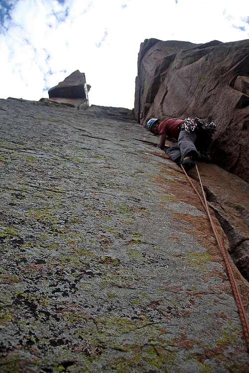 Pitch 3 - Curecanti Needle
 |
 2nd pitch Curecanti Needle
 | 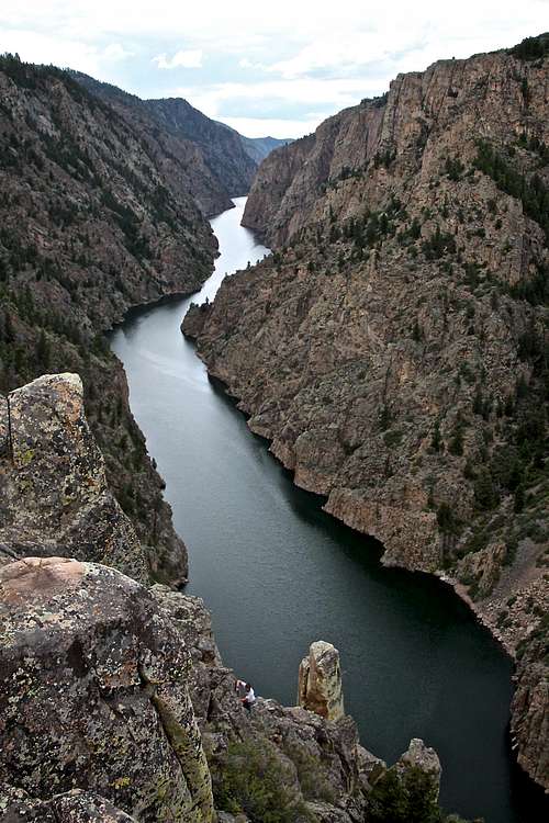 4th classing to the summit
 |
 Curecanti Needle summit
 | 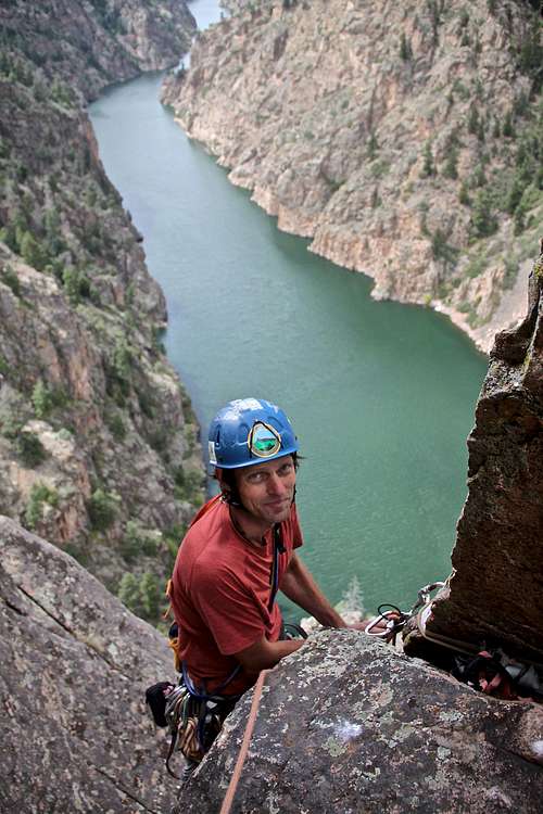 What a view!
 |
 Excellent rock
 | 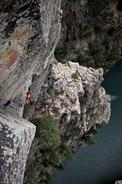 Curecanti Needle
 |
 First rappel
 | 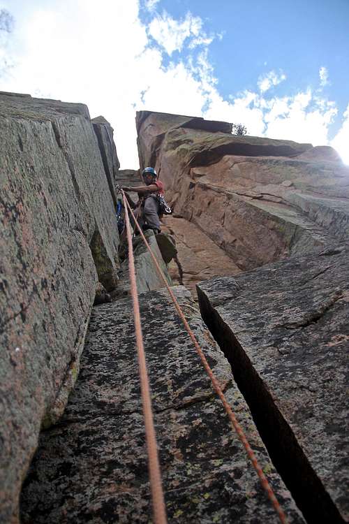 Anchors at the top of 2nd pitch
 |
Red Tape
There is no red tape. Climbing, hiking, boating, swimming in Curecanti National Recreation Area is free. Remember the water is released from the bottom of the dam - it is very cold. If you decide to swim consider a wet suit and some floatable devices.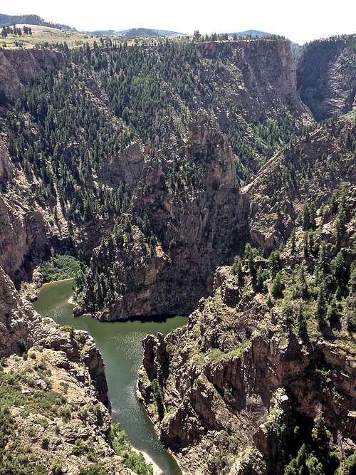 Curecanti Needle with a ay where Curecanti Creek drains into Morrow Point
 | 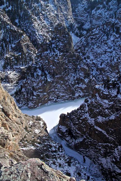 Curecanti Needle with frozen Morrow Point Reservoir
 |
When to Climb
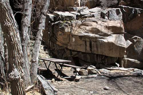
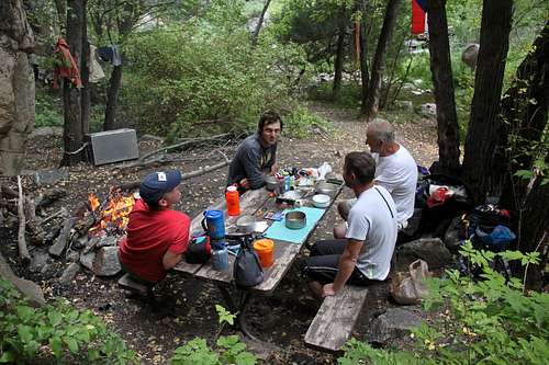
Summer is the easiest - boating more pleasant. I have seen people descending the Curecanti Creek Trail in the winter and crossing over a frozen reservoir, but this poses a risk of falling through and drowning + climbing 5.9 route in winter conditions.Camping
There is excellent camping at the end of Curecanti Creek trail with a camping table, and even a fire pit. Bear food container is there as well, but has been very dirty over the past 2 years. There is a dry vault toilet.Another great camping spot is on the southeast side of the Curecanti Needle, you need a boat to get there. There is a small beach with a patch of grass. This is a primitive area. You cannot hike from here. There are no toilet facilities.