
|
|
Canyon |
|---|---|
|
|
38.56400°N / 105.239°W |
|
|
Hiking, Trad Climbing, Sport Climbing, Toprope, Bouldering |
|
|
Summer, Fall |
|
|
Overview
Elevenmile Canyon is a relatively unknown gem of the Pikes Peak region. Located south of the small town of Lake George, this wide canyon was cut by the South Platte River, leaving clean gray granite cliffs suitable for rock climbing. Unlike the unstable rock climbing elsewhere in the Pikes Peak region, such as Garden of the Gods, Elevenmile Canyon is comprised of solid, polished granite. Rock climbing routes here run the gamut - major crack systems, delicate face climbs, trad, sport, single pitch, multi-pitch, and bouldering. The best feature of the canyon is that you won't find the crowds normally present at crags nearer to Denver, Boulder, and Colorado Springs. Indeed, there are typically far more fly fishermen in Elevenmile than rock climbers.
I won't include any information about fishing or water sports on this page, but fishermen should note that this canyon is supposed to be one of the best fly fishing locations in Colorado. Elevenmile Reservoir has a lot of boating and fishing as well. I've seen kayakers in the canyon, but I have no idea where they actually kayak. Hunters can also be seen in this area, especially during duck season.
I intend this page to be an overview of the canyon, and I'll add a few rock climbing routes as time allows. If you wish to add a route to Elevenmile Canyon, please use "add a route" function, and simply use the route's name to name the page. I'll link it into the separate crag sections that I'll add below. Please send me an email or a private message if you add a route.
Getting There
From the east or west, drive US Highway 24 to the small town of Lake George. In the center of Lake George, near a fishing shop, turn south onto Park County 96. Follow PC 96 for one mile until you reach the canyon entrance and a small kiosk. There is a $5 fee per day in Elevenmile Canyon, and you pay at the kiosk. Enter the canyon.The main canyon road is improved dirt. Passenger cars should be fine driving here, but the road often has a bad washboard when it hasn't been grated in a while. The dirt road isn't very wide, and it can be tough to pass vehicles in the other direction at times. Drive slowly.
NOTE: If coming from the west, do not follow signs for Elevenmile Reservoir. This will not take you to the canyon.
Geology, History, and Ethics
 TOPO! Map of Area
Geology
The South Platte River begins on the northern flanks of Mount Lincoln and flows across South Park, eventually pooling in the southwestern portion of the park in Elevenmile Reservoir, near Lake George. The water from Elevenmile Reservoir flows northeast and cuts into the Pikes Peak batholith, creating Elevenmile Canyon with millions of years of snowmelt. The soaring walls of the canyon are comprised of Pikes Peak pinkish granite, polished grey from years of erosion. The focal point of the canyon is the South Platte River, and its cold and rushing waters. A dense Ponderosa Pine forest lines the gentler canyon walls, interspersed with imposing granite cliffs.
The mouth of Elevenmile Canyon is approximately 8000' above sea level, and the base of the canyon rises to 8500' at the reservoir. The canyon walls rise dramatically from the river, sometimes sweeping up 400-500' above the water. The high altitude of this area precludes most types of climbing in late fall through mid spring due to snowpack and closure.
History
From what is known, climbing began in Elevenmile Canyon in the 1960s, and the Colorado Mountain Club probably climbed the first routes in the canyon. Early interest in the canyon was stymied by other popular front range climbing locations like Garden of the Gods and Eldorado Canyon. Many unclimbed lines remained dormant for a decade.
The late 1970s brought some renewed interest, and difficult climbs in the 5.11 range began to go up throughout the canyon. The 1980s brought full-on interest in Elevenmile. Climbers such as Ricard Aschert, Dale Goddard, Mark Milligan, Mark Rolofson, Neil Cannon, and Bob D'Antonio began to send classic routes up to 5.13. The discovery of Shelf Road near Canyon City again drew climbers from Elevenmile, and activity in the canyon lay dormant until the mid 1990s.
Since the 1990s, Elevenmile Canyon has had a period of renewed interest, but the number of climbers that frequent this high canyon are dwarfed by the hordes that descend upon Garden of the Gods, Shelf Road, and the crags near Boulder and Denver. Indeed, there are countless routes in Elevenmile waiting for development, scores more if one explores some of the side canyons.
Ethics
Because Elevenmile Canyon gets less traffic than other crags, the potential for ethics violations here is great, simply because there might be nobody around who will notice what you are doing. Unfortunately, the 1980s brought a rush of indiscriminate bolting, chipping, and gluing, like many other crags around the country. Since then, climbers have become a more ethical group, but problems still occur at Elevenmile. Today, phantom bolters are the big issue, but their handiwork is usually quickly removed.
The consensus among climbers here is that Elevenmile should remain mostly traditional, and bolting should only occur on face climbs where no natural protection is possible. Chipping and gluing, like everywhere else in the world, is completely unacceptable.
The Rocks
 TOPO! Map of Elevenmile
Guardian Wall
(0.4 mile)Guardian Wall is a short, slabby wall with just a few routes in the 5.9-5.11 range.
Routes:
None on summitpost.
The Spray Wall
(2.4 miles)Spray Wall, named for its proximity to the river, contains several very difficult routes in the 5.11-5.13 range. Because this rock is slabby, most routes are sport-bolted. Park along the road in one of the small pull-offs.
Routes:
None on summitpost.
Bigot Rocks
(2.6 miles)No clue why this crag is named "Bigot Rocks." This rock has a handful of routes, mixed between sport and trad.Park along the road in one of the small pull-offs.
Routes:
None on summitpost.
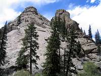
 The Tooth
The Tooth
(2.7 miles)This well-named crag is a giant rock protruding from the ground across from Elevenmile Dome. It has about 3 routes, one sport, two trad.Park along the road in one of the small pull-offs.
Routes:
None on summitpost.
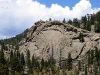
 Elevenmile Dome
Elevenmile Dome
(2.8 miles)Elevenmile Dome is one of the three major rocks in Elevenmile Canyon. This south-facing rock has quite a few great moderate routes. Routes can be rappelled or you can scramble to the top of the Dome and walk off either side. There are a few two pitch climbs on the Dome. There are several parking areas along the base of the Dome, but they fill up quickly.
Routes:
None on summitpost.
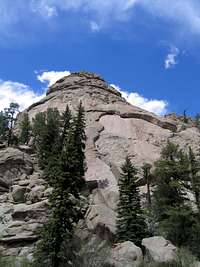
 Arch Rock
Arch Rock
(4.0 miles)Arch Rock is another of the three major crags in the canyon. Rising some 500 feet from the South Platte River, Arch Rock contains several fantastic moderate routes on even better rock. Arch has a few fun sport routes, but the majority of climbs here are traditional. All routes that go to the top are typically walked-off - there are no rap anchors on most of the lines. Parking can be a pain here. There are few areas to park off the road, so most climbers will want to park in a large, designated area about 1/3 mile down the canyon. To approach Arch Rock, scramble and hike on use trails straight up from the road until you hit the base of the routes.
Routes:
- The Staircase (5.5)
- Hollow Flake(5.6)
- Sprout Route (5.11)
- Captain Fist (5.8)
Eagle Ridge
(4.2 miles)This crag sees little traffic, and has a few difficult routes. From Turret Dome, go uphill and east to reach the crag. This one has potential for new routes.
Routes:
None on summitpost.
 Turret Dome
Turret Dome
(4.3 miles)Along with Elevenmile Dome and Arch Rock, Turret Dome makes up the third major crag in this canyon. This crag has several great routes from 5.0 to 5.11, several are multi-pitch, and nearly all are trad. Park in a large area about 1/4 mile upriver from the Dome.
Routes:
UN 8620 "Turret Dome": Guides Route to Summit.
Hard Rock
(4.7 miles)Tucked away from the road, this rock has three "hard" routes from 5.11c to 5.12. Park near Springer Gulch Campground and walk northerly past Teale Tower, past Sports Crag, and then north to Hard Rock.
Routes:
None on summitpost.
Sports Crag
(5.1 miles)This short crag has a bunch of routes in the 5.8 to 5.12 range.
Routes:
None on summitpost.
Teale Tower
(5.2 miles)This tower has a few routes, all above 5.10+. The "Teale Tower Route (5.11-) is supposedly a three star line, going for two pitches to the top. Park along the road.
Routes:
None on summitpost.
Springer Gulch
(5.4 miles)Located near the Springer Gulch campsite, this crag has a dozen routes in the 5.10 - 5.12 range. Park in the campground parking area.
Routes:
None on summitpost.
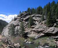
 River Wall
River Wall
(6.3 miles)Another short crag with a dozen fun routes. Park on the other side of the river in a three-car pullout (directly across from a large roof). Walk downriver along the road, cross the river past a bridge, and hike uphill, angle back toward the river, and descend to the base of the rock wall. To reach all the routes, simply walk along a footpath along the river's edge. To reach topropes, walk all the way upriver until the crag ends, then scramble uphill, using the path of least resistance to the top of the crags. This walk-around is Class 3. The top of the crags is generally safe and flat, and allows you access to several anchors and trees.
Routes:
- Loaf and Jug (5.7)
Short Wall
(6.7 miles)A short crag with about 3 routes. The boulders below short wall have some of the best bouldering in the canyon.
Routes:
None on summitpost.
Spy Rock
(6.9 miles)Another short crag. There is excellent bouldering up the hill and west of Spy Wall.
Routes:
None on summitpost.
Indulgence Crag
(7.0 miles)Indulge yourself here if you are an expert trad leader. Lots of tough trad routes from 5.9 to 5.12. Bob D'Antonio's guidebook says, "be prepared to place all the latest technology you have."
Routes:
None on summitpost.
Cove Rock
(8.1 miles)Cove Rock has a handful of shorter routes, split between sport and trad.
Routes:
None on summitpost.
Pine Cone Dome
(8.2 miles)Pine Cone has a mix of easier trad routes and a few tougher ones. This is a good spot for a new trad leader with routes in the 5.5 -5.6 range. Park along the road in pull-outs.
Routes:
None on summitpost.
Idlewild
(8.4 miles)The Idlewild Picnic Area has a bunch of small rocks suitable for climbing. Most are in the 5.9-5.12 range. Park at the picnic area.
Routes:
None on summitpost.
Baboon Rock Area
(8.5 miles)Baboon Rock has a handful of 5.10 and .11 routes on excellent granite. To the east is Corridor Crag, which also has a few routes. Icicle Slab is the obvious crag to the west with a big roof. Camp Rock is at the entrance to the spillway, and is a great spot for toproping, and has a few easy routes.
Routes:
None on summitpost.
The Fortress
(8.9 miles)Near the end of the dirt road lies The Fortress. Boasting 10 routes on 5.9 and higher rock, this excellent crag is worth a visit.
Routes:
None on summitpost.
Red Tape
There is a $5.00 fee per vehicle to enter Elevenmile Canyon, paid at a kiosk at the canyon's entrance. If there is no park ranger at the entrance, leave your payment in some small envelopes that are provided.There is a Boy Scouts of America camp (Camp Alexander) about 2 miles into the canyon. The camp is private, well-marked, and affects about 1/2 mile of the south side. Do not park, hike, or camp near the Boy Scout's land.
Camping
Camping is available throughout the canyon. Elevenmile Canyon is contained within the Pike National Forest, so the several named campsites are regulated by the PNF. The first come, first served campsites are generally car-camping, and fill up quickly in late spring and summer.The main campsites, in order from the entrance:
Riverside Campsite
O'Brian Gulch Campsite
Springer Gulch Campsite
Wagon Tongue Campsite
Cove Campsite
Spillway Campsite
There are also several designated picnic sites:
Elevenmile Picnic Site
Messenger Gulch Picnic Site
Idlewild Picnic Site
*The above campsites and picnic areas are all marked on this TOPO! map.
External Links and Guidebooks
Links
The Mountain Project - Elevenmile Canyon. This rock climbing website, formerly known as "climbingboulder.com" has excellent information on many of the climbs in Elevenmile.
Guidebooks
(Links go to www.amazon.com)Classic Rock Climbs No. 3: Mueller State Park and Elevenmile Canyon - Bob D'Antonio. This is the guidebook to buy for Elevenmile Canyon. Great info by one of the canyon's pioneers.
Front Range Topropes - Fred Knapp. This book has toprope options for several places in the front range. The River Wall is featured from Elevenmile Canyon.