Introduction
Upper Kern River Basin
Sequoia & Kings Canyon National Park (SEKI)
Sierra Nevada, California, USA
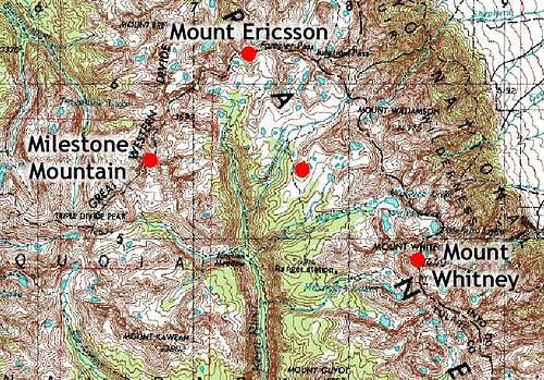
The upper Kern River basin is a rugged and remote region of the High Sierra. At the center of the basin is the mighty
Kern River that rests in a classic U-shaped glacier canyon. The upper Kern River basin is bounded on three sides:
-western boundary: the
Great Western Divide
-northern boundary: the
Kings-Kern Divide
-eastern boundary:
Mount Whitney and the Sierra Crest
Our two-week trek through the upper Kern River basin took us over Shepherd’s Pass, to Mount Ericsson on the Kings-Kern Divide, down to the Great Western Divide to Milestone Mountain, over to Lake Tulainyo near Mount Whitney, over to the Bighorn Plateau and back over Shepherd’s Pass.
Over Shepherd’s Pass
The name “
Shepherd’s Pass” is a poor name for this pass. A better name would be something like “
I Wish I Had a Lighter Backpack Pass,” or better yet “
Poke Me in the Eye with A Sharp Stick Pass.” The trail is 12 miles long and climbs over a vertical mile to an elevation of 12,000 feet on the Sierra Crest. And if the climb wasn’t bad enough, there is a 500-foot descent midway up the trail. Throw in some 90-pound backpacks with climbing gear and two weeks of provisions, and you’ve got yourself something that could make a grown man cry.
Kings-Kern Divide
Kings-Kern Divide
Once we made it over Shepherd’s Pass, we set out cross-country over to the Kings-Kern Divide. We made a brief detour up onto Diamond Mesa to get a better view of the Kern River Basin. What a spectacular sight!
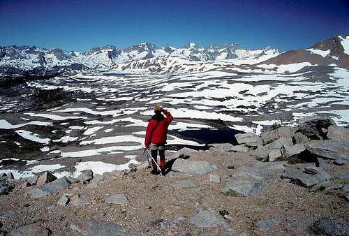
We camped in the area below the Kings-Kern Divide for three days, climbing Mount Ericsson (13,608 feet) and swimming in the alpine lakes.
Great Western Divide
The Great Western Divide
The next destination on our itinerary was Milestone Basin on the Great Western Divide. We headed south down the Kern River (that was more like a creek up there) and ascended up into Milestone Basin.
Milestone Basin proved to be a big disappointment to us. Horse packers had really ruined the area. Someone had built a giant fire ring in an open lake-side meadow that was clearly above the “No Fire” altitude limit. The meadow was strewn with garbage include a smashed fishing tackle box, a broken folding table, torn tarps, and a variety of other trash. The meadow had been trampled by horses. Further up, past a sign that stated, “No horses beyond this point,” we followed a well-worn trail of horse manure to another trampled and muddy meadow where we found more garbage. I did contact the National Park Service after the trip to discuss the problem. Their response to me was, “So what?”
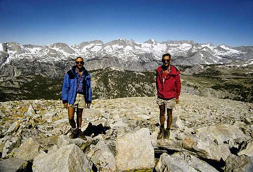
One the sixth day of our tour we climbed the West Ridge of Milestone Mountain (13,641 feet). The view from this lofty and isolated summit is spectacular. The day after our climb we headed for the Kern River.
Kern River
Okay for those of you thinking of hiking up or down the western side of the Kern River between Milestone Basin and the Kaweah River:
Don’t. Perhaps I should qualify that:
Don’t until you like bushwacking through Manzanita and
blowdown. Those 100-foot redwoods that grow along the Kern River get blown down by winter avalanches and they make for some gnarly obstacles when they’re lying on the ground.
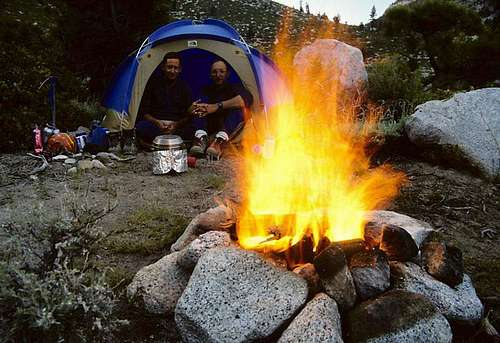
It was nice to get down out of the snow and ice and have a warm campfire and steam sauna in Junction Meadow. The next day we had one heck of a time crossing the Kern River. Everything got completely soaked, so we spent another day by the river drying our gear and resting. Of course we had another steam sauna.
Tulainyo Lake
We always wanted to see Tulainyo Lake (12,820 feet), reported to be the highest lake in North America. So we made the long hike up Wallace Creek, which is legendary for its mosquitos. We ran out of mosquito repellent during the hike up the creek. We crashed at Wallace Lake and finished the trip the next day. It was worth the effort.
Bighorn Plateau
Bighorn Plateau has the reputation for having the best panoramic view of the High Sierra than another peak in the range. Golly, can’t miss that! So our next stop was the Bighorn Plateau on the Pacific Crest National Scenic Trail.


Comments
Post a Comment