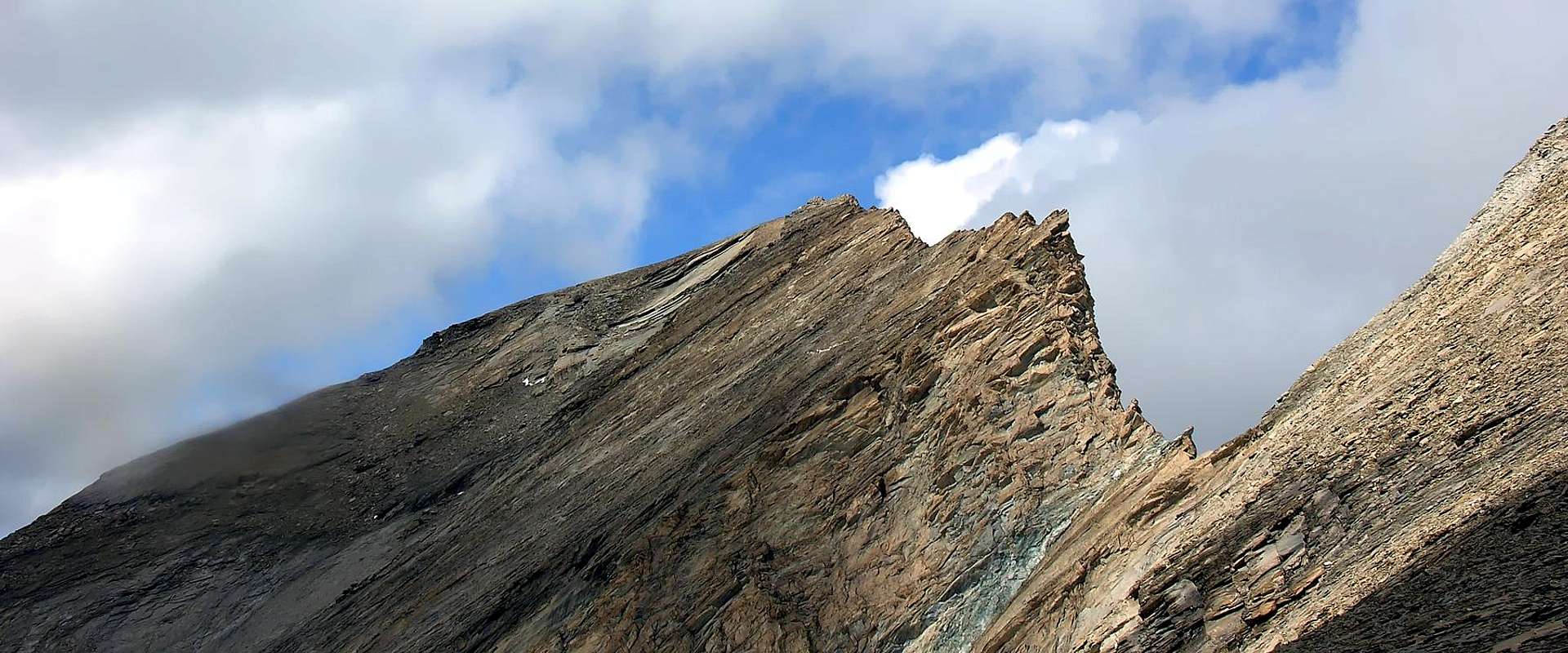
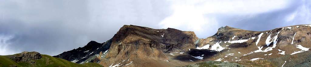
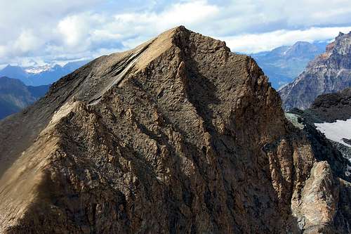
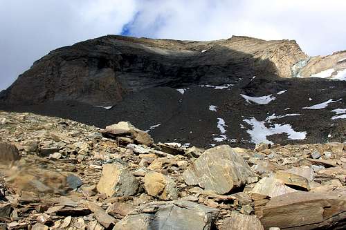
More elevated peak and centrally prepared in the triptych also called "trittico" of Points Taou Blanc/The Aouillè/Cima of Entrelor that rises on the dividing crest among the Val of Rhêmes (to West) and the Valsavarenche (to East). Surely the most important as topographical knot and for height, but also the less frequented, causes his impervious Western and Oriental precipices, as well as the game Crest South (to see under the photograph) toward the Taou Blanc (3.438m). The same however, attractive to the appearance, it is formed not from good rock to crumble easily herself for this reason it doesn't adapt to a sure climb; it results crossed an only time and in descent. Beyond, and to the left of the same, the particular West Wall unfolds, with the shape of a great concave shell as well as banded at the base by a steep rocky base that vertically almost prevents access, which can take place on its more broken Southern edge through a band of broken and inclined rocks (very delicate climb), followed however by an easy slope formed by broken and crumbled rocks, alternating, however, with smooth and polished slabs that are not always easy to climb . On the opposite or Northern side, on the other hand, always from the Vaudaletta or Vaudalettaz Valley, the West-Northwest Crest rises, of ocher-yellow rock which, like the previous wall, is more complicated than not difficult to climb. The Northern side of the same rises towards the Summit forming a Northwestern Face, small and compressed by the same crest and from the Northeast Ridge that descends towards the Cima di Entrelor (3.426/30m); the same is divided into two sectors: the first or NW (uphill route in July 2007) and a second or W-NW. The latter improperly considered as Western Slope (in "Gran Paradiso Parco Nazionale", 1934, 1963, 1980 on page 648 for the descent of July 1888). At the base of which, after a glacial-snowfield (remnant of an extinct glacier) followed by three lakes (2.983, 2.968 meters) , that originates the Torrent de Vaudalettaz. On the Eastern side, on the other hand, the small (approximately 120 meters), but very large and very steep East Face, is highlighted, which falls vertically on the Glacier de l'Aouiller or Aouillé with various veins of yellowish rock, alternating with narrow and very steep gullies, clearly shattered. The ascent of which by the Engineer Pio Paganini perhaps in the summer of 1880 was questioned both by the surveys of the Reverend W.B.A. Coolidge (climber with Christian Almer junior of Cresta NE in August 1885) in the "Alpine Journal", 1885. Who from the description of G. Bobba and L. Vaccarone in "Guide to the Western Alps", 1896, p. 142 as even evidenced by E. Andreiis, Chabod and M.C. Santi in "Gran Paradiso National Park", 1934, 1963, 1980 on page 650; probably it refers to the E-NE Wall, which is the continuation, beyond a small E-NE Spur, of this one. This also applies to the Variant by R.Godefroy, V. and R. Puiseux of 28 July 1911, also because the research for the technical difficulties, in addition to the extreme danger, certainly do not marry with the time; surely more dedicated to the search for an alternative route on a slope with respect to the starting point (see third photo below). More within reach (and logical but no less dangerous, because it allows the ascent from the Aouillé Glacier) the "Diagonal Variant" of June 1979 because it reaches the South Crest just North of the vertical jump and, through the latter, leads to the Summit. In its right (North) margin it sends East-northeast a small spur that heads towards the collar / saddle (3.117m), towards Crête dell'Aouillé (better known as Punta delle Meyes or Pointe des Meyes; 3.360, 3.271, 3.189, 3.160, 3.101 meters), designed to separate the Plan Borgno Vallon (Southwest) from that of the Meyes (East-northeast) as well as the Aouiller Glacier from that by Pertcha or Percià. Further North, instead the Standard Route is rather simple and consists in a brief crossing for crest from the Summit of Entrelor (3.397m), with which shares to a large extent the usual itinerary of ascent of it, even if this last is more rather frequented so much that develops us to you an annual competition of ski-mountaineering (Trophy Robert Rollandoz, founded in 1974 and joint in 2010 to her XXXVI° Sporting Event). It shears therefore a little frequented as final destination by itself, on the contrary and rather of complement to the Top of Entrelor and man to be allowed to enrich the proper personal carnet of slopes through a brief extension of the itinerary. It deserves, in every case, a visit thanks to the wild environment, more isolated and surely uncontaminated. Seen on the great Tableland of the Nivolé (Valsavarenche) to if and on the tall heading of the Valley of Rhêmes to SW; beautiful glimpses on the Grande Rousse (3.607m), great East Face, to NW and on the Grande Traversière (3.496m) to or, while on the slope Western North polls the Gran Paradiso Chain (4.061m), what it frontally hacks here him in longitudinal sense South/North in all of her ampleness and majesty.
Vetta più elevata e disposta centralmente nel trittico di punte Taou Blanc/l'Aouillè/Cima di Entrelor che sorgono sulla cresta divisoria fra la Val di Rhêmes (ad Ovest) e la Valsavarenche (ad Est). Sicuramente la più importante in qualità di nodo topografico e per altezza, ma altresì la meno frequentata, causa i suoi impervi dirupi Occidentali ed Orientali, nonché l'ardita Cresta Sud (vedi fotografia soprastante) verso il Taou Blanc (3.438 m). La stessa però, per quanto attraente all'apparenza, é formata da roccia non buona e facile a sgretolarsi per la qual cosa non adatta ad un'arrampicata sicura; risulta percorsa una sola volta ed in discesa nell'agosto del 1928. Oltre, ed a sinistra della medesima, si dispiega la particolare Parete Ovest, dalla forma di enormemente largo conchiglione concavo nonché fasciata alla base da un'erto zoccolo roccioso che verticalmente quasi ne impedisce l'accesso; lo stesso può avvenire sul suo più rotto lembo Meridionale tramite una fascia di rocce rotte ed inclinate (percorso molto delicato), seguite però da un facile pendio formato da rocce spezzate e sgretolate, alternate, però, a placche lisce e levigate non sempre di facile arrampicata. Sul lato opposto o Settentrionale sale invece, sempre dal Vallone della Vaudaletta od anche Vaudalettaz, la Cresta Ovest-nordovest, di roccia color giallo ocra che, come la parete precedente risulta più complicata che non difficile da salire. Il lato Settentrionale della stessa sale in direzione della Vetta formando una Parete Nordovest, piccola e compressa dalla medesima cresta e da quella Nordest che scende verso la Cima di Entrelor (3.426/30 m); la medesima si sdoppia in due settori: il primo o NO (percorso in salita nel luglio 2007) nonché l'O-NO. Con quest'ultimo impropriamente considerato come Versante Ovest (in "Gran Paradiso Parco Nazionale", alla pagina 648 per la discesa del luglio 1888). Alla base della quale, dopo un glacio-nevato (resto di un antichissimo ghiacciaio ormai estinto) seguito da tre laghetti (2.983, 2968 metri), si origina il Torrent de Vaudalettaz. Invece sul lato Orientale si mette in mostra la piccola (all'incirca 120 metri), ma molto larga e ripidissima Parete Est, che precipita verticalmente sul Glacier de l'Aouiller oppure Aouillé con diverse nervature di roccia giallastra, alternate a stretti e ripidissimi canaloni in genere rocciosi, con entrambi in netta frantumazione. La salita della quale da parte dell'Ingegnere Pio Paganini forse nell'estate del 1880 é stata messa in discussione sia dai rilievi del Reverendo W.B.A. Coolidge (salitore con Christian Almer junior della Cresta N.E nell'agosto del 1885) nell' "Alpine Journal", 1885, che dalla descrizione di G. Bobba e L. Vaccarone in "Guida delle Alpi Occidentali", 1896, pag. 142. Come evidenziano E. Andreis, Chabod ed M.C. Santi in "Gran Paradiso Parco Nazionale", 1934, 1963, 1980 alla pagina 650; probabilmente ci si riferisce alla Parete E-NE, che é la continuazione, oltre un piccolo sperone E-NE, di questa. Ciò vale anche per la Variante di R.Godefroy, V e R. Puiseux del 28 luglio 1911, anche perché la ricerca delle difficoltà tecniche, oltre all'estrema pericolosità, certamente non si sposano con l'epoca; sicuramente più dedita alla ricerca di un percorso alternativo su di un versante (vedi terza foto al di sotto). Più alla portata (nonché logica ma non meno pericolosa, perché permette la salita dal Ghiacciaio dello Aouillé) la "Variante Diagonale" del giugno 1979 perché raggiunge la Cresta Sud appena a Nord del salto verticale e, tramite quest'ultima, conduce alla Vetta. Nel suo margine destro (Nord) invia verso Est-nordest uno speroncino che si indirizza verso il colletto / sella (3.117 m), in direzione Crête dell'Aouillé (più conosciuta come Punta delle Meyes o Pointe des Meyes; 3.360, 3271, 3189, 3160, 3101 metri), atta a separare il Vallone di Plan Borgno (Sudovest) da quello delle Meyes (Est-nordest) nonché il Ghiacciaio dell'Aouiller da quello di Pertcha. Più a Nord, la Via Normale invece è piuttosto semplice e consiste in una breve traversata per cresta dalla Cima di Entrelor (3.428/30 m), con la quale ne condivide in gran parte l'usuale itinerario di ascesa, anche se quest'ultima è alquanto più frequentata tanto che vi ci svolge una gara annuale di sci-alpinismo (Trofeo Robert Rollandoz, istituito nel 1974 e giunto nel 2010 alla sua XXXVI° Edizione). Cima quindi poco frequentata come meta finale di per sé, bensì e piuttosto di complemento alla Cima di Entrelor e tale da permettere di arricchire il proprio carnet personale di salite tramite un breve allungamento dell'itinerario. Merita, in ogni caso, una visita grazie all'ambiente selvaggio, più isolato e sicuramente incontaminato. Viste sul Pian del Nivolé (Valsavarenche) a SE e sull'alta testata della Valle di Rhêmes a SW; bei colpi d'occhio sulla grande Parete E della Grande Rousse (3.607 m), a NW e sulla Grande Traversière (3.496 m) ad O, mentre sul versante Nord Occidentale svetta la Catena del Gran Paradiso (4.061 m), che qui si staglia frontalmente in senso longitudinale S/N in tutta la sua ampiezza e maestosità.
First Ascents
First on the summit: Engineer Pio Paganini, (Summer, 1880)?.
In winter: Unknown.
NE Ridge (from Entrelor's Summit): W. A. B. Coolidge with Swiss mountain guide Christian Almer Junior, (Aug 23th, 1885), in ascent.
E Wall: ? Engineer Pio Paganini (Summer, 1880)?, in ascent.
E Wall (Right Variant): R. Godefroy, V. Puiseux and R. Puiseux, (Jul 28th, 1911), in ascent.
E Wall (Left Diagonal Variant): Osvaldo Cardellina and Marco Cossard, (Jun 29th, 1979), in ascent from Pont Valsav., Plan Borgno, Aouillé's Glacier.
NE Edge (in left by Est Face): Osvaldo Cardellina and Christian Cardellina (at the age of 10), (Aug 31th, 1983), in ascent by Pont, P. Borgno, Aouillé Glacier.
S Arête: Vittorio Franzinetti and Massimo Mila, (Aug 1928), in descent.
W-NW Slope ((Northern Side of Vaudaletta's Route): Giovanni Bobba and Casimire Thérisod, (Jul 18th, 1888), in descent after the ascent on Cima d'Entrelor and crossing to Cima dell'Aouiller with departure from Thumel Village, Montagna Vaudaletta to Collar about 3.380m.
NW Face (Northern Side of Vaudaletta's Route): Osvaldo Cardellina and Alessandro Cardellina, (Jul 23th, 2007), in ascent from Thumel Hamlet, Vaudaletta Pastures; in descent NE Ridge to Cima d''Entrelor, Col Percià, Percià's Southwestern and Northeastern Summits and Entrelor Col to Péllaud.
W Crest (from Vaudaletta Valley): F. Quaini with Rhêmes mountain guide Casimire Thérisod, (Sep 20th, 1915), in ascent.
W Wall (Southern Side of Vaudaletta's Route): Osvaldo Cardellina and Alessandro Cardellina, (Jul 13th, 2007), in ascent from Thumel Hamlet, Vaudaletta Pastures; in descent NE Ridge to Cima d''Entrelor, round trip towards the Collar about 3.380m, with final descent through Western Slope to Péllaud.
NW Arête: Giovanni Bobba and Casimire Thérisod, (Jul 18th, 1888), in ascent starting from Rhêmes Notre Dame, Thumel Village, Vaudaletta Pastures.
Getting There
BY CAR:
From France: through the Mont Blanc Tunnel or the Col du Petit Saint Bernard: you can drive on SS.26, following directions for Aosta and, before arriving in Villeneuve, turn right toward Introd. Alternatively, you can take motorway A5 (at Courmayeur or Morgex) and exit at Aosta Ovest.
From all the other directions: Get to the Aosta Ovest exit of motorway A5. Then drive on SS.26 Aosta, in the direction of Courmayeur; just after Villeneuve turn left toward Introd. Shortly after Introd, you arrive at a junction: turn left, entering Valsavarenche, and passing through many villages (Degioz, Eaux Rousses, etc.) you can arrive at Pont (1.978m) where the road ends.
BY PLANE:
Aeroporto "Corrado Gex" Saint Christophe (Aosta).
Approach from Pont-Valsavarenche
From Pont di Valsavarenche (1.960m) a comfortable mule track n° 3 starts just behind the Hotel. Toward West into the narrow valley of the Doire Stream of Nivolè and, along a ramp, get the Croce de la Roley (2.313m), (good panoramic point). Follow zigzagging, through a brief stretch, into the big banks of rock, polished by ancient glaciers, into the great Nivolé(t) Tableland utilized for grazing. Leaving in left (Southeast) the path n° 3 towards the entire Nivolé Tableland and to whit same name pass (2.597m; Savoia and Chivasso Town Huts), before the crossing on a little area panoramic and equipping for mini picnic point, after briefly descend at a small bridge 2.322m in wood and through the same wade the Doire (Stream) of the Nivolé. To follow, Northwest direction, by the path 3A/3D as far as the left deviation to Turin or Teureun Alp 2.396m), just immediately in West. Go up, by a semicircular route, on Nivolé dirt road and through the same, leaving left the path n° 3A to Plan Borgnoz, before long to abandon this direction changing in Northeast, by the path n° 3D (E; F; 2h'00/2h'30).
Da Pont di Valsavarenche (1.960 m) prendere la comoda mulattiera n° 3 che parte subito dietro l'Albergo; salire verso W lo stretto valloncello della Doire (torrente) del Nivolè e con una rampa finale raggiungere la Croce de la Roley (2.313 m), ottimo punto panoramico e fotografico. Si continua per breve tratto a serpentina tra grandi banconate di splendida roccia levigata dall'antica erosione glaciale "entrando" nel Pian del Nivolè, grande altipiano di oltre 6 km utile al pascolo. Abbandonando sulla sinistra (SW) il sentiero n° 3 che, attraverso l'intero pianoro, si indirizza verso l'omonimo colle (2.597 m; Rifugi Savoia e Città di Chivasso) dapprima si attraversa un punto panoramico attrezzato a mini area pic nic per poi scendere brevemente verso un piccolo ponte in legno 2.322 m ed attraverso lo stesso si guada la Dora del Nivolé. Seguire, con direzione NW, il sentiero n° 3A/3D sino alla deviazione a sinistra per l'Alpe Turin o Teureun 2.396 m), situata subito a sinistra. Risalire, tramite percorso semicircolare, sulla strada sterrata del Nivolé e con la stessa, abbandonando a sinistra il sentiero n° 3 verso Plan Borgnoz, tosto abbandonare questa direzione cambiandola in NE, tramite il sentiero n°3D (E; F; 2h'00/2h'30).
Approach from Great’s Clapey Bridge
Hardly before the Bridge of the Great Clapier (1.726m) to take the steep enough path/muletrack n° 6/6A that it accompanies from the tall one, on the shore left hydrographical, the run of the Stream Savara; you go beyond two log cabins, the same goes up again with two hairpin bends to the Provet Alp (1.945m) and, changing direction in SW, it is addressed toward the entry of the Meyes's little Valley. Reached the Meyes Desot (Lower) Pasture (2.278m) it passes for the following one Meyes du Meitin (Middle) Alps it crosses a small stream, and it reaches the Meyes Damon (Upper) (2.512m), where it is rejoined with the precedent Approach A (F; 1h'30/2h'00).
Appena prima del Ponte del Grand Clapier (1.726 m) prendere l'abbastanza ripido sentiero/mulattiera n° 6/6A che accompagna dall'alto, sulla riva idrografica sinistra, il percorso del Torrente Savara; oltrepassate due baite, lo stesso risale con due tornanti all'Alpe Provet (1.945 m) e, cambiando direzione in SW, si indirizza verso l'ingresso del Vallone delle Meyes. Raggiunto l'Alpeggio delle Meyes Desot (2.278 m) passa per il successivo delle Meyes du Meitin (di Mezzo), attraversa un piccolo torrente, ed arriva alle Meyes Damon (2.512 m), ove si ricongiunge con il precedente Avvicinamento A (E; F; 1h'30/2h'00).
Approach from Nivolé Pass or Savoia and Chivasso Town Huts
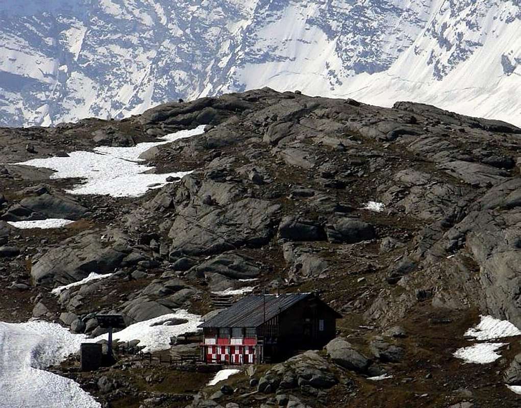
From the Nivolé Pass (2.597m) or from the near Shelters Città di Chivasso (2.600m) and Savoia (2.533m), to follow the whole excavated road superior Nivolé Tableland (ranging rod of prohibition immediately after the two Lakes of the Nivolé and to quota 2.522m, where the path arrives n° 3 coming from Pont Valsavarenche and with direction Of it, passing under the Coast Lombarda, to reach the Shelter P.N.G.P. and immediately after the Plan Borgnoz Pasture (2.672m); to continue, same direction, with the paths n° 6A/9 reaching the approach A to the alternative 2.619m (E; F; 1h'00/1h'30). * * WILD LIFE and WILD NATURE : possibility of sighting of numerous marmots in the underlying tableland and, always among the rodents him squirrel ; besides they race and they jump flocks of chamois and isolated groups of ibex. It also foresees her Red Fox (she could actually follow you to Pont of Valsavarenche!) and not infrequent the flights of couples of eagles or the to circle solitary of the Gypaetus also called Vulture, again recently introduced in the National Park of the Gran Paradiso (the last sample had been just killed in Val of end eight hundred Rhêmes). Present, among the volatile ones, the grouse, the rooster forcello or cock of the wood, the owl and, in abundance, the cuckoo and "squad" of the white partridge. More to earth her salamander, but above all her viper, queen of the sunny stony earths.
Dal Colle del Nivolé (2.597 m) o dai vicini Rifugi Città di Chivasso (2.600 m) e Savoia (2.533 m), seguire tutta la strada sterrata soprastante il Pian del Nivolé (palina di divieto subito dopo i due Laghi del Nivolé ed a quota 2.522 m, ove arriva anche il sentiero n° 3 proveniente da Pont Valsavarenche; continuare con direzione NE, passando sotto la Costa Lombarda, e raggiungere il Casotto P.N.G.P. e subito dopo gli Alpeggi Plan Borgnoz (2.672 m); continuare, stessa direzione, con i sentieri n° 6A/9 raggiungendo l’Avvicinamento A al bivio 2.619 m (E; F; 1h'00/1h'30). ** NATURA SELVAGGIA:: possibilità di avvistamento di numerosissime marmotte nel sottostante pianoro e, sempre tra i roditori lo scoiattolo; inoltre scorazzano branchi di camosci e gruppi isolati di stambecchi. Presente anche la Volpe Rossa (vi potrebbe seguire sino a Pont di Valsavarenche!) e non infrequenti i voli di coppie d'aquila od il volteggiare solitario del Gypaetus, recentemente nuovamente introdotto nel Parco Nazionale del Gran Paradiso (l'ultimo esemplare era stato prorio ucciso in Val di Rhêmes a fine dell'Ottocento). Presenti, tra i volatili, il gallo forcello, il gallo cedrone, il gufo ed, in abbondanza, il cuculo e "squadriglie" di pernice bianca. Più a terra la salamandra, ma soprattutto la vipera, regina delle pietraie assolate.
A) - Route from Meyes Little Valley and Meyes or Pertcha Glacier
After passing some hairpin bends and a tunnel go on along, by a linear diagonal, the road till the confluence of the Valley or, better, Vallon of the Meyes. Now along this steep valley through the path n°6/6A, keeping the right side (ascending) up to the mountain Upper Meyes Alp or Damon (2.512m). Here the slopes become sweeter (by unnumbered trail) and, keeping first the right part along and over the Meyes Torrent up to the quota 2.750 meters around; then the left one, ascend, through the moraines, to the bottleneck bringing to the Glacier of Percià or Pertcha (* in language/patois fit of the Aosta Valley to mean punctured place or perforated by French "perchè" and correspondent to the "fourà" of the dialect of Piedmont) also called, better and better, of the Meyes. On, along the central part of the glacier (warning crevasses) then, turn to the right to gain the main ridge between Val di Rhêmes and Valsavarenche. Cross the Point 3.391m and follow along the slopes bringing to the summit of the Entrelor Point (3.426m); from this to easily go down and quickly through the Crest SW to the underlying collar 3.390m around. To generally go up again along the Crest forms of it from a snowy slant and enough steep from which go out rocks of yellowish schists to manner of flaked leaves employing about twenty minutes for the crossing (EE/A; F; 4h'30/5h'30). * Descent along the same route or, along the ski-mountaineering route, toward the Val di Rhêmes, through the Route B with descent from Pertcha Pass by W Slope.
Dopo aver superato alcuni tornanti e un tunnel continuare lungo la strada sino alla confluenza del Vallone delle Meyes, imboccare il ripido vallone tramite il sentiero n°6/6A tenendosi sulla destra fino a sbucare all'Alpeggio Meyes di Sopra o Damon (2.512 m). Qui il percorso diventa più pianeggiante; continuare con sentiero non numerato tenendosi prima sulla destra seguendo il Torrente delle Meyes dall'alto sino a quota 2.750 m circa e poi sulla sinistra su morene. Si risale una strettoia che porta sul Ghiacciaio di Percià o Pertcha (* in linguaggio/patois valdostano atto a significare luogo bucato o forato dal francese "perché" e corrispondente al fourà del dialetto piemontese) od ancor meglio delle Meyes. Risalirlo al centro facendo attenzione ai crepacci per poi spostarsi sulla destra sino a raggiungere lo spartiacque con la Valle di Rhêmes. Oltrepassare la Quota 3.391 m e risalire il pendio che conduce alla Vetta della Cima di Entrelor (3.426 m); da questa scendere facilmente e velocemente tramite la Cresta S O al sottostante colletto 3.390 m circa. Risalire lungo la Cresta NE formata da un pendio generalmente innevato ed abbastanza ripido dal quale escono fuori rocce di scisti giallastri a guisa di foglie sfaldate, impiegando una ventina di minuti per la traversata (EE/A; F; 4h'30/5h'30). * Discesa lungo la via di salita o altrimenti in Valle di Rhêmes con l'itinerario sci-alpinistico, per mezzo della Via B con discesa dal Colle Pertcha lungo il suo Versante O.
B) - Route from Meyes Little Valley and Pertcha Pass
Through the same one and precedent street actually to quota 2.950m around , where her he abandons; leaving on the left (South) the Glacier of Pertcha or Percià (and perhaps more properly says some Meyes, from the name of the underlying small valley as well as from the homonyms three alps) to decidedly go themselves toward or in direction West to Pertcha Pass (3.148m), sets among the Antesummit NE (3.391m) of the Top of Entrelor to S and the Pointe Fourà or Percià S (3.209m), as well as to horse among the Glaciers of the Meyes (Valsavarenche) and of Entrelor (Valley of Rhêmes). Through a trace on the moraine to progressively go up again with inclination in increase; overcoming the last drawn steep, but brief, to reach the wide depression of the pass (E; 1h'45/2h'15 from the Pasture of the Meyes Damon (of Above; 3h'00/3h'30 from Pont of Valsavarenche).
Variant: in beginning of season, therefore with still a lot of snow, it worthwhile to hold him tall on the right (North) and to proceed through the underlying morainic strata to the Coast Mentò, bringing itself on the street with a brief underlying descent the Point Percià Sud. In this case not to exceed in to rise too much themselves, exposing itself so to the fall of stones from the superior walls. From the pass to turn to S and to actually climb through easily along the Crest N of the first mentioned antesummit deposits, gravels and rubbles to reach to quota 3.272m the conjunction of the two aforesaid glaciers; to continue and, always easily, to reach its Antesummit. From this, changing direction of trail in West-southwest, to overcome first a subsidence bringing then itself to the terminal snowy wall, not too much steep, reaching the final small tower of the Cima of Entrelor; from this to end the slope as in the preceding itinerary (EE/A; F; 5h'00/5h'30, also 6h'00/7h'00 in case of strong snowy or bad conditions of the snow). * Descent along the same route or, through the ski-mountaineering route, toward the Val di Rhêmes by W Slope of the Pertcha Pass.
Con la stessa e precedente via sino a quota 2.950 m circa, dove la si abbandona; lasciando sulla sinistra (SW) il Ghiacciaio di Pertcha o Percià (e forse più propriamente detto delle Meyes, dal nome del sottostante vallone nonché dagli omonimi tre alpeggi) dirigersi decisamente verso O in direzione del Col Pertcha (3.148 m), posto tra l'Antecima N (3.391 m) della Cima di Entrelor a S e la Pointe Fourà o Percià S (3.209 m), nonché a cavallo tra i Ghiacciai delle Meyes (Valsavarenche) e di Entrelor (Valle di Rhêmes. Tramite una traccia sulla morena risalire con pendenza progressivamente in aumento; superando l'ultimo tratto più erto, ma breve, raggiungere la larga depressione del colle (E; 1h'45/2h'15 dall'Alpe delle Meyes Damon (di Sopra; 3h'00/3h'30 da Pont di Valsavarenche).
Variante: in inizio di stagione, quindi con ancora molta neve, conviene tenersi alti sulla destra (N) e procedere tramite le falde moreniche sottostanti alla Costa Mentò, riportandosi sulla via con una breve discesa sottostante la Punta Percià Sud. In questo caso non eccedere nell'elevarsi troppo, esponendosi così alla caduta di pietre dalle soprastanti pareti. Dal colle volgere a S e salire facilmente lungo la Cresta N della prima menzionata antecima per mezzo di detriti, ghiaie e sfasciumi sino a raggiungere a quota 3.272 m la congiunzione dei due predetti ghiacciai; proseguire e, sempre con facilità, raggiungere l'Antecima NE. Da questa, cambiando direzione di marcia in W-SW, superare prima un avvallamento portandosi poi al muro nevoso terminale, non troppo ripido, adducente alla torre finale della Cima di Entrelor; da questa finire la salita come nel precedente itinerario (EE/A; F; 5h'00/5h'30, anche 6h'00/7h'00 in caso di forte innevamento o cattive condizioni della neve). * Discesa lungo la via di salita o altrimenti in Valle di Rhêmes con l'itinerario sci-alpinistico e relativa discesa dal Colle Pertcha lungo il suo Versante O.
Difficulty
These routes can be considered E for the Approachs and EE/A; F to Entrelor/Aouillè Summits.
Gli itinerari sono da classificarsi in E per i tre Avvicinamenti ed in EE/A; F per la salita concatenata alle Cime di Entrelor e dell'Aouillé.
Essential Gear
Hiking gear.
Da escursionismo.
Red Tape
The Eastern side of the valley belongs to Gran Paradiso National park, the Western one is out of the boundaries of the Park... but nature must be respected.
"Guida dei Monti d'Italia-Gran Paradiso Parco Nazionale" E. Andreis, R. Chabod, M. C. Santis, Club Alpino Italiano/Touring Club Italiano, prima Ed. 1939; seconda Ed. 1963; terza Ed. 1980.
"I Rifugi della Valle d'Aosta" di Stefano Ardito, Ed. Guide iter, Febbraio 2003.
"Rifugi e bivacchi in Valle d'Aosta" di Cosimo Zappelli aggiornata da Pietro Giglio. Musumeci Editore, Luglio 2002 (in Italian).
MAPS:
Kompass "Gran Paradiso Valle d'Aosta Sentieri e Rifugi" Carta Turistica 1:50.000.
Enrico Editore Ivrea-Aosta "Gruppo del Gran Paradiso" 1:50.000.
I.G.C. Istituto Geografico Centrale Torino "Valsavarenche Val di Rhemes Valgrisenche Parco Nazionale del Gran Paradiso", (carta n° 102), 1:25.000.
I.G.C. Istituto Geografico Centrale Carta dei sentieri e dei rifugi "Il Parco Nazionale del Gran Paradiso" 1:5.0000.
Parents refers to a larger category under which an object falls. For example, theAconcagua mountain page has the 'Aconcagua Group' and the 'Seven Summits' asparents and is a parent itself to many routes, photos, and Trip Reports.

 8396 Hits
 89.39% Score
 29 Votes