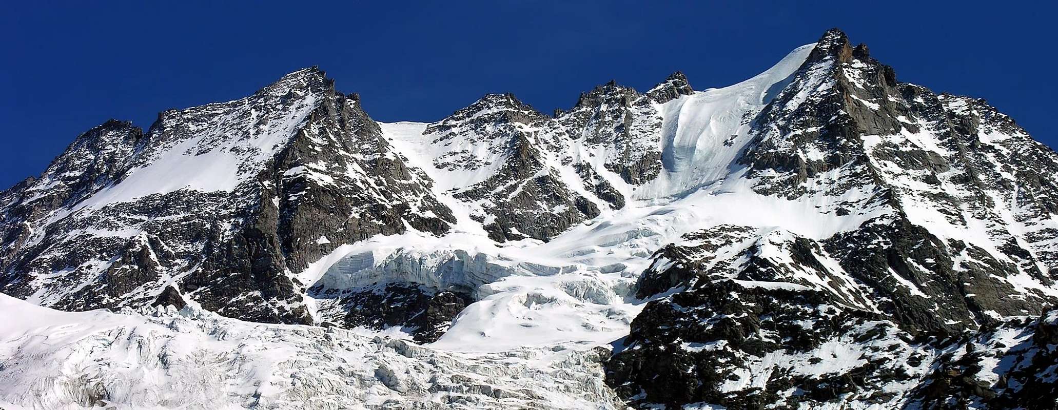
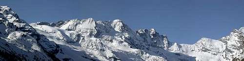
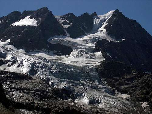
Roccia Viva 3.650m, gorgeous and mighty mountain in the Gran Paradiso Massif, is probably the only mountain that have a small lake on its summit, inside the edge of its snowy cap!The West-northwest Wall of the Roccia Viva is easily distinguishable from Valnontey by its frozen and dizzy northern wall with a huge hanging serac. On the other hand, it is not equally recognizable looking at it upwards, since its big ridges mingle in a shapeless heap of rocks and couloirs; only if one looks from a point just in front of it, its triangular form stands out, being included between the North-northwest Edge and the West-northwest big Ridge. In the middle of the face, on the left of a little but marked snowy conoid, a third large ridge, twin of the West-northwest large Ridge, rises parallel, bending towards left on high. Another less important ridge descends towards South-southwest on the Roccia Viva Glacier in the Piantonetto Walloon, accessible from Noaschetta Valley through the Colle della Losa; both Piantonetto and Noaschetta Valleys can be reached from Canavese (Piedmont).Roccia Viva is part of a big ridge: it is strictly joined with Becco della Pazienza and is delimited by Baretti (South) and Pazienza (East) Passes. Between Roccia Viva and Becco della Pazienza there are the two Summits named Gemelli di Roccia Viva (Roccia Viva Twins): Western Gemello (3.618m) and the Eastern (3.610m). These also have a nice and steep glacial facing North-northwest and which is already climbing on the in Western Twin, in July 25th, 1979 by Gianni Comino, Stefano De Benedetti and Gian Carlo Grassi. After a "mixed" route between the glacial North Wall and the Edge North-northwest by E. Pergameni and E. Stagno of July 14th, 1913 (!), repeated only once in July 1938), the climb integral and direct instead of the same was made by Giuseppe Delmastro and Carlo Pol August 23th, 1940 with a beautiful via that passes just to the right of the big serac hanging. The same, now somewhat reduced, and in the process of disappearing, has been increased from Carlo Pedenovi Guide Cogne Vincenzo Perruchon July 26th, 1971, exceeding by many nails and artificial climbing the great wall of those times. The Guides Abele Blanc and Pietro "Piero" Giglio with V. Bigio and L Castiglia have made the first winter ascent of this route the 7/8/9th January 1978. All other routes on ridges and walls are to be credited to famous names of the "Classic Mountaineering" as Ulrich Almer, Alessandro Emilio Martelli, Jean Joseph Maquignaz, Pietro Dayné, Ettore Canzio, Felice Mondini, Nicola Vigna, Giacomo Dumontel, E. Danesi, E.K. Esslinger, Adolf and Alfred Aufdenbatten, Pietro Pompeo Viglino, Franz Gardiner, the famous Reverend New York Wuilliam Augustus Brevoort Coolidge and others. Worth a special mention the first winter ascent of Don Piero Solero with Leopoldo Saletti and P. Piccio February 9th, 1939 by the Piedmont side through the great rocky couloir East-southeast. As regards the way described here, it has been realized for a "youthful error" in July 1968 by Osvaldo Cardellina, Sergio Spinaci e Giuseppe "Pino" Trevisan through a good direct via on rotten but enough good rock. The notice out on the ridge just to the right of the route 161c, on the sketch number 43 on page 395 of the Guide C.A.I./T.C.I. "Gran Paradiso National Park" by Emanuele Andreis, Renato Chabod and Mario Carlo Santi; Editions in 1939, 1963 and 1980.
La Roccia Viva (3.650 m), é montagna splendida e possente sita nel Massiccio del Gran Paradiso, ed è probabilmente l'unica Vetta a possedere un laghetto sulla sua Sommità, all'interno d'una mini conca glaciale! Il Versante Settentrionale della medesima è facilmente distinguibile ed osservabile dalla Valnontey per la sua ghiacciata Parete Nord, caratterizzata da un'enorme seracco pensile. Mentre quella Nordoccidentale non è altrettanto ben distinguibile, in quanto le sue grandi creste si confondono in un insieme decisamente informe di creste rocciose e canaloni; solo osservando in modo decisamente frontale, con la sua forma largamente triangolare, va evidenziandosi distinguendosi in modo nitido e chiaro, essendo compresa tra lo Spigolo Nord-nordovest ed il Crestone Ovest-nordovest. Al centro della parete, affianco ad una piccola, ma marcata, conoide innevata che la risale per breve tratto, un terzo grande crestone, gemello della grande Cresta Ovest-nordovest, s'innalza parallelamente, flettendo sulla sinistra verso l'alto. Un'altra cresta ancora, meno importante o perlomeno meno lunga, scende verso Sud-sudovest sul Ghiacciaio della Roccia Viva nel Vallone del Piantonetto, accessibile dalla Valle di Noaschetta attraverso il Colle della Losa; sia quello di Piantonetto che quello di Noaschetta sono raggiungibili dalla Valle dell'Orco in Canavese (Piemonte). La Roccia Viva è facente parte d'una grande cresta, infatti risulta "legata" al vicino Becco della Pazienza che è delimitato ad Oriente dal Colle della Pazienza ed all'opposto, o Sud-sudovest, dal più viciniore Colle Martino Baretti. Tra Roccia Viva e Becco della Pazienza si collocano le due piccole Sommità dette Gemelli della Roccia Viva: l'Occidentale (3.618m) ed il Gemello Orientale (3.610m). Anche questi presentano una bella e ripida parete glaciale rivolta a Nord-nordovest e peraltro già salita, sul Gemello Occidentale, il 25 di Luglio del 1979 da Gianni Comino, Stefano De Benedetti e Gian Carlo Grassi. Dopo una via "mista" tra la glaciale Parete Nord e lo Spigolo Nord-nordovest da parte di E. Pergameni ed E. Stagno del 14 Luglio 1913 (!), ripetuta un'unica volta nel Luglio del 1938, la salita integrale e diretta della stessa invece era stata realizzata da parte di Giuseppe Delmastro e Carlo Pol i 23 Agosto 1940 con una bella via che passa subito a destra del grande seracco pensile. Lo stesso, oggi alquanto ridotto ed in via di scomparire, é stato salito da Carlo Pedenovi con la Guida di Cogne Vincenzo Perruchon il 26 Luglio 1971, superando con molti chiodi ed arrampicata artificiale il grande muro esistente allora. Le Guide Abele Blanc e Pietro "Piero" Giglio insieme a V. Bigio e L. Castiglia hanno realizzato la prima invernale di questo percorso il 7/8/9 Gennaio 1978. Tutti gli altri itinerari su creste e pareti sono da accreditare a nomi famosi dell'"Alpinismo Classico" come Ulrich Almer, Alessandro Emilio Martelli, Jean Joseph Maquignaz, Pietro Dayné, Ettore Canzio, Felice Mondini, Nicola Vigna Giacomo Dumontel, E. Danesi, E.K. Esslinger, Adolf e Alfred Aufdenbatten, Pietro Pompeo Viglino, Franz Gardiner, il celeberrimo Reverendo di New York Wuilliam Augustus Brevoort Coolidge ed altri ancora. Merita citazione particolare la prima salita invernale di Don Piero Solero con Leopoldo Saletti e P. Piccio il 9 Febbraio 1939 dal lato piemontese tramite il canalone Est-sudest. Per quanto concerne la via qui descritta, essa é stata realizzata per un "errore giovanile" nel Luglio 1968 da parte di Osvaldo Cardellina, Sergio Spinaci e Giuseppe "Pino" Trevisan con una bella via diretta su roccia rotta ma abbastanza buona. Si evidenzia sulla cresta subito a destra dell'itinerario 161c, sullo schizzo n° 43 pag. 395 della Guida C.A.I./T.C.I. "Gran Paradiso Parco Nazionale" di Emanuele Andreis, Renato Chabod e Mario Carlo Santi; Edizioni del 1939, 1963 e 1980.
First Ascents
First on the summit: A. E. Martelli, J.J. Maquignaz and S. Meynet, (Jul 05th, 1874).
In winter: Don P. Solero L. Saletti and P. Piccio, (Feb 09th, 1939).
W Slope and S-SW Crest: A. E. Martelli, J.J. Maquignaz and S. Meynet, (Jul 05th, 1874).
S-SW Crest (entirely): E. Canzio, F. Mondini and S. Meynet, (Aug 21th, 1894).
W-NW Arête: Missis H. Kunze, Mr. Barthelett and P. Dayné, (Jul 1905).
W-NW Arête (Variant from the glacier): G. and C. Andreoni, G. Bevione with Mountain Guide Cogne C. Gerard, (Aug 26th, 1906).
W-NW Couloir: L. Ambrogi, F. Canzanella, P. Monaco and A. Spera, (Aug 02th, 1954).
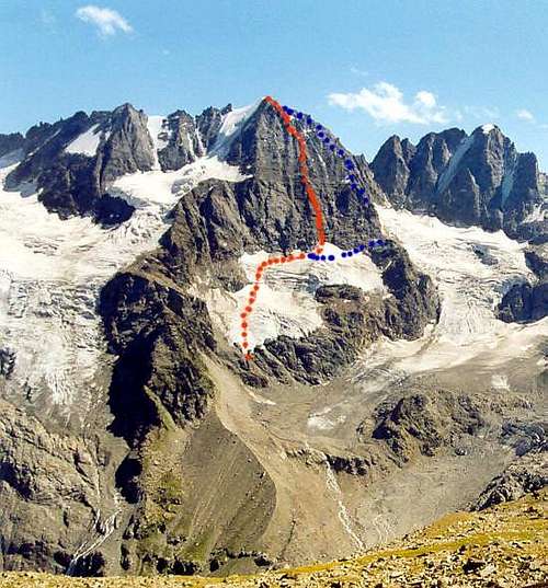
W-NW Eperon: O. Cardellina, S. Spinaci and G. Trevisan, (Jul 21th, 1968).
N-W Wall: E. Danesi and E. K. Esslinger, (Aug 03th, 1926).
N-NW Edge: S. L. Courtauld, E. G. Oliver, Ad. and Alf. Aufdenblatten, (Sep 01th, 1921).
N Wall and N-NW Edge: F. Pergameni and E. Stagno, (Lug 14th, 1913).
N Wall (direct): Giuseppe Delmastro and Carlo Pol, (Aug 23th, 1940).
N Wall (Serac Via): Carlo Pedenovi and Vincenzo Perruchon, (Jul 26th, 1971).
E-SE Couloir and E-NE Ridge: W.A.B. Coolidge and F. Gardiner with swiss Mountain Guides Chr. junior Almer and R. Almer, (Aug 17th, 1887).
E Slope and S Edge: A. Treves, A. Verona, P. Viglino with Mountain guide Valtournanche S. Meynet, (Jul 22th, 1907).
S Wall: J.P. Baker, U. Almer and J. Jossi, (Aug 10th, 1881).
Getting There
BY CAR:
Coming from France through the Mont Blanc tunnel or the Col du Petit St. Bernard-use the autoroute till Aosta Ovest or the road SS n° 26 till the junction near Sarre.
Coming from Italy - use the autoroute till Aosta Ovest. Then, after Aymavilles enter in the valley southward and after Vieyes, Epinel and Cretaz Villages in 25 km you get Cogne (1.534m).
From Cogne, by bus or by car, till to Valnontey (1.666m)
BY PLANE:
Aeroporto "Corrado Gex" Saint Christophe (Aosta).
Approach to southern valleys (Piantonetto and Noaschetta)
coming from Torino - autoroute to Aosta - till to S. Giorgio Canavese or take the road SS.460 to Ceresole Reale. When you arrive at Rosone Village (16 km to Pont Canavese) take a little road on the right, see the sign "Piantonetto Valley". Go as far as the end of the carriage road at Teleccio Lake (1.870m), and park your car.
Approach
From Valnontey little Hamlet (1.666m) follow the path n° 22 till to the alternative at (2.040m); 1h'15/2h'00); give up the right branch leading to all the other bivouacs of the area, turn left instead and follow the signs, through the path n° 22E, till to the Bivouac Alessandro Martinotti (2.588m), not visible during the ascent (2h'30/3h'00). From the bivouac descend briefly and climb again along the pretty steep lateral moraine and the Northern limit of the Roccia Viva Hanging Glacier, then turn South gradually, through a slope of about 32°/35°, to pass on a rocky islet and a serac near an evident snowy conoid at the foot of an enough wide gorge (1h'15/2h'00).
Da Valnontey (1.666 m) seguire il sentiero n° 22 fino al bivio (2.040 metri; 1h'15/2h'00); scartare il ramo di destra conducente a tutti gli altri bivacchi della zona; svoltare invece a sinistra seguendo le indicazioni, tramite il il sentiero n° 22E, fino al Bivacco Alessandro Martinotti (2.588 m), non visibile durante la salita (2h'30/3h'00). Da questo scendere brevemente e risalire lungo la morena e il limite Settentrionale del Ghiacciaio Sospeso di Roccia. In seguito girare gradualmente verso Sud, tramite un pendio di circa 32°/35°, passando su di un isolotto roccioso e un seracco in prossimità d'una evidente conoide nevosa ai piedi di una evidente nonché abbastanza larga gola (1h '15/2h'00).
Route
At the beginning of this glacial feature alluvial fan, get over the crevasse on the left (upward) against the rocks and, after have climbed the first 100 meters along the split between the rocks and the ice, turn resolutely on the large ridge rising in the centre of the wall; in the beginning the form of the ridge is stocky, then becomes progressively thinner. In this initial section must be careful to possible falling rocks. Climb for other about 300 meters along stepped greysh rocks more difficult and enough challenging (II°/II°+/III°-). Afterwards, when the ridge become bent to left with the further insertion of two lateral secondary ridges, the rock changes its form and colour, becoming remarkably better. Through reddish and more compact slabs (II°+, III°-/III°) overcome keeps and vertical walls along approx. 100 meters till to reach the South-southwest Crest, through a brocken rocks with detritic ground, just at the Top where, in a small basin, there was a characteristic tiny and icy lake (5h'00/7h'00 from the beginning).
Downhill: along the West-northwest large Ridge (Standard Via), going down more southerly. Be very careful in research of the route since there are no signals.
In the shadow the W-NW Wall and outline to the right the Standard Via.
All'inizio di questa ben caratterizzata conoide glacilale, superare il crepaccio sulla sinistra in alto contro le rocce e, dopo aver scalato i primi 100 metri lungo la spaccatura tra le rocce e il ghiaccio, accedere risolutamente sulla grande dorsale che sorge nel centro della parete; all'inizio la forma della cresta è piuttosto "robusta" quindi diventa progressivamente più esile e slanciata. In questo tratto iniziale bisogna fare molta attenzione alla possibile caduta di pietre. Salire per altri 300 metri circa tramite rocce grigiastre a gradini più difficili ed abbastanza impegnative (II°/II°+/III°-). In seguito, quando la cresta flette sulla sinistra ed affiancata lateralmente da ulteriori due speroncini secondari, la roccia cambia sia di forma che di colore, diventando rossastra e decisamente migliore nonché maggiormente compatta. Attraverso lastroni rossicci (II°+, III°-/III°) superare una successione di muretti più o meno verticali lungo all'incirca un centinaio di metri fino a raggiungere la Cresta Sud-sudovest, attraverso un terreno più frantumato con rocce rotte e detrito, proprio nelle vicinanze del Vertice, ove, in una piccola conca glaciale, s'evidenzia un caratteristico laghetto ghiacciato (5h'00/7h'00 dall'inizio).
Discesa: lungo il Crestone Ovest-nordovest (Via Normale), scendendo più a Sudovest. Prestare molta attenzione nella ricerca della via, poiché non esistono segnalazioni.
Difficulties
The route is classified AD.
La via é da classificarsi come AD.
Equipment
Mountaineering equipment, including rope, ice axe, and crampons.
Da alpinismo, con corda, piccozza e ramponi.
Huts
From Cogne:
Bivacco Alessandro Martinotti (2.588m).
Bivacco Stefano Borghi (2.686m).
Campings
Wild camping in the Parco Nazionale del Gran Paradiso is strictly forbidden!!!There are three camping sites very near to Valnontey village.The most appropriate support point is the Martinotti and Borghi bivouac.
Mountain Condition
Meteo: you can find all the needed informations at the official site of the Valle d'Aosta Region:
"Guida delle Alpi Occidentali" di Giovanni Bobba e Luigi Vaccarone C.A.I. Sezione di Torino Volume II (parte II), 25 Maggio 1896.
"Guida dei Monti d'Italia-Gran Paradiso Parco Nazionale" E. Andreis, R. Chabod, M. C. Santis, Club Alpino Italiano/Touring Club Italiano, prima Ed. 1939; seconda Ed. 1963; terza Ed.
G. Berutto "Il Parco Nazionale del Gran Paradiso" III°, volume 2° Ed. I.G.C. Torino 1981, 2000.
"Diari Alpinistici" di Osvaldo Cardellina e Indice Generale accompagnato da Schedario Relazioni Ascensioni 1964-2019 (inediti).
"80 itinerari di Escursionismo Alpinismo e Sci Alpinismo in Valle d'Aosta", di Osvaldo Cardellina, Ed. Musumeci, Giugno 1977 (in Italian); seconda Ed. Luglio 1981; terza Ed. Luglio 1984; (in French), prima Ed. Febbraio 1978; seconda Ed. Marzo 1980.
A. Gegenfurtner, G. Klotz, F. Müller "Gran Paradiso", Ed. Bergverlag Rudolf Rother, Monaco 1980 (in tedesco).
G. Klotz "Gran Paradiso" Ed. Bergverlag GmbH Rother, Monaco 2005 (in tedesco).
MAPS:
Kompass "Gran Paradiso Valle d'Aosta" Sentieri e Rifugi Carta turistica 1:50.000.
I.G.C. Istituto Geografico Centrale "Gran Paradiso La Grivola" Carta 1:25.000.
L'Escursionista "Valle di Cogne Carta dei Sentieri" (n° 10) 1:25.000.
L'Escursionista "Tour de la Vallée de Cogne Grand Paradis" Carta dei sentieri 1:25.000.
I.G.C. Istituto Geografico Centrale "Il Parco Nazionale del Gran Paradiso" 1:50.000.
I.G.M. Istituto Geografico Militare Foglio 41 I SO Gran Paradiso - I NE Cogne 1:25.000.
Enrico Editore Ivrea "Gruppo del Gran Paradiso" 1:50.000.
Studio F.M.B. Bologna "Gran Paradiso" 1:50.000.
Red Tape
Inside the borders of the P.N.G.P. (Parco Nazionale del Gran Paradiso), at the moment (summer 2004) dogs generally are not allowed, except a pair of paths, and free camping is forbidden (except for climbers from sunset till dawn). No fees are due.
Children refers to the set of objects that logically fall under a given object. For example, the
Aconcagua mountain page is a child of the 'Aconcagua Group' and the 'Seven Summits.' The
Aconcagua mountain itself has many routes, photos, and trip reports as children.
Parents refers to a larger category under which an object falls. For example, theAconcagua mountain page has the 'Aconcagua Group' and the 'Seven Summits' asparents and is a parent itself to many routes, photos, and Trip Reports.

 19812 Hits
 94.24% Score
 46 Votes