-
 10437 Hits
-
 83.69% Score
-
 17 Votes
|
|
Mountain/Rock |
|---|---|
|
|
45.90000°N / 7.00481°E |
|
|
Aosta - Haute Savoie, France/Italy, Europe |
|
|
Mountaineering |
|
|
12238 ft / 3730 m |
|
|
Overview
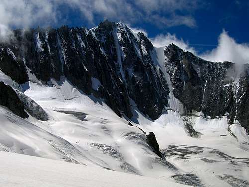
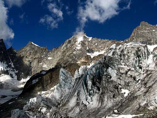
Bulky and stocky pyramid shaped mountain on the boundary between Italy and France, situated on the ridge between the "Col Pierre Joseh (3.478m)" and the "Col Savoie (3.491m)", almost in the middle between Aiguille de Leschaux and Aiguille de Triolet. It doesn’t look especially sharp from any sides, if compared to the elegant neighbours. It overhangs the glacier of Triolet with a huge buttress that divides the Italian side in 2 parts: the eastern with middle inclination and snow slopes mixed to broken rocks; while the southern side is steeper and rocky. On the French side it has two walls: one is orientated to south-west that overhangs the glacier "Pierre Joseph" and plowed from two snowy gorges; the other more imposing and severe is orientated to north-west and stand above the glacier of Talèfre and carved from numerous ice couloirs. The summit is composed from a rocky crest long 60m that connects two different peaks: NE (3.730m) which is the highest point and, SW (3.726m). The one on SW despite is the lowest, is topographically the most important because is the begin of the crest that divides the basins Leschaux and Talèfre. The structure is composed mainly from rock of low quality especially on the Italian side, and it is commonly climbed more for the spacious panorama that for climb interest. Anyway it’s rarely climbed. Another interesting summits on its west ridge are also the "Petit Aiguille de Talèfre (3.615m)" and the "Aiguilles Pierre Joseph (3.472m, 3.414m)"


First Ascents
-
First ascent: F. J. Cullinam, G. Fitzgerald, Emile Rey, Joseph Moser and Laurent Lanier, (Aug 25th 1879).
Getting there and refuges
From Italy: As the other summits of this part of Mont Blanc group, the startig point is the Val Ferret above the village of Courmayeur (Aosta valley), and the huts that serves this basin is the refuge Dalmazzi al Triolet.
Refuge Dalmazzi (2.559m): From the village of Courmayeur, follow by car the paved road until the hamlet called Arnouva (1.769m). From there take the path n° 23 in 2 hours to the refuge Dalmazzi, basecamp for all the routes in the Triolet basin. Refuge Dalmazzi is a small and cozy hut with 30 places open from the end of june to the end of September. Tel-0165/869098
From France: The huts that serve this area on the French side are the “refuge de Leschaux (2.431m)” for who want to get the glacier Pierre Joseph and “refuge du Couvercle (2.687m)” for the glacier de Talèfre. Both reachable from Chamonix with a long journey. First by a train from the rail station to “Montenvers” (1.909m).
Refuge du Couvercle (2.687m): From Montenvers get down by ladders to the base of the glacier. Walk easily on the flat glacier until it divides itself in two. On the cliff on your left side, same jellow signals (visible from far) indicate the numerous iron ladders that takes to the base of the Aiguille du Moine where the hut is placed. (3h'00/3h'30 hours from Montenvers). Open from mid june to mid September-130 places-tel. +33/450531694
Refuge de Leschaux (2.431m): From Montenvers get down and follow the same route to the refuge du Couvercle. When the glacier divides in two, follow the left branch (glacier de Leschaux) pointing the foot of the Grandes Jorasses north wall. Before the glacier increase in steep the small hut should be visible on a rocky wall more or less 80m above the glacier (your left). Same ropes helps to approach. (3h'30/4h'00 hours from Montenvers). Open from mid june to mid September-24 places-tel. +33/686123149
Wide view of Triolet basin

Routes
The mountain covers 3 basins:
|
From Triolet basin (Italy): Refuge Dalmazzi East ridge - Most logic route from this side – AD South/east ridge - Interesting but longer that previous – PD+ South/south/east ridge - Easy but bad quality rocks, not recommended – PD
|
|
From glacier "Pierre Joseph" (France): Refuge de Leschaux South/west flank - French normal route – PD West ridge - Very interesting – AD
|
|
From Talèfre basin (France): Refuge du Couvercle North/west flank - Very nice icy couloir 50°/60° - D+ North/west flank - “Davaille route" 55°/60° - TD North/west flank - “Goulotte Gabarrou 1978" 75° - D+ North flank - “Voie Dufour” 80° - TD-
|
Campings
Remember that free camping is forbidden (except for emergency reasons, over 2.500m, from darkness until dawn).
Mountain Conditions
- You can get meteo information at the official site of the Regione Valle d'Aosta:
- Valle d'Aosta Meteo
Webcam
- WEBCAM on Aosta Valley:
- Webcam
Books and Maps
BOOKS:
- "Guida delle Alpi Occidentali", di Giovanni Bobba e Luigi Vaccarone C.A.I. Sezione di Torino Volume II (parte II), 25 Maggio 1896.
- "Guida dei Monti d'Italia-Monte Bianco" (Vol.II°) di R. Chabod, L. Grivel, S. Saglio, G. Buscaini-Club Alpino Italiano/Turing Club Italiano, 1968 (in Italian).
- "I Rifugi della Valle d'Aosta" di Stefano Ardito, Ed. Guide iter, Febbraio 2003.
- "A piedi in Valle d'Aosta" (Vol.1), di Stefano Ardito, Ed. Guide iter, Giugno 2003.
- "80 itinerari di Escursionismo Alpinismo e Sci Alpinismo in Valle d'Aosta", di Osvaldo Cardellina, Ed. Musumeci, Giugno 1977 (in Italian); seconda Ed. Luglio 1981; terza Ed. Luglio 1984; (in French), prima Ed. Febbraio 1978; seconda Ed. Marzo 1980.


- Kompass "Massiccio del Monte Bianco Valle d'Aosta Sentieri e Rifugi" Carta turistica 1:50.000.
- I.G.C. Istituto Geografico Centrale Torino "Massiccio del Monte Bianco" (n° 4), Torino, 1998 1:50.000.
- I.G.C. Istituto Geografico Centrale Torino "Monte Bianco-Courmayeur-Chamonix-La Thuile" (n° 107), 1:25.000.
- L'Escursionista "Monte Bianco Courmayeur" (n° 1) Edizioni Rimini 2004 1:25.000.
- Edizioni Tabacco "Mont Blanc" Udine, 1978 1:50.000.
- Studio F.M.B. Bologna 1988 "Monte Bianco-Mont Blanc" 1:50.000.
Important Information
- REGIONE AUTONOMA VALLE D'AOSTA the official site.
- FONDAZIONE MONTAGNA SICURA Villa Cameron, località Villard de la Palud n° 1 Courmayeur (AO) Tel: 39 0165 897602 - Fax: 39 0165 897647.
- Società Guide Alpine Courmayeur www.Guidecourmayeur.com - Strada Villair n° 2 - 11013 Courmayeur (Aosta) Italy - Tel. +390165842064 Fax. +390165842357 - P.I. 01022640070
- A.I.NE.VA. (Associazione Interregionale Neve e Valanghe).
Useful numbers
- Protezione Civile Valdostana località Aeroporto n° 7/A Saint Christophe (Ao) Tel. 0165-238222.
- Bollettino Meteo (weather info) Tel. 0165-44113.
- Unità Operativa di Soccorso Sanitario Tel. 118.


