
-
 27332 Hits
-
 96.81% Score
-
 63 Votes
|
|
Mountain/Rock |
|---|---|
|
|
45.49320°N / 7.24754°E |
|
|
Mountaineering |
|
|
11949 ft / 3642 m |
|
|
Overview
First Ascents
- In the Summit: F. Vallino, A. Blanchetti, (Aug 25th, 1871).
- First Winter: G. Jarre and B. Martinazzi, (Dec 30th, 1941).
- First by Ski: P. Preuss, (1913).
- SW Ridge: F. Vallino, A. Blanchetti, (Aug 25th, 1871).
- W Wall: F. Gonella with G. Blanc and F. Daynè, (Jul 29th, 1885).
- W-NW Ridge (Alternatives route): A. Lucchetti, M. Frassinelli, (Aug 08th, 1918).
- NW Ridge: D. Escoffier, O. De Falkner, (Aug 29th, 1894).
- Alternatives routes:
- G. Bobba with C. Therisod and G. Noro, (Sep 26th, 1894).
- M. Corte, M. Costa, V. Ferrero, A. Viriglio, (Aug 19th, 1920).
- N Wall between "Icecap Wall" NW Ridge Probably done by Guarducci in July 1880.
The first documented ascent was done here by E. Allegra, U. Sandrinelli and P. Daynè, (Jun 24th, 1902). - N Wall (Central Route or "Way of Serac", which no longer exists): Giacomo and Enrico Chiara, Enrico Cattinelli, (Jul 02-03th, 1939).
- Alternatives routes:
- (Left Bastion): A. Barberis et al. (Aug 07th, 1941).
- (Left Rampart and Ice Cap Edge) V. Epis, L. Perin, E. Regazzi, (Sep 23th, 1966).
- Angelo Bozzetti Via (N-NE Dihedral and N-NE Face), (Aug 08th, 1962).
- NE Ridge: W. A. B. Coolidge, C. Almer, R. Almer, (Aug 14th, 1888).
- E Wall : A. Bonacossa, A. Sarfatti (Jul 20th, 1923).
- SE Ridge: E. H. F. Bradby, C. Wilson with E. Rey, (Jul 10th, 1897).
- S Wall : G. Bertarelli, A. Bonacossa, C. Prochownik, (Aug 20th, 1920).
- S Wall (Right triangular sector under the great Shoulder just below the Top): Osvaldo Cardellina, lone, (Aug 04th, 1981); in ascent in day from Pont, Vittorio Emanuele Shelter, Montcorvé and Monciai Glaciers, Collle del Ciarforon; in descent by NW Ridge to Montcorvé Glacier and shelter.
- S Wall (Rocky couloir on Left sector): Tommaso Giorda and Giorgio Viano, (Seventies); in descent to Broglio Glacier.
- Data collected by livioz from:
- Guida dei Monti d'Italia - Gran Paradiso Parco Nazionale Club Alpino italiano/Touring Club Italiano (1980).
- N Wall (Right Route): I. A. Garzotto and O. Cardellina, (Jul 16th, 1967).
- S Wall (Mini Couloir): I. A. Garzotto and O. Cardellina (Jul 16th, 1967).
- N Wall (Central Direct Route): O. Cardellina, G. Lamazzi, C. R. Ferronato and G. Gadin, (Jul 11th, 1979); in day from Pont Valsavaranche. * I° Repetition: O. Cardellina, B. Pieiller and U. Brunier, (Jul 18th, 1980); in day from Pont Valsavaranche.
- From: "Mountain Diaries" 1964-69 by Ilario Antonio Garzotto & 1964-2021 by Osvaldo Cardellina.
 |
 |
 |
 |
 |
Overview
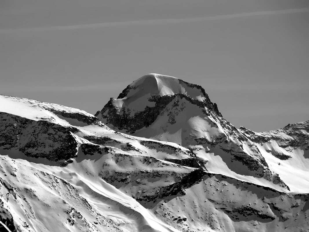
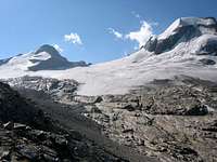
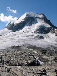
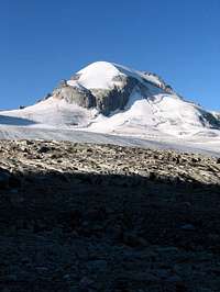
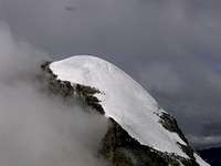
Ciarforon is an unmistakeable dome-shaped summit belonging to the Gran Paradiso Group. It is easily recognizable from everywhere in the distance. It lies south of the Gran Paradiso Summit, between La Tresenta (3.609m) and Becca di Monciair (3.544m), along the watershed between Valsavarenche and Valle dell'Orco. Its ice cap is unbelievably large and once accomodated a small lake (in summer, obviously!), like the Summit of the nearby Roccia Viva. In addition to the ice cap (3.642m, but in the distant 1881 its height had been estimated to be (3.657m)) there is a second rocky summit, where a sign is placed, at an elevation of (3.642m).
Ciarforon is separated from La Tresenta by Colle di Moncorvè (3.294m) and from Becca di Monciair by Colle del Ciarforon (3.317m); near the last one there is also another saddle at (3.333m), lacking an official name, but called in some places Colle di Monciair. This saddle should not be confused with the southerner Colletto di Monciar (3.297m), between Becca di Monciair and Denti del Broglio (also called Cima di Breuil). Ciarforon is surrounded by four glaciers: Moncorvè (North),Ciamousseretto (East), Breuil (South), and Monciair (West). In the past it was almost completely covered by the upper part of the Moncorvé Glacier, but in recent years it has undergone a powerful diet and its aspect has dramatically changed.
On the S side (Vallone di Piantonetto) Ciarforon takes on a quite different aspect, showing a rocky wall up to 300 meters tall. The summit commands rather nice closeup views of many summits of the Gran Paradiso Group, including the impending main summit (4.061m), as well as background views of Rutor, La Grande Sassière and, of course, Mont Blanc.
 |
 |
 |
 |
 |
Il Ciarforon è una Sommità, più che a vertice, a forma di cupola inconfondibile appartenente al Gruppo del Gran Paradiso. E' facilmente riconoscibile da ovunque in lontananza. Trovasi subito a Sud della Vetta del Gran Paradiso, tra La Tresenta (3.609 m) e la Becca di Monciair (3.544 m) nonché lungo lo spartiacque tra Valsavarenche e la Valle dell'Orco. La calotta di ghiaccio è (nei tempi passati alquanto di più) incredibilmente grande e una volta ha contenuto un laghetto (in estate, ovviamente!), parimenti al vertice della vicina Roccia Viva. Oltre al calottone glaciale (3.642 m, ma nel lontano 1881 la sua altezza era stata stimata in 3.657 m) esiste una seconda cima rocciosa, dove si trova un segnale (grande tumulo in pietra), ad un'altitudine di (3.642 m).
Il Ciarforon è separato da La Tresenta dal Colle di Moncorvè (3.294 m) e dalla Becca di Monciair dal Colle del Ciarforon (3.317 m); vicino all'ultimo c'è anche un altra selletta (3.333m), in mancanza d'un nome ufficiale, ma é ormai riconosciuta come Colle di Monciair. Questa sella non deve essere confusa con il Colletto Meridionale di Monciar (3.297 m), tra la Becca di Monciair ed i tre Denti del Broglio (complessivamente detta anche Cima di Breuil). Il Ciarforon è circondato da quattro ghiacciai: Moncorvé (Nord), Ciamousseretto (Est), Breuil (Sud), e Monciair (Ovest). In un recente passato è stato quasi completamente ricoperto dalla parte superiore del Ghiacciaio Moncorvé, ma negli ultimi anni ha subito una notevole riduzione ed il suo aspetto ne è uscito drasticamente cambiato.
Sul lato Sud (Vallone di Piantonetto) il Ciarforon assume un aspetto del tutto diverso mostrando una parete rocciosa alta fino a 300 metri. Dal vertice offresi una bella vista di primo piano su di molte Vette del Gruppo del Gran Paradiso, inclusa la vicina cima principale (4.061 m), oltre a una vista di sfondo su Rutor, Grande Sassière e, naturalmente, verso il Monte Bianco.
Getting There
- From France: through the Mont Blanc Tunnel or the Col du Petit Saint Bernard:
you can drive on SS.26, following directions for Aosta and, before arriving in Villeneuve, turn right towards Introd.
Alternatively, you can take Motorway A5 (at Courmayeur or Morgex) and exit at Aosta Ovest. - From all the other directions:
get to the Aosta Ovest exit of Motorway A5. Then drive on SS.26 Aosta, in the direction of Courmayeur; just after Villeneuve turn left towards Introd.
Shortly after Introd, you arrive at a junction: turn left, entering Valsavarenche, and passing through many villages (Degioz, Eaux Rousses, etc.) you can arrive at Pont (1.960m) where the road ends.The ascent to Ciarforon is usually done in two stages: on the first day you follow the normal route to Gran Paradiso and gain 770m of elevation from Pont (1.960m) to Rifugio Vittorio Emanuele (2.730m). The second day is spent on the climb to the summit.
 |
 |
 |
 |
 |
Standard Via (NE Ridge by Montcorvé Pass) & Variant on SW Face
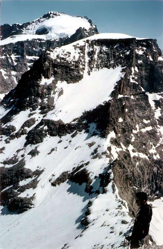
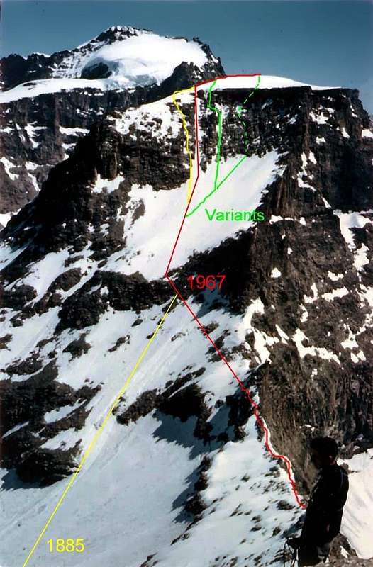
From the Rifugio Vittorio Emanuele, reached by Pont of Valsavarenche through the beautiful trail-mule track, overcome the "Torrent de Chanté" and Montcorvé reach the Glacier at an altitude of 2.900m~. Continue with the same direction East (danger crevasses) up to the terminal crevasses, generally closed at the start of the season. With the same route for the Northern Faceb and almost the same direction to reach of the Montcorvé Pass (3.299m). Overcome a rocky jump of about 80 meters (altitude 3.493 meters) is not difficult (I°+), but if exposed and delicate "verglass" Pass a gully that goes down to the Glacier Ciamuseretto and easy wire or keeping to the West on the rocky slope (33°/37°) to reach the Summit (3h'30/4h'00 AD+/D-). Pay Attention in ugly conditions (fresh snow or bright ice), the Northeast Ridge may be more difficult than the North Wall. Better of to go down to the Wall Southwest. On this was traced some routes starting from 1885 up to direct the gully between the two rock bands; in any case, do not forget that the wall is exposed to falling stones and that already have occurred as a deadly disasters in 1923 and 1946 (two mountaineers dead). From what episodes it is gone in progressive disuse and is only used as a way to "escape" for the above reasons. Definitely not recommended and surely better climbing on the Northeast Ridge, it is also used in combination, for other very rare, with the ascent of the nearby Becca di Monciair via the Normal Route (Northeast Ridge from Ciarforon Pass 3.317m) or for the "double" with the twin North Face (first in July 1967). In any case, after having dropped the first rock band to one of several existing routes (see photo below), should gradually move away from the wall to addressing Crest Southwest and so reaching the nearby Colle del Ciarforon.
 |
Dal Rifugio Emanuele con direzione Sudest attraversare il Torrent de Chantè e raggiungere il Ghiacciaio del Montcorvé a quota 2.900m~. Proseguire con la stessa direzione e attraversarlo tenendosi ad Est (crepacci) sino alle crepacce terminali, in genere chiuse ad inizio stagione. Con l'itinerario similare a quello per la Faccia Settentrionale e con la stessa direzione, raggiungere il Colle di Montcorvé (3.299 m). Superare un salto roccioso d'una ottantina di metri (quota 3.493m) non difficile (I°+), ma esposto e delicato se in "verglass" Superare un canalino che scende verso il Ghiacciaio di Ciamuseretto e sul facile filo roccioso, o tenendosi ad Ovest sul pendio meno ripido (33°/37°), raggiungere la Vetta (3h'30/4h'00 AD+/D-). Attenzione in cattive condizioni (neve fresca oppure ghiaccio vivo) la Cresta Nordest può essere più difficile della stessa Parete Nord. Conviene allora scendere per la Parete Sudovest. Su questa sono state tracciate alcune vie a partire dal 1885 fino a quella diretta sul canalino in mezzo alle due fasce rocciose nel 1967; in ogni caso da non dimenticarsi che la parete risulta esposta a cadute di pietre e che già si sono verificate disgrazie mortali come nel 1923 e nel 1946 con due morti. Da quegli episodi é andata in progressivo disuso ed utilizzata solo come via di "fuga" per i motivi suddetti. Sicuramente meno consigliabile della Cresta NE, rimane inoltre utilizzata per la combinazione, per altro assai rara, con la salita della vicina Becca di Monciair tramite la Via Normale (Cresta Nordest dal Colle del Ciarforon 3317m) oppure per la "doppietta" con la gemella Nord (prima nel Luglio 1967). In ogni caso, discesa la prima fascia rocciosa per uno dei vari percorsi esistenti (vedi foto sopra), conviene allontanarsi progressivamente dalla parete indirizzandosi alla base laterale della Cresta Sudovest e così raggiungendo il vicino Colle del Ciarforon.
Some details on the other routes (North Face)
North Face is definitely the one that best identifies this mountain path busiest is to Gonella-Blanc-Dayné of July 1885, while the other routes on the left have not yet been repeated. A separate deserves the Via brothers Chiara-Cattinelli of July 1939 that, after being in vogue until the end of the Sixties, is then fall in anonymity because of the disappearance of the big serac. As regards the other walls (East 1923 South 1920 and West 1885) to be detected as the first two have known a single ascent, while as regards the last, the considerations above. Not unlike the speech against the four ridges existing in fact, apart from the Crest Northeast or Normal Route, others have fallen by the wayside or almost: the Crest Southwest from Colle del Ciarforon or via the first climbers in practice is no longer covered if not with workarounds, as already mentioned, on the Face West; the Southeast of July 1897, made up of good rock, probably has been repeated, with a more complete itinerary, by Maria and Emmanuel Andreis with Renato Chabod 16th July 1936. deserves more attention, because, according to the latter, it is similar to the Normal Route of Petit Dru; same fate for the Northwest Ridge of August 1894 that, repeated in 1911 by Irving, Mallory and Companions, he met a certain attendance often due to bad conditions ("verglass") of the North Wall. The modern equipment and the technique traction-piolet have solved this problem, and the crest has been almost completely forgotten. Unfairly. Via Angelo Bozzetti (large dihedral) was attempted on July 22th 1967 by Ilario Antonio Garzotto and Renato Quendoz, but the attack is no longer possible due to a huge crevasse.

NORTH WALL
Elevation gain: 400m
Difficulty: AD+
glacier ascent with average angle of 45°-50°
the summit couloir reaches 65°
Time required: 4-5 hours (from Ref. Vittorio Emanuele II°)
Sicuramente la Parete Nord é quella che meglio identifica questa montagna: il percorso più frequentato risulta quello di Gonella-Blanc-Dayné del Luglio 1885, mentre le altre vie più a sinistra non sono state ancora ripetute. Un discorso a parte merita la Via dei fratelli Chiara-Cattinelli del Luglio 1939 che, dopo essere stata in auge fino al termine degli Anni Sessanta, é poi caduta nell'anonimato a causa della scomparsa del grande seracco. Per quanto concerne le altre pareti (Est 1923, Sud 1920 ed Ovest 1885) da rilevare come le prime due abbiano conosciuto un'unica salita, mentre per quanto riguarda l'ultima valgono le considerazioni di cui sopra. Non molto dissimile il discorso nei confronti delle quattro creste esistenti infatti, a parte la Cresta Nordest o Via Normale, le altre sono cadute nel dimenticatoio o quasi: la Cresta Sudovest dal Colle del Ciarforon o via dei primi salitori in pratica non viene più percorsa se non con aggiramenti, come già detto, sulla Faccia Ovest; quella Sudest del Luglio 1897, formata da ottima roccia, probabilmete é stata ripetuta, con un itinerario più integrale, da parte di Maria ed Emanuele Andreis con Renato Chabod il 16 Luglio 1936. Merita più attenzione, poichè, a detta di quest'ultimo, risulta similare alla Via Normale del Petit Dru; stessa sorte per la Cresta Nordovest dell'Agosto 1894 che, ripetuta nel 1911 da Irving, Mallory e Compagni, ha conosciuto una certa frequentazione spesso dovuta alle cattive condizioni ("verglass") della Parete Nord. La moderna attrezzatura e la tecnica del piolet-traction hanno risolto questo problema e la cresta é stata dimenticata quasi del tutto. Ingiustamente. La Via Angelo "Angelino" Bozzetti (grande diedro) é stata tentata il 22 di Luglio del 1967 da parte di Ilario Antonio Garzotto e Renato Quendoz, ma l'attacco é divenuto impossibile a causa d'una crepaccia terminale enorme.
Red Tape
There are no fees or permits. Parking in Pont, at the start of the route to Vittorio Emanuele II Refuge, is free and there are no limitations for climbing and hiking.
Remember that free camping is forbidden (except for emergency reasons, over 2.500m, from darkness until dawn).
The whole region is part of the Parco Naturale del Gran Paradiso and thus you should take care of nature as usual within the boundaries of natural parks.
 |
 |
 |
 |
 |
When To Climb
The best time is obviously July through September. Most ascent routes to the summit include glaciers so you need crampons anyway.
 |
 |
 |
 |
Huts
Accomodations can be found in all villages of Valsavarenche. You can use Rifugio Vittorio Emanuele as base for the ascents to both Gran Paradiso and Ciarforon. In addition there are several campgrounds in Valsavarenche, one of which just near the trailhead .
 |
 |
 |
 |
Campings
- Wild camping in the Parco Nazionale del Gran Paradiso is strictly forbidden!!!
Mountain Conditions
- Meteo: you can find all the needed informations at the official site of the Valle d'Aosta Region:
Valle d'Aosta Meteo
Webcam
- WEBCAM on Aosta Valley:
- Webcam
Books and Maps
BOOKS:
- "Guida delle Alpi Occidentali" di Giovanni Bobba e Luigi Vaccarone C.A.I. Sezione di Torino Volume II (parte II), 25 Maggio 1896.
- "Guida dei Monti d'Italia-Gran Paradiso Parco Nazionale" E. Andreis, R. Chabod, M. C. Santis, Club Alpino Italiano/Touring Club Italiano, prima Ed. 1939; seconda Ed. 1963; terza Ed.
- "Guida della Regione Autonoma Valle d'Aosta" di Mario Aldrovandi, Ed. S.P.E. di Carlo Fanton, Torino 31 Dicembre 1964.
- "Rifugi e bivacchi in Valle d'Aosta", di Cosimo Zappelli aggiornata da Pietro Giglio, Musumeci Editore, Luglio 2002.
- "Diari Alpinistici" di Osvaldo Cardellina e Indice Generale accompagnato da Schedario Relazioni Ascensioni 1964-2019 (inediti).
- "80 itinerari di Escursionismo Alpinismo e Sci Alpinismo in Valle d'Aosta", di Osvaldo Cardellina, Ed. Musumeci, Giugno 1977 (in Italian); seconda Ed. Luglio 1981; terza Ed. Luglio 1984; (in French), prima Ed. Febbraio 1978; seconda Ed. Marzo 1980.
 |
 |
 |
 |
 |
MAPS:
- Kompass "Gran Paradiso Valle d'Aosta" Sentieri e Rifugi Carta Turistica 1:50.000.
- Enrico Editore Ivrea-Aosta "Gruppo del Gran Paradiso" 1:50.000.
- I.G.C. Istituto Geografico Centrale "Carta dei sentieri e dei rifugi Valsavarenche-Val di Rhêmes-Valgrisenche" 1:25.000.
- I.G.C. Istituto Geografico Centrale "Carta dei sentieri e dei rifugi Grivola-Gran Paradiso" 1:25.000.
- L'Escursionista "Valle di Cogne Carta dei Sentieri" (n° 10) 1:25.000.
- L'Escursionista "Tour de la Vallée de Cogne Grand Paradis" Carta dei sentieri 1:25.000.
Important Information
- REGIONE AUTONOMA VALLE D'AOSTA the official site.
- FONDAZIONE MONTAGNA SICURA Villa Cameron, località Villard de la Palud n° 1 Courmayeur (AO) Tel: 39 0165 897602 - Fax: 39 0165 897647.
- SOCIETA' GUIDE ALPINE DEL GRAN PARADISO Comune di Valsavarenche.
- A.I.NE.VA. (Associazione Interregionale Neve e Valanghe).
Useful numbers
- Protezione Civile Valdostana località Aeroporto n° 7/A Saint Christophe (Ao) Tel. 0165-238222.
- Bollettino Meteo (weather info) Tel. 0165-44113.
- Unità Operativa di Soccorso Sanitario Tel. 118.
Acknowledgements
Thanks are due both to Gangolf, which previous page is the backbone of the present one, and to Brenta, for the careful revision of the English translation; moreover to "Osva" for the complete revision of the current text, description of routes and translation from English into Italian.
 |
 |
 |
 |
 |