
-
 476 Hits
-
 78.27% Score
-
 9 Votes
|
|
Mountain/Rock |
|---|---|
|
|
46.90552°N / 13.90197°E |
|
|
Hiking, Skiing |
|
|
Spring, Summer, Fall, Winter |
|
|
7323 ft / 2232 m |
|
|
Introduction

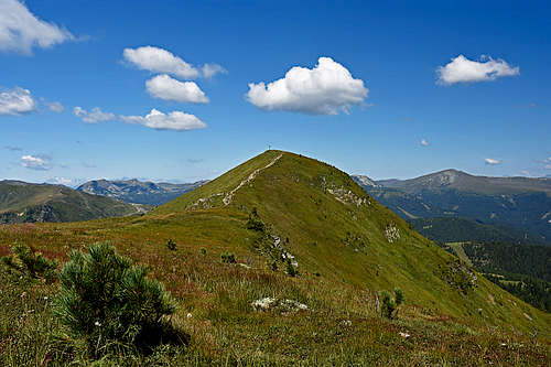
Gruft, 2232 m, and Schoberriegel, 2208 m, are two easily reachable summits in the high mountain ridge SE of the Turracher Höhe road pass. Being so close to the high and very frequented road pass many hikers quickly run up, especially on Schoberriegel, and some of them also continue by the panoramic, grassy ridge towards the SE. The most recommendable is round tour with trail head on the very road pass.
The name Gruft means Tomb in English and supposedly it comes from the feature on the very top. There is a big crack in rocks, a few metres deep, till summer filled with snow.
Overview
|
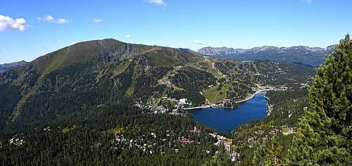
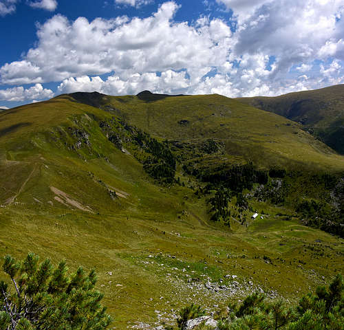
Just east of the road pass, 1795 m, and the biggest lake, also the ridge of Schoberriegel and Gruft begins. Both slopes are not too steep, on some places we can see picturesque rocks. Schoberriegel is already very panoramic, that's why many hikers simply turn back when reaching it. After it, the broad, gentle ridge continues towards the SE. It descends a bit less than 50 m and then rises again on the 24 m higher summit of Gruft. The NE side of this ridge is not steep, but descends quite deeply. The SW side is even less steep. Below the ridge there is a small plateau which was during the World War II designed as an airport - for whatever reasons (it was never put into operation). On the summit of Gruft towards the E-NE the main ridge of Nockgebirge continues - towards the nearby Kaser Höhe, 2318 m and further on. That one could of course be another easy hiking goal, but its visit requires to descend some 120 m (and later to gain that altitude again). But we are more interested in the ridge of Gruft itself, extending further towards the south. It lowers considerably, offering a nice hike, and over a few gentle elevations finally ends on the timber line with the bump of Schönebennock, 2002 m. East of the Gruft summit there is a valley-end with a high lying alpine pasture, called Nieder Kaser, 1967 m. Also on the W and SW there are lower lying huts, pastures and light woods with meadows. That area is more frequented, criss-crossed by many cart-roads. The broad saddle of Turracher Höhe is nice also due to many lakes and swamps. One of the trails is called Drei-Seen-Runde (The 3-Lakes-Round), visiting the biggest water surfaces. |
Getting There


The summits of Gruft and Schoberriegel can be ascended from the neighbouring valleys (Holzbodenbach, Saureggenbach, Hinterer Seebach), but far the most suitable trail head is the road pass of Turracher Höhe, 1795 m. There a good, asphalted road reaches from the south (from Patergassen, Carinthia) and from the north (Predlitz in the valley of Mur). On the road pass there are many parking places, some also free of charge, for example by the Panoramabahn (cable way).
Route
On the embedded map I am presenting you only some of the main paths, reaching the summit area. Due to not demanding terrain there are many more. And due to the touristically over-developed area of Turracher Höhe, there are also many tourist trails.
In the verbatim description I am presenting only the round tour from the Turracher Höhe. It can be done in any direction, but more recommendable is in the clockwise sense. In the lower part of return, there are some variants.

1. Turracher Höhe - Schoberriegel, T2, 1 h 15 min. It's a well marked, well beaten hiking path, bringing you on the first high summit. From the S side of the big lake we continue up, first in the E-NE direction. When reaching below the upper station of the Sonnenbahn (cable way), the ascent trail turns towards the SE. In many switchbacks we gain altitude, passing a few nice panoramic points. The ascent is easy, not even too steep.
2. Schoberriegel - Gruft, T2/T1, 15 min. The connecting ridge is clearly ahead of us, the path is very easy. The altitude loss is less than 50 m.
3. Gruft - Schönebennock, T2/T1, 30 min. In a gentle descent we cover some distance, the grassy ridge is very panoramic. Before reaching Schönebennock, the marked path already turns to the right - westwards,
4. Schönebennock - Obere Vastlhütte, T2, 30 min. On this a bit steeper descent we lose another 200 m of altitude. The descent goes first by grassy, later by forested slopes. Just above the pasture/hut we reach a cart road, 1827 m. There marks go to the right (northwards by a cart-road up, and further to the Schoberriegel via the ex air port) and also further down, towards the SW, to the hut. It's better to continue down!
5. Obere Vastlhütte - Turracher Höhe, T1, 1 h. From the pasture/hut we continue to the right, following the marked cart-road. A longer traverse brings us in the N-NW direction first to the Grünsee (lake), then soon to the main road and the road pass. Before the Grünsee we reach on 1775 m also the tourist trail called 3-Seen-Runde (The 3-Lakes-Round). It's not needed to follow it to the right. If you only want to return to the car, go left.
Non-marked return variant, T2, 1 h. When descending from the Schönebennock and you reach on 1827 m the cart road, you can continue your return also to the right. The cart-road ascends first a little, then it becomes non-marked (marks go to the right up) and finally ends on the last meadow. We gained up to 100 m of altitude, but we are returning more directly. Then the unmarked trail descends steeply to the left, finally reaching the Katscherhütte, 1790 m, and the 3-Seen-Runde (The 3-Lakes-Round). From there continue towards the NW to the road pass.
When to Ascend
Schoberriegel and Gruft can be ascended any time of a season. Basically it's more a summer tour, but due to quite gentle slopes also a ski tour must be very fine. In times of tour skiing the ridge is much less frequented, of course.
Turracher Höhe
This tourist resort is very popular and visited all the season. Around the road pass and the big lake there are many hotels, in winter many ski lifts and chair lifts are operating and in the woods by the lake there are hundreds of weekend huts. In hotels you can get accomodation any time of year.