
-
 32667 Hits
-
 90.07% Score
-
 31 Votes
|
|
Mountain/Rock |
|---|---|
|
|
45.65100°N / 122.005°W |
|
|
2445 ft / 745 m |
|
|
Overview
Hamilton Mountain is one of the best climbs/hikes in the Columbia Gorge and for good reason. The views are great with Mt. Hood and Mt. Adams visible in the distance and most other Gorge peaks visible, such as Mt. Defiance, Tanner Butte, Chinidere Mt., Wind Mt., Yeon Mt., (not yet put up on SP, but worthy) and Larch Mt. to mention a few. The trailhead starts out at Beacon Rock, (an excellent warm-up for hikers and a wonderful rock climb for the experienced and capable) then passes through a small area of surprisingly primitive low elevation old-growth forest in Beacon Rock State Park (especially if you take the trail option around the west side of Little Beacon Rock), past three great waterfalls, and then a challenging switchback climb of over 2,000 vertical feet to the windy, exposed summit.
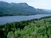
South face of Hamilton Mountain from the Oregon side of the Columbia River
In addition to the above, along the way you will have great views of precipitous cliffs, an opportunity to take a catwalk trail along the top of the lower cliff formation, a view of a few seasonal waterfalls, and the spectacular view up and down the always inspiring Columbia River Gorge. There is also a newly constructed short spur trail to the top of Little Beacon Rock that offers great views of its big brother to the south.
I've yet to see a rock climber on any of the impressive cliffs on the mountain, possibly because Beacon Rock is easier to get to and even more challenging. Another possibility is the crumbly nature of the rock on the cliff face that looks a little dangerous. The lower cliff faces are about 350 feet high and the upper cliffs are over 1,100 feet high so they would be a challenge indeed!
The trails are all well marked and for the most part, in excellent shape throughout the area. See the map for a complete rundown of all the trails with distances. The basic loop totals 8.44 miles from the rest area or 7.60 miles from the upper parking area. Total elevation gain round trip, due to a few ups and downs in the trail from the upper lot is ~2,450 vertical feet and ~2,615 feet from the lower lot. (I'll get this honed in to a more precise number soon, but that's pretty close.)
A note on the summit elevation: The USGS list Hamilton's summit at 2,438' but lists 2,445' on their website. A sign at the summit gives it as 2,488' and my GPS read 2,435 on a recent trip. I'll use the USGS website figure for now but would be curious to hear what GPS readings other climbers get.
 |  |  |  |  |
A few of the views of the area
 |  |  |  |  |
Getting There
Take Washington State Hwy 14 east of Vancouver, Washington. Park at MP 35 at the Beacon Rock Rest Area at Beacon Rock State Park. In the summer and in good weather year around you can drive up the short access road to the park picnic and camping area on the north side of the highway and save about .8 miles round trip on the hike. The rest of the time, the gate on the access road is closed but it's only a short extra distance to walk. Note: In the winter, or when the regular camping area is closed, the gate is closed and locked after sundown so don't get locked in - it's posted, so take note of the instructions.)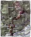 | 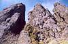 |  |  |  |