
-
 810 Hits
-
 78.15% Score
-
 9 Votes
|
|
Mountain/Rock |
|---|---|
|
|
38.09298°N / 105.65529°W |
|
|
Custer County |
|
|
Hiking, Mountaineering, Skiing |
|
|
Spring, Summer, Fall, Winter |
|
|
13311 ft / 4057 m |
|
|
Overview
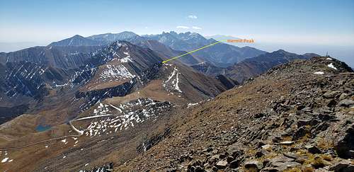
Hermit Peak A
Elevation: 13350 ft / 4070 m
Colorado Rank: 353
Colorado 13er Rank: 300 of 584
Range: Sangre de Cristo Mountains, Colorado
Nearby 13ers:
|
|
Getting There
|
|
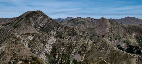
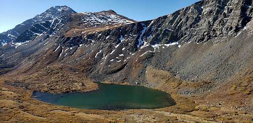
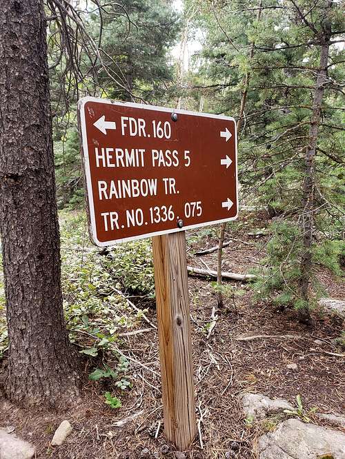
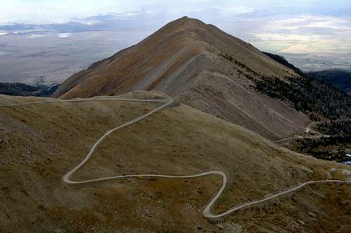
From the Town of Westcliffe and the intersection of Highways 69 and 96, drive south on 69 a few blocks (about .3 mile) and turn west onto Hermit Road (CR160). Drive 6 miles to an intersection where you should stay left. From this point, it's about 9 miles to the summit of Hermit Pass if you can make it. The road quickly becomes a rough 2WD for the next 1.25 miles and then degrades even more to 4WD, high clearance advisable, if not required. The higher you go on this road, the rockier it becomes with a section or two near and above tree line that crosses through talus slopes of rubble. For our suggested climb of Spread Eagle and Peak of the Clouds, park at the coordinates provided which will be a wider spot in the road at about 11,970 ft. elevation and directly below a saddle to the north that lies between Pt. 12818 and Pt. 12,671. There will be a few remaining trees here. Additional parking can be found just a little farther at the tight turn at 12,060 overlooking Horseshoe Lake.
|
|
Route

|
|
This is fun, driving this road will leave mark on your soul. Hermit Road requires 4WD, slow driving and good clearance. Doesn’t matter what kind of vehicle you have or drive your speed won’t be faster than 5 mph. There are several large pull-offs and camp spots along the road, including an excellent spot on the left, near 10,960'. It’s up to you, your driving skills, your comfort zone on very rocky road and most importantly on what kind of vehicle you drive to determine how far you can drive. My advice in this case is to park somewhere bellow Hermit Lake trailhead and continue walking on the road. I did this road twice, but I had more fun walking this road than driving it to the top of the pass.
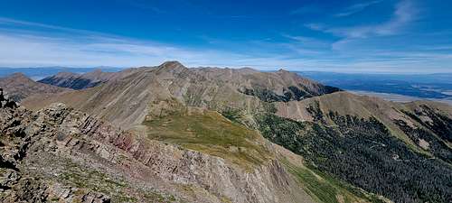
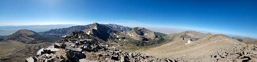
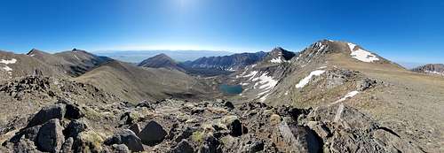
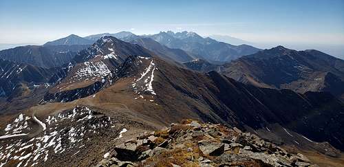
From your parking spot, start walking up the road. Pass the trail to Hermit Lake (left) near 11,400' and exit the trees near 11,900'. Switchbacks continues north up to very slope to reach an overlook with beautiful views of Horseshoe Lake and Eureka Mountain. Continue on the road for another mile to reach Hermit Pass, at 13,000' . From top of the Hermit Pass you can see the summit which is about mile away up to gentle slope. You have two possible ways or directions to the summit, one is straight up, which leads to the summit. Second option is go to the right toward ridgeline, once on the ridge getting to the summit is more than obvious.
|
|
Red Tape
Sangre de Cristo Wilderness was designated by congress in 1993 and it now has a total of 220,803 acres. All of this wilderness is located in Colorado and is managed by the Forest Service and the National Park Service. The Sangre de Cristo Wilderness is bordered by the Great Sand Dunes Wilderness to the west.
Sangre de Cristo is Spanish for "Blood of Christ," but no one is quite sure why the region was given this name. Was it because of the bloody hues washing the slopes at sunset, or the cry of the dying priest, "sangre de Cristo," as his martyred blood flowed onto the ground near here? Of the long and colorful Spanish influence in these mountains and in the San Luis Valley below there is no doubt. Two four-wheel-drive roads over Medano Pass and Hayden Pass, as well as access to Lily Lake, were slim exclusions from Wilderness designation and split the area into four distinct sections.
Unlike most of Colorado's mountains, the high and magnificently rugged Sangres were uplifted suddenly in massive blocks, creating a range of dramatic vertical proportions. Four fourteeners are clumped together in the midsection of the Wilderness, including Crestone Needle (14,197 feet). Many climbers, consider the Needle to be Colorado's most challenging 14,000-foot peak. Three more fourteeners stand together just south of the boundary. Melting snow feeds many creeks and small lakes, and nourishes a forest of oak, aspen, and spruce. Black bears and a few mountain lions live here, along with elk, deer, and bighorn sheep.
Long (about 70 miles) and narrow describes the area, the state's third largest, and the going is rough for the hiker. Most of the 180 miles of trails end at alpine lakes set against virtually unclimbable walls. Great Sand Dunes National Preserve in now part of the Sangre de Cristo Wilderness.
Please help keep Wilderness wild by following Leave No Trace practices.
At a Glance
|
Restrictions: |
|
|
Closest Towns: |
Pueblo, Colorado; Westcliffe, Colorado; Salida, Colorado; Cotopaxi, Colorado |
|
Water: |
Treat all non-potable water before consuming. |
|
Operated By: |
Forest Service; Park Service |
|
Information Center: |
|
General Information
Topo maps
Forest Service Topography Maps: These maps overlay Forest Service assets, such as roads, trails, and campgrounds, on USGS's topographic maps. They are available for download by quadrangle.
Buy maps online
National Forest Store: Offers a full, nationwide selection of National Forest, Ranger District, Wilderness, and Specialty Maps for purchase online or by phone, fax, and mail.
Colorado’s Fourteeners
Find more information about climbing Colorado’s peaks at the Rocky Mountain Region 14ers page.
Wilderness.net
Go to Wilderness.net for additional maps and information about Wilderness.
When to Climb
Add When to Climb text here.
Camping
- Camp sites must be at least 100 feet from trails, lakes, streams, and any water source. Please use an existing site. Before leaving, 'naturalize' your campsite by removing signs of your use.
- Obey posted signs prohibiting camping or other activities. Some campsites may be closed to allow the area to recover from overuse.
Trails
- Cutting switchbacks in trails is prohibited. Shortcuts cause severe erosion, eventually destroying the trail.
External Links
https://www.14ers.com/peaks/10658/hermit-peak-a
https://peakvisor.com/peak/hermit-peak-15tyijjns.html?yaw=-46.86&pitch=-0.28&hfov=44.42
Hermit Peak | 13,311' › Hermit Peak North Ridge Route& Map / Colorado 13ers (climb13ers.com)
Hermit Pass – Westcliffe, CO | County Road 160 – 4WD High-Clearance (uncovercolorado.com)
Hermit Peak A - Climbing Routes, Photos & Maps | 14ers.com
Hermit Pass OHV Trail: 107 Reviews, Map - Colorado | AllTrails
https://listsofjohn.com/peak/437
https://www.14ers.com/route.php?route=201401170732113