
|
|
Mountain/Rock |
|---|---|
|
|
38.02450°N / 105.6008°W |
|
|
Custer & Saguache |
|
|
13554 ft / 4131 m |
|
|
Fluted Peak Overview
 Fluted Peak
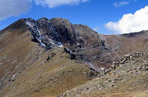
Fluted Peak lies at the head of the Dry Creek drainage in the heart of the central Sangre de Cristo Mountains. It stands as one of the most dramatic peaks north of the Crestones, and when its rugged northeast face is holding snow, the reason behind its name becomes clear. The peak has easy hiking routes up its east and north ridges. Once you've earned the summit of Colorado's 215th tallest peak, you're rewarded with fantastic views of the Crestone Peaks, Kit Carson Mountain, Mount Adams, and one of the largest lakes in the Sangres, North Crestone Lake. If you're up for a longer, multi-summit day, neighboring Little Horn Peak and Horn Peak can be added to your journey by hiking the connecting ridges. If you include Horn Peak, you can make your trip a loop hike by descending either the Horn Peak Trail or the Dry Creek Trail.
Little Horn Peak (13,143') Overview
 Little Horn Peak
Little Horn Peak is at the end of Fluted Peak's east ridge. When you've expended so much energy to summit Fluted Peak, this modest summit is a sensible addition to your itinerary. Little Horn is most easily climbed from its saddle with Fluted Peak.
Little Horn is Colorado's 530rd tallest peak, and from certain places in the Wet Mountain Valley, it does indeed look like a smaller version of Horn Peak. When seen from the south or southwest, however, its countenance can blend with Horn's, making it difficult to see sometimes.
Getting There
Most people will approach Fluted Peak from east of the range crest, using either Horn or Dry Creek, however an approach from the west using one of the Sangres' longest drainages, North Crestone Creek, is also possible.Both the Horn Lakes and Dry Creek Trails are accessed by starting at the Horn Creek Trailhead near Horn Creek Ranch. To get to the trailhead, drive south from Westcliffe on SH-69 and turn right on Schoolfield Road after ~3 miles. Go a mile west on Schoolfield and then turn left on Macey Lane and head south for 2 miles. Turn right on Horn Road and head west to Horn Creek Ranch, which is reached after ~3.5 miles. At the ranch, turn right at a signed junction and reach the Horn Creek TH after .25 miles. Some of the drive to the TH is paved, and the dirt roads are in great condition.
The North Crestone Creek, the western alternative, starts about a mile north of the town of Crestone. The trail approach to North Crestone Lake is about 6.5 miles, and a climb of Fluted would be around 3 miles round-trip from the lake.
Red Tape
Fluted Peak is located within the Sangre de Cristo Wilderness. Typical wilderness restrictions apply. Contacting the managing agencies (see 'Mountain Conditions') is the surest way to get up-to-date information.Leave No Trace suggests you observe these principles when traveling and camping in all public lands, especially wilderness:
1. Plan Ahead and Prepare
2. Travel and Camp on Durable Surfaces
3. Dispose of Waste Properly
4. Leave What You Find
5. Minimize Campfire Impacts
6. Respect Wildlife
7. Be Considerate of Other Visitors
When To Climb
The easiest time to climb Fluted Peak is June-October, but this varies year-to-year with the snowpack. In spring or winter conditions, the standard routes cross potential avalanche terrain, so awareness is imperative.Camping
Camping is permitted in the Sangre de Cristo Wilderness. Good camp spots are available in Dry Creek, Horn Creek, and North Crestone Creek.Mountain Conditions
The US Forest Service is your best bet for determining current snow conditions and gathering other such information. The San Carlos Ranger District (719-269-8500) of San Isabel National Forest is responsible for the Sangres east of the range crest. Another good contact number for the east side is the Westcliffe Ranger Station (719-783-2079). The Saguache Ranger District (719-655-2547) of Rio Grande National Forest is responsible for the Sangres west of the range crest.For weather information, the National Weather Service is a good place to start:
Fluted Peak experimental point forecast