
-
 51447 Hits
-
 89% Score
-
 28 Votes
|
|
Mountain/Rock |
|---|---|
|
|
38.00750°N / 105.6042°W |
|
|
Saguache |
|
|
13941 ft / 4249 m |
|
|
Overview
Located in Colorado's Sangre de Cristo Range, near the 14,000 foot peaks of Kit Carson, Challenger, Crestone and Humboldt, this peak can be climbed from either the Crestone side of the Sangres or the Westcliffe side.
From the Crestone side, down in the flats (on the road below the trailhead), the peak looks rather "small" and pyrimidal and in the background. The lower summit of the peak appears larger in the foreground.
This makes for a great climb in and of itself. The views it offers of the peaks to the West and South: of Challenger, Kit Carson, Crestone and Crestone Needle are awesome.
Adams may be under 14,000 feet, but it earns all of the respect of the big peaks and the difference is less than 70 feet. Adams is one of the highest 100 peaks in Colorado..
 |
 |
 |
 |
 |
 |
 |
 |
Getting There
To the trailhead on the Crestone / San Luis Valley Side: Take highway 17 to County Road T to Crestone. Once in "downtown crestone," turn right at the intersection shown in this photo and uphill to the trailhead for South Crestone Lake and Willow Lake (trailhead parking is at the same location for both trails).
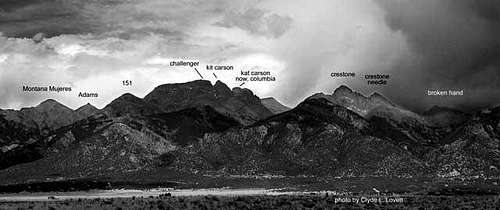
the Sangre de Cristo Range in Crestone area from the San Luis Valley |
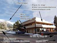
The corner, downtown |
Route Information
Please read West Ridge (from Willow or South Crestone Lakes)
or
Northeast Ridge Route (less common)
Either of the trails - South Crestone Lake Trail or Willow Lake Trail will get you to Adams summit. The trail which may be the easiest to follow visually would be the Willow Lake Trail. Willow Lake trail is very heavily travelled and very well marked.
Willow Lake Route:. Follow trail to Willow Lake. Just as you arrive at Willow Lake there is a campsite on the North of the lake. From this campsite go north and up the steep grassy slope towards the saddle between Adams and "Lower Adams." You will not see the saddle as you begin, but after you reach the top of the grassy slope mentioned here it will come into view. After hiking above the headwall in the photo shown (Photo 1 below), the saddle comes into view
This saddle is best approached from the north east part of the drainage instead of the south west part, although it may look to be a bit longer. The saddle is conspicuous with a lot of loose rock beneath it. There are usually good path to either side of the loose rock. (Photo 2 below)
Once you make the saddle, turn right (to the east) towards the summit. Lean to the West to follow the trail. Photo 3
From the same saddle you could head to the west and hit the summit of Montana Mujeres, the lower peak. This summit is by far more gentle and also offers fantastic views.
Additionally, there is a route to this saddle from South Crestone Lake. From South Crestone Lake the saddle is in view to the South - South West. As you approach the saddle from the lake, stay to the East for the easiest hiking.

Photo 1 view of summit along hike |
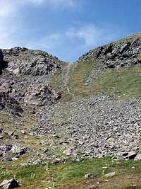
Photo 2 Saddle between Lower Adams & Adams Summit - approaching from Willow Lake |
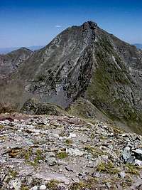
Photo 3 - ridge to Adams |
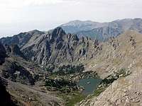
South Crestone Lake from Lower Adams |
Camping
Willow Lake and South Crestone offer camping. Camping is not permitted within 300 feet of the lake, but there are plenty of idyllic spots which satisfy that criteria.
This saddle between Adams and Lower Adams (also called Montana Mujeres) connects the South Crestone and Willow creek drainages. One could camp at South Crestone, swing by Adams and then continue on to camp at Willow Lake and be within striking distance of Challenger and Kit Carson.
Red Tape
Adams is near the boundary of the Rio Grande National Forest and the San Isabel National Forest. It is also located in the Sange de Cristo Wilderness - Colorado's 3rd largest wilderness. More information with more links can be obtained here:
More info at: http://www.coloradowilderness.com/wildpages/sangre.html
UPDATED INFO:
From the Saguache County Board of County Commissioners: On Friday, April 20, 2007 it was agreed that the County, Forest Service, Park Service, NAT, spiritual centers and Manitou Institute will collaborate to post signage to discourage hikers from trespassing through private property to access Forest Service land East of the Baca.
Thus as of 4/20/2007, posted Forest Service trailheads make for the only legal access.
Even representatives of the CO Mountain Club are going to help get the trespass access points removed from climber websites they have connections with. **********************
Sangre de Cristo Range
Colony Baldy Rito Alto Peak Horn Peak Mt. Adams Crestone Peak Crestone Needle Kit Carson Peak Humbolt Peak Tijeras Peak.
External Links
- Colorado Climbers Links, photos, partners, 14ers, 13ers, ice climbing, rock climbing, mountaineering, messages, chat room ect.
- Montaña Mujeres (UN 13,546), Mount Adams & Pico Guante (UN 13,153)
- Team Arp Climbs Mt. Adams Sept. 2003
bradhepp - Dec 9, 2005 2:47 am - Hasn't voted
Untitled CommentA terrific Sangres panorama with labels and elevations can be seen at http://www.sangrespanorama.com, a site I created for the photographer, Richard Carson. Several of his Sangres shots can be viewed on his gallery site, http://www.richardcarsongallery.com
We'd love your comments.