
-
 33991 Hits
-
 87.24% Score
-
 24 Votes
|
|
Mountain/Rock |
|---|---|
|
|
37.61400°N / 105.498°W |
|
|
13849 ft / 4221 m |
|
|
Overview
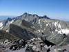
California Peak is the 84th highest peak in Colorado. While many native Coloradoans will cringe at having one of their beloved centennials named after a rival state, it may be an apropos name for it could easily serve as a perfect introduction to the Colorado Rockies for beginner hikers from California. California Peak, like its centennial neighbor Huerfano Peak (Point 13,828) is a neglected stepsister of nearby 14ers Mount Lindsey, Blanca Peak, and Ellingwood Point.
When you eventually enter the upper Huerfano River Valley (What?? You haven’t been there yet!!!) your eyes will immediately be drawn to the incredible 14ers, but pity those who ignore this gentle giant, for on its rounded slopes are hidden incredible scenery and solitude, and one of the best beginner mountain hikes in the state (That’s really not an overstatement).
 |  |  |  |
Getting There
California Peak can be reached from either the Upper or Lower Huerfano Trailheads. The “normal” and easier route starts from the Lower Huerfano Trailhead. To get there, take Interstate 25 to Walsenburg, Colorado (exit 52). Shortly after exiting the highway turn west onto Colorado 69 (ha ha, am I the only immature one here?) and go 25.1 miles to Gardner. Continue through town and turn west towards Red Wing. Measuring from this junction, go straight at mile 5.1. Soon afterwards the road becomes a very passable dirt road. At 12 miles take the left fork and pass the Singing River Ranch at 16 miles. This is as far as the road is plowed in winter. Past this point, the road is on private property till the trailhead (aka no camping). The road gets significantly rougher after the Ranch. I took my parents minivan up here (please don’t tell them) and while bumpy, it wasn’t horrible. High clearance would certainly be easier on your nerves. The Lower Trailhead is at 21.2 miles. The Upper Huerfano Trailhead is another mile or so further up the road and necessitates a 4WD vehicle with high clearance.
Red Tape
No permits, parking passes, or fees. This is public land at its best. Remember though that you have to drive through a large stretch of private property to get to the trailhead. Wait till you’re on National Forest land before you park or camp.
When To Climb
While summer is of course the normal season, California Peak actually might be a nice (and long) winter climb. Of course, be aware of the steep slopes and avalanche potential in the area.
Camping
This is an “undeveloped” area yet due to its popularity, there are a number of spots for camping, especially near the Upper Huerfano Trailhead. Another extremely pleasant option is to pack into the basin and set up camp in the basin. Rumor is that this is a popular hangout for our ursine brethren so bring your bear bag and keep an ear open for the fuzzy beasts (singing loudly might help too!)
Mountain Conditions
Always check avalanche conditions before heading into the Colorado High Country!!
Avalacnhe Conditions
External Links
- Same day, same peaks... in reverse!
- California Dreaming… 7.5meg video from California Peak filmed June 4, 2005