
-
 13758 Hits
-
 84.82% Score
-
 19 Votes
|
|
Mountain/Rock |
|---|---|
|
|
36.57063°N / 117.81305°W |
|
|
Inyo |
|
|
Hiking, Scrambling |
|
|
Spring, Summer, Fall |
|
|
9690 ft / 2954 m |
|
|
Overview
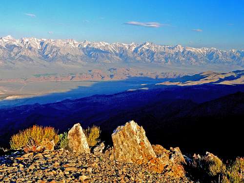 High Sierra at sunrise from Inyo crest
 Fortunately for peak baggers the road which climbs almost 5,000' from the Owens Lake to Cerro Gordo makes this moderate day hike a pleasurable jaunt along the top on the range with outstanding views on all sides.
To the west, above Owens Valley is the monumental eastern scarp of the High Sierra stretching the length of the horizon. To the north the higher Inyo peaks stand out along the spine of the range. The eastern view takes in Saline Valley and the northern ranges of Death Valley National Park. To the southeast the Panamint Range is topped by Telescope Peak and southwest lies the vast expanse of the Owens Lake area with massive Olancha Peak dominant on the edge of the Southern Sierra.
Getting There
 Saline Valley, Last Chance and Cottonwood Mtns., east from Inyo crest
Park at the saddle and walk north up the road that goes to the left around the western side of the crest 1.5 to another saddle where the road continues winding south up to radio facilities. Leave the road here and hike north along the crest .75 miles to the south summit, drop down a bit on a rugged use trail and traverse along the west side of the south summit .4 miles and up to the main summit. Judging from the register some people have been fooled by the south peak since the main summit is hidden from view at that point, me included the first time I hiked it.
Red Tape
 Cerro Gordo Road
Camping
 Owens Lake and Olancha Peak from Inyo crest
The nearest campgrounds I could find were Tuttle Creek Campground and the Lone Pine Campground in the Alabama Hills west of Lone Pine.
Tuttle Creek Campground: From Hwy. 395 in Lone Pine go west on the Whitney Portal Road 3.2 miles.Turn south and go 1.7 south on Horseshoe Meadows Road. Turn right (west) and go .9 miles to the Tuttle Creek Campground area.
Lone Pine Campground: Go 6.5 miles west on the Whitney Portal road from 395 in Lone Pine. Take a short left .35 miles then a right .5 miles to the campground.
Current weather conditions
 Sierra crest pano from Pleasant Point
 Saline Valley from Pleasant Point
Bob Burd - Dec 11, 2009 2:21 pm - Hasn't voted
Pleasant PointThis peak has been called "Pleasant Point" by the DPS for many years, and is probably a more appropriate title for the summit.
Noondueler - Dec 11, 2009 2:37 pm - Hasn't voted
Re: Pleasant PointAndy Zdon calls it Pleasant Mtn. and I've seen that a few other places but it's not named on the topo so I'll go with Pleasant Point. Thanks Bob.
Bob Burd - Dec 13, 2009 3:54 pm - Hasn't voted
Re: Pleasant PointSorry, I hadn't seen that Zdon had it named differently. Guess you can go with either! :-)
Noondueler - Dec 13, 2009 4:18 pm - Hasn't voted
Re: Pleasant PointI had already put (alias Pleasant Mtn). at the beginning of the overview so I decided to add (Mountain} next to Point. That should cover it.
gimpilator - Mar 30, 2015 2:13 pm - Hasn't voted
Red Tape updateI hiked up there a couple days ago. The locked gate above town, which is describe in the Zdon book, is now posted with No Trespassing / Private Property signs. There are also sidebars on either side of the gate to deter foot traffic. We did hike the road despite these signs. I think it's on a permission sort of basis. We spoke to the caretaker who lives at the ghost town and told him we were planning on doing Pleasant and Cerro Gordo. He has us sign a "waiver" which was just a notepad log book. He did not give us permission to walk the road toward Pleasant nor did he discourage us from doing so. For those planning a trip, it might be best to check in with him before proceeding.
T. White - Jan 18, 2018 5:40 pm - Hasn't voted
Re: Red Tape updateThanks for the heads-up. The new Cerro Gordo mine website now says the following: "All visitors must check in with our caretaker, sign a liability waiver and pay for admission before exploring the town." (http://cerrogordomines.com/) Edit: I did the hike with permission from the caretaker-on-duty, and parked at the saddle above town. No problems.