
|
|
Mountain/Rock |
|---|---|
|
|
40.67097°N / 121.67367°W |
|
|
Shasta |
|
|
Hiking, Scrambling |
|
|
Spring, Summer, Fall |
|
|
6681 ft / 2036 m |
|
|
Overview
Jacks Backbone is a volcanic peak in the Cascade Range. It is located in Lassen National Forest, just west of Thousand Lakes Wilderness and north of Latour State Forest. The rocky summit offers great views of Crater Peak, Lassen Peak, and the Bunchgrass Valley. Jacks Backbone viewed from the south
Cross-country travel is required to access the summit, although a number of forest roads surround the mountain and offer a variety of scrambling route options. This area has a lot of brush, so it's worth your time to scout out a good line and also to wear some sturdy pants. The peak has approximately 800 feet of prominence.
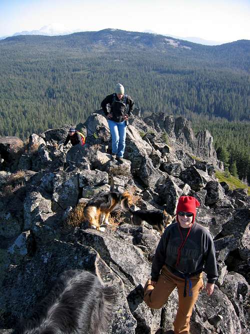 scrambling up to the summit with Lassen Peak in the background
 boulder atop Jacks Backbone summit ridge and Lassen Peak in the distance
The Name
According to California Place Names (Gudde & Bright), the mountain was named when J.M. Simmons' hired man, Jack, was washing his clothes in a nearby stream (probably Cow Creek). Simmons noted "when you're humped over like that, you look like yonder mountain". east side of Jacks Backbone
 crags and wildflowers found on the Backbone Lake Trail
Backbone Lake Trail
There is also a hiking trail located on the northeast side of the mountain. Forest Service Trail 3E02 follows an old road alignment northwest for 3/4 mile, climbing 370 feet in elevation and ending at Backbone Lake. This clean, shallow pond is very scenic with a great view of the west side of Crater Peak. There is no sign or trailhead, so bring a map and look for the clearing where the trail starts.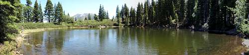 Backbone Lake
 Crater Peak viewed from the Backbone Lake Trail
 topo map with Backbone Lake Trail
Getting There
Jacks Backbone is accessed by Forest Service Road 16, which begins at State Highway 44/89 at the Ashpan Snowmobile Park. Follow this road northwest for approximately 10 miles to access the east side of the mountain and the Backbone Lake Trail.While winter and spring automobile access is usually limited due to snow, the convenient snowmobile park makes a snowmobile approach to the area a feasible option.
Alternate access to the southwest side of the peak is available through Latour State Forest. Forest Road 32N47A, located on State land, probably provides the highest starting point for a scramble of the peak. This road begins near Cow Creek and ends at an old log landing near the National Forest boundary.
 Lassen National Forest visitor map of vicinity
Red Tape
None for hiking.California Campfire Permits are required for use of stoves, lanterns, and campfires outside of developed recreation sites.
Motor vehicles are restricted to designated roads, trails, and areas on Lassen National Forest. Motor vehicle use maps are available at any Lassen NF office free of charge.
Camping
Two nice campsites are located at the southern base of the mountain on Cow Creek just off Forest Road 32N47. These sites are located in, and managed by, Latour State Forest. A vault toilet is available near the campsites.External Links
An interactive map of the area is available on Caltopo here:topo map