
|
|
Mountain/Rock |
|---|---|
|
|
37.63898°N / 107.5946°W |
|
|
Scrambling |
|
|
Summer |
|
|
13265 ft / 4043 m |
|
|
Overview
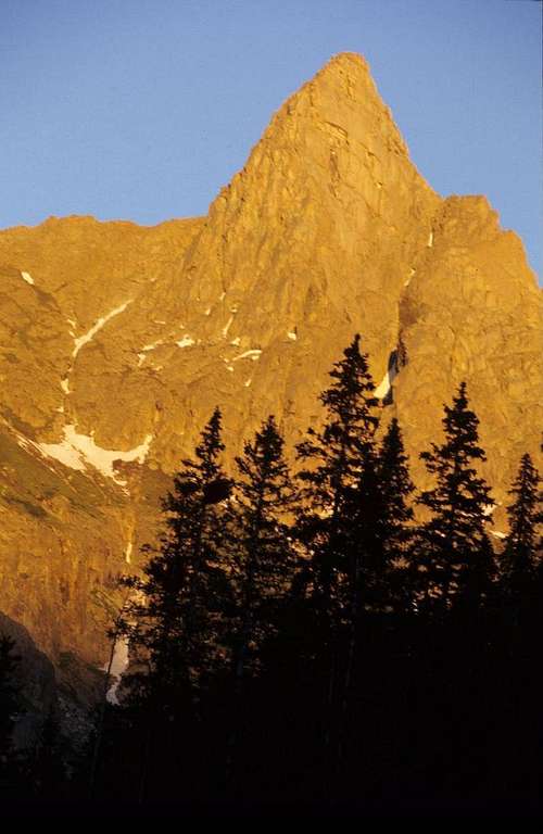
Knife Point is one of the most remote peaks in Colorado, located north of Sunlight Peak, deep in the heart of the Weminuche Wilderness. Most people venturing into this area come to climb Jagged Mountain, one of Colorado’s 100 highest mountains, but it is Knife Point, with its prominent position as one heads up the Noname Creek valley, its magnificent West Face, and beautiful spire-like lines that seems to draw your eyes to it whenever you are nearby.Getting There
It is also possible to reach this same point by hiking 9 miles from the Durango Ski Area on highway 550 between Durango and Silverton. The trailhead is located twenty six miles north of Durango, and twenty four miles south of Silverton. There is a large parking area on the East side of the road. From the parking lot, descend down past the register,then proceed along a winding trail that descends the Purgatory Creek drainage for about 1.5 miles to Purgatory Flats. From here, the trail turns right through sometimes thick grasses, and follows Cascade Creek for about three senic miles to the Animas River. Cross the river on a nice bridge, then proceed over the traintracks then north on a nice trail along the East bank of the Animas River. From here it is five miles to the Needleton Bridge. The standard approach does not head up to Chicago Basin. There are nice campsites the whole way along the river here.
Once reaching the East Side of the Needleton Bridge, continue north along the east side of the river on a well defined trail for about a mile. The Ruby Lake trail branches off at a large field, and the path along the river becomes much fainter. Continue along the river past a few stream crossings until reaching "Watertank Hill". There are several possibilities at this point, some of which are reputed to have fixed ropes on them. When the water is low, it is possible to stay near the edge of the river. When we went there in June, it seemed best to take the highest alternative over the crest of the hill, which was straightforward but included some very steep trail!
Once back at the river's edge, proceed for about a mile on a faint trail to the chilly waters of Noname Creek. Cross this, then find a good trail along the north side of the creek that heads up into the Noname Drainage. I didn't initially see the trail, but after working my way several hundred yards up the creek, and angling back and forth a bit, the trail came into view. This valley is one of Colorado's magical places, first climbing steeply through thick forest, then later on much more level terrain. About two miles up the valley, when the angle eases, and the spectacular cliffs of Animas Mountain loom on the right, Knife Point appears distant and majestic at the head of the valley. Four miles from the river at 10,750 feet, where a part of the valley wraps around Peak Thirteen, there is a split in the trail. Take the left fork and climb steeply for a few hundred yards to a wonderful campsite beneath Knife Point and Peak Ten at about 11,000 feet elevation.
 View from the summit of Knife Point.
There are a few other longer approaches that could be used, all of which involve off trail travel. It is possible to reach this same campsite, either climbing the difficult trail up and past Ruby Lake to the 12,700 foot pass between Monitor Peak and Peak Twelve. From here, descend (largely off trail) to the trail junction mentioned above. A second alternative is to climb up to Chicago Basin. From here, climb the slope between Glacier Point and the Twin Thumbs to a 13,000 foot pass. From here descend down snow (ice axe and crampons) past a beautiful lake eventually reaching the same point. These approaches will most often be used when climbing other peaks in the area as well.
It would also be possible to approach the peak starting from the Vallecito Creek drainage, but this would require fording Vallecito Creek.

Red Tape
This is a federal wilderness area. There are no motorized vehicles allowed, and when it has been dry, there are sometimes restrictions on open fires.The National Forest Service recommends packing out toilet paper, and it is always a good idea to hang all of your food. I had a marmot eat the bottom of my sleeping bag while I've been filling my waterbottle only a few miles from here.
Camping
The traditional campsite for Knife point is in the valley beneath the sharp cliffs of Peak Ten and Knife Point. There is also a dramatic view of the huge face on the East side of Monitor Peak here.History
An ascent of the dramatic NorthWest Spur of the peak was described in the May, 1978 issue of Trail and Timberline. The climbers rated the route 5.7 A2 but it may go free at the 5.9 or 5.10 level.Most ascents climb to the saddle north of the summit between Knife Point and Peak Ten, then around onto the east side of the peak up sand covered rock. I will provide a more detailed description of this route within a few days.
External Links
Two excellent books with information concerning knife point are:Rosebrough, R., Climbing Colorado's San Juan Mountains, Falcon Publishing Co., 1999
Garratt, M. and B. Martin, Colorado's High Thirteeners, Cordillera Press, Inc. 1989 (there might be a more recent edition as well)
Both of these were used for information on this web site.
There is a beautiful picture of Sunlight Peak and Spire taken from Knife Point here.
National Forest Service Information for the area can be obtained at this web site.
[img:357491:aligncenter:medium:]
Seasons to Climb
Most people climb Knife Point during the summer season. The weather in June and early July is usually quite nice with thunderstorms being much more isolated than later in the summer. Particularly early in June, expect the possibility for deep snow in places, as well as the occasional snowstorm. The Needle Mountains seem to be a focal point for thunderstorms, so late July and August can get scary once the "monsoon" gets ramped up. At this time of year, expect the lighning to begin as early as 10:00 AM. September and October can bring wonderful clear weather, but realize that you are way, way back from roads or help if a sudden blizzard buries the range with a few feet of snow.Ascents within the Needle Mountains are occasionally made in the winter. However, such an undertaking is not for the faint of heart as the approach and climb both cross many avalanche paths. Local Weather Forecast