
-
 34219 Hits
-
 90.81% Score
-
 33 Votes
|
|
Mountain/Rock |
|---|---|
|
|
37.86420°N / 107.4656°W |
|
|
13841 ft / 4219 m |
|
|
Half Peak Overview
 Half Peak in October. Photograph coutesy of chicagotransplant.
Half Peak is a striking mountain comprised of a high summit plateau guarded by dramatic cliffs. The unique shape of this mountain once earned it the name "Three-Corner Table". It has also born the names "Winner Tower", "Escarpment Peak", and "Wild Boy Peak". The appropriate designation Half Peak is now its official name. The constrained summit strikes one as a vision of something mystical, a 13,841 foot Devils Tower of sorts. Viewed from one of the three fourteeners just to the north (Handies Peak, Sunshine Peak, or Redcloud Peak), Half Peak is an intriguing sight, presenting its fearsome north face for inspection. It gives the appearance of a summit beheaded. Cliffs guard the summit on almost all sides. This peculiar formation makes for a rewarding climb.
The normal (South Ridge Route) route follows the one weakness in Half Peak's defenses for a memorable summit ride. This narrowing ridge is not difficult as it it follows a route pointed out by the continental divide (literally if you will look at the topo map)... It lacks a well defined trail but the ridge is easy to follow. And once it pinches to a narrow walkway, just below the summit, the route finding is fun, and the exposure makes it quite exhilarating. It reminds me of a narrow catwalk to the castle proper. It is one of the more gothic summits I have visited.
Half Peak harbors one of the San Juans most difficult north faces rising 800 sheer feet above an immense rock glacier at the head of Square Gulch. This face has seen been climbed; Jeff Lowe and Larry Derby accomplished this in 1972. The nature of the San Juan rock makes this even more impressive of an accomplishment.
The mountain is located between the upper Lake Fork of the Gunnison River and the Rio Grande River. The easiest route crosses the Continental Divide four times. The terrain is generally rolling grassy tundra broken by occasional cliff bands and isolated summits. This is a wild, unprotected area of the San Juans that beckons climbers and explorers. The possibilities for extended trips and climbs in this sprawling wilderness are endless. The lack of wilderness protection highlights the short commings of congressional designation. This IS wild terrain.
 Half Peak from Square Gulch. Photo courtesy of John Kirk
Getting There
 Hourglass Ridge on Half Peak.
Drive two miles south of Lake City on Colorado 149. Take the right fork, the paved Lake Fork Road, toward Lake San Cristobal. Beyond the lake, follow the good unpaved road along Lake Fork Gunnison River. At a junction a mile and a half beyond Mill Creek Campground, take the left fork. Drive a little over a mile farther, passing through the ghost town of Sherman at 13 miles. A trail head area is on the left.
The trip involves a short backpack trip to Cataract Lake, where the climb begins. An excellent trail winds south up Cataract Gulch. Above timber, the trail climbs the east side of the drainage. It crosses back to the west side to complete the 4.2 mile backpack route to Cataract Lake. According to the route profiling feature in the National Geographic Topo! software, it is 5.5 miles to the saddle on Half Peak's NE ridge, and 6 miles to Half Peak's summit.
See the Cataract Route description for more details (upper left).
 Half Peak from Cataract Gulch.
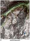
Maps
Expect great expanses of tundra above timberline and typically loose San Juan rock on Half Peak's scrambling sections.7.5 minute Redcloud Peak
7.5 minute Pole Creek Mountain
Gunnison National Forest
Rio Grande National Forest
Red Tape
No fees or permits are required.When To Climb
Usually summer and into fall are best, depending on the snowfall.Spring ascents will offer a challenge.
A winter ascent may be possible, providing the road to the trailhead is open. Full winter gear and a likely bivouac would be required. This area is notorious for avalanche activity. Use your informed judgement and experience before embarking on a winter ascent of this or any San Juan summit.
Camping
Good camping may be found in the flat area at the north end of the lake. Camping near the trailhead is another option, as well as locations in the Sherman ghost town area.Many established campgrounds are also in the area. Here is a great link to information about campgrounds administered by the state, some of which charge fees: Colorado Campgrounds
Weather Forecast
