
-
 54554 Hits
-
 95.97% Score
-
 56 Votes
|
|
Area/Range |
|---|---|
|
|
37.44810°N / 108.002°W |
|
|
Hiking, Mountaineering, Scrambling |
|
|
Summer |
|
|
13232 ft / 4033 m |
|
|
Overview
 Sharkstooth
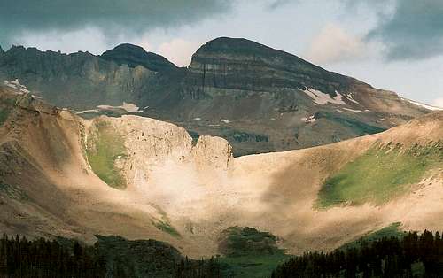
As you drive along U.S. 160 between Cortez and Durango, you will notice some impressive mountains to the north. These are the La Plata Mountains, an arm of the mighty San Juans in southwestern Colorado. Like the rest of the San Juans, the La Platas receive a great deal of snowfall, which helps explain their lush meadows and verdant wildflower displays.
La Plata means “the silver” in Spanish, and I imagine the name has to do with the area’s rich mining history. If anyone can elaborate on that or correct it, please let me know so that I can edit accordingly. Probably because they lack fourteeners and centennial thirteeners, the La Platas are relatively unknown outside the state, and even state residents give these mountains far less attention than they do the higher and more calendar-friendly ranges in the state. The upshot of this is that these mountains offer great opportunities for solitude and exploration-type outings without requiring a tremendous amount of effort to do so.
The La Platas may be small in breadth and stature relative to the San Juans and other ranges in Colorado, but, since they reach 13,232’, remember that they are higher than every other Lower 48 range outside Colorado except for the Sierra Nevada and the White Mountains in California/Nevada, the Uintas of Utah, and the Wind River Range in Wyoming (two Cascade volcanoes and the Grand Teton are higher than anything in the La Platas, but the rest of their ranges don’t approach the heights of the La Platas).
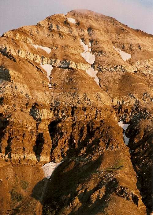
The La Platas are also an exceptionally beautiful range, filled with the coloring and the alpine blooms typical of the San Juans and with interesting geological features; the banded rock found on Hesperus Mountain, Centennial Peak, and Lavender Peak is especially striking.
Hesperus Mountain is the range’s best-known and most-climbed mountain because it is the range’s highpoint and a county highpoint (see this mountain’s page for some interesting information about whether it really is the highpoint), but the other mountains in the range are seldom climbed and make exciting destinations for those interested less in technical challenges and more in alpine rambling and peak bagging. Some notable sights from summits in this range include the well-known San Miguels and Grenadiers to the north and northeast, respectively, and Shiprock in New Mexico, to the southwest. You also get a grand overlook of Mesa Verde country.
 Centennial
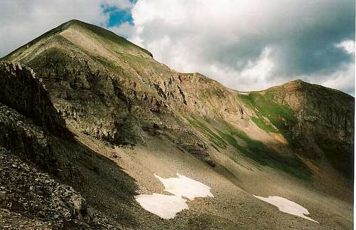 Snowstorm
In short, the La Platas are like a miniature, but not too miniature, San Juan Range, but they are not nearly as busy. They are perfect for those who love beautiful mountains just for their own sake. Note: the topo link locates Kennebec Pass. From there, scroll to examine the area. Most major peaks are west of the pass, but some, such as Cumberland and Snowstorm, are close by.
 Hesperus
Peaks List
Following is a list of all the 12,000'+ peaks in the range. The information listed is as follows: name, latitude/longitude, elevation, prominence, and isolation. SP member John Kirk generously provided this information, and a full list of La Plata peaks can be found in the Comments section of this page.
Hesperus Mountain: 37.445/-108.0889 13232 2852 24.86
Lavender Peak: 37.4416/-108.0811 13220 400 0.49
Moss Mount: 37.4389/-108.0781 13192 292 0.25
Babcock Peak: 37.4295/-108.0792 13180 560 0.81
Spiller Peak: 37.428/-108.0869 13123 183 0.54
Centennial Peak: 37.4471/-108.0769 13062 282 0.44
Diorite Peak: 37.44/-108.0506 12761 461 1.66
Lewis Mountain: 37.422/-108.0145 12740 1120 2.34
Burwell Peak: 37.4208/-108.0904 12664 164 0.9
Snowstorm Peak: 37.4389/-108.0117 12511 331 1.18
Silver Mountain: D 37.3868/-108.0296 12500 1360 2.57
Sharkstooth Peak: 37.4598/-108.073 12462 526 1.34
Cumberland Mountain: 37.444/-108.0042 12388 368 0.54
Indian Trail Ridge: 37.4649/-108.0331 12338 398 1.97
Gibbs Peak B: 37.4097/-108.1023 12286 386 1.89
Deadwood Mountain: 37.3828/-108.0435 12285 265 0.81
Jackson Ridge: 37.4272/-108.1012 12201 261 1.21
12101: 37.4553/-107.9983 12101 361 0.85
Getting There
 From U.S. 550
 From the approach to La Plata Canyon
I have accessed the range from two different places, and it is those two I will describe. If you know of any other good access points, please PM me with a good description, and I will add that to this page.
Sharkstooth Trailhead--- From the western end of the small town of Mancos, follow CR 42 north until it enters the national forest and becomes FR 561. After the Aspen Guard Station, go right on FR 350. Keep right at subsequent junctions (there are two of them) until you reach the signed Sharkstooth Trailhead about 19 miles from Mancos. There is good signage from Mancos. Hesperus Mountain looms above you to the right; it is brilliant at sunset. There are no real campsites at road's end, and there may be sheep around, so sleep in your car or arrive early. The trailhead is at 10,900'. The last mile is somewhat rough but will usually be passable to passenger cars. You might need 4WD early in the season or after a good rain.
Kennebec Pass--- Take the 4WD road up La Plata Canyon to Kennebec Pass and use the Highline Trail. Traveling all the way up La Plata Canyon requires 4WD, but the road is easily navigable for stock SUVs and pickups. It is about 15 miles from U.S. 160 to Kennebec Pass. To get there, exit U.S. 160 ten miles or so west of Durango at Hesperus. The pavement ends after about five miles as the road enters La Plata Canyon. From there, the road becomes progressively rougher as it climbs above timberline to Kennebec Pass at 11,800’. About a mile before the pass, there is an obvious parking area. From this spot, the Highline Trail heads west to nearby Taylor Lake and, from there, deeper into the La Platas and within reach of several summits named and unnamed.
It is possible to make a full-day trip all the way to the Sharkstooth Trailhead, in fact, and get a comprehensive view of the range.
Red Tape
No red tape of which I am aware; I was last there in August 2005.
Camping
There are some campgrounds along the way to Sharkstooth Trailhead and Kennebec Pass. Dispersed camping is widely available.