
-
 25198 Hits
-
 89.39% Score
-
 29 Votes
|
|
Mountain/Rock |
|---|---|
|
|
37.44170°N / 108.0814°W |
|
|
13220 ft / 4029 m |
|
|
Overview
Named for Dwight Lavender, one of the early San Juan Mountaineers, Lavender Peak sits in the La Plata Mountains, a small rugged sub-range of the San Juans. Six named 13ers form the heart of the La Platas, about 15 miles northwest of Durango. Hesperus Mountain is likely the most famous of these, being one of the four sacred mountains of the Navajo. Hesperus has long been considered the highest summit in the range and, thus, the highpoint of Montezuma County. However, field measurements suggested that Lavender may be higher. In 2007, a group including Dave Covill and John Mitchler used sophisticated survey equipment and concluded that Hesperus is approximately 3 feet higher than Lavender. Regardless, Lavender is a striking summit that may be climbed with a short scramble. |  |  |  |  |
Getting There
The Tomahawk Basin trailhead is located on CR 124.From highway 550 in Durango, take highway 160 west for 11 miles and turn north on CR 124. Signs at this turnoff read “La Plata Canyon” and “Kennebec Cafe”. The café is located on the NE corner of the junction.
The first 4.6 miles of CR 124 are paved. Beyond mile 8, the road becomes rougher but may still be passable for 2WD vehicles. At mile 10.4, the road now requires high-clearance/4WD vehicles. At mile 10.6, a small unmarked 4WD road(the “Tomahawk Mine Road”) makes a very hard left with CR 124. This is the Tomahawk Basin trailhead, although there is no parking here.
Options for parking include the Lewis Creek campground at mile 9.7 or small pullouts along the road, the last being at about mile 10.2. There is also a small spot 50 feet beyond the trailhead on the left, which may suffice for one vehicle. Confident 4WD drivers may choose to drive up the rough Tomahawk Mine road and will find a few places to park and camp.
Red Tape
No permits or use fees are necessary to either hike or park in the area. The peak is located within the San Juan National Forest, and backcountry camping is permitted.When To Climb
The best time for hiking is from July through early September. Late spring snowpack and early fall snows may make forest roads impassable outside of this time. Early July may still find Tomahawk Basin heavily laden in snow. In snowy conditions, the peak may become technical and require ice axe, crampons, and rope. Snowshoes and avalanche awareness are necessary in winter conditions.This photo by attm captures all six La Plata 13ers!
 |
Camping
Several campgrounds exist along CR 124, including the Lewis Creek campground (mile 9.7). Camping is permitted in the San Juan National Forest, and there are spots to camp along the Tomahawk Basin 4WD road. After the 4WD road forks at 10800’, places to camp can be found either at the end of the left branch or on the right branch at 11000’ at a large pullout.Lightning, Deer and Snow
The risk of lightning in Colorado must always be considered, especially during the summer months. To minimize lightning risk and maximize the chance of a successful summit, start your hike as early as possible.Use caution when driving the highways and roads to the trailhead. Deer and elk are numerous in the area and can cause fatal accidents.
Contact the Mancos/Dolores Ranger District in Dolores for current information on road and snow conditions. (970) 882-7296
Wildflowers
Numerous wildflowers grace the slopes of Tomahawk Basin. They are plentiful in early summer during snowmelt. |  | 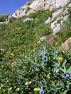 |
External Links
- COHP.ORG
Montezuma County trip reports on the county highpointers website