
-
 14476 Hits
-
 81.84% Score
-
 14 Votes
|
|
Mountain/Rock |
|---|---|
|
|
47.41415°N / 120.87158°W |
|
|
Kittitas/Chelan |
|
|
Scrambling |
|
|
Spring, Summer, Fall |
|
|
6700 ft / 2042 m |
|
|
Overview
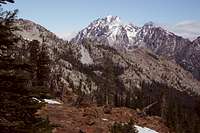 Stuart from North Ridge
 Enchantments from Fourth Pass
Mary's is a fun scramble which can be approached from a variety of directions and combined with other peaks such as Bills Peak, Bean Peak, and Judi's Peak. The gentle nature of its slopes, the ridges which connect it to these other peaks, and the myriad number of trails mean that you can easily climb Mary's Peak one way and come out another. It is therefore a "loop-trip" dream peak.
Mary's is climbed very often, as it lies in a very popular scrambling area, and is also climbed by all field trips of the Mountaineers who conduct their final snow instructional field trip here in the beginning of June. For solitude, come in May or the fall. Otherwise, be prepared to share the peak.
Getting There
 Bills Peak
 North Ridge with Bean Peak
 North Ridge with summit in view
 TOPO! Software Image
From the trailhead, cross Beverly Creek on a bridge and hike 1/2 mile to a ford of Bean Creek and the junction with the Bean Creek Trail #1391.1. From this point on, a number of different routes can lead you to the summit of Mary's Peak. For the most direct route, which involves climbing over a lower summit (Judi's Peak, named for another Mountaineer, Judi Maxwell) just to the south of Mary's Peak, continue over Bean Creek via a ford which is quite easy in summer, but in spring may be quite challenging as the water can be quite high. Follow the Beverly Creek trail a couple of hundred yards after crossing Bean Creek, and find the South Ridge of Judi's Peak directly on your right. Leave the trail and travel off-country up through open pine forest about 1 mile and 2500 feet of elevation gain to reach the summit of Judi's Peak (est. 6600 feet). Continue on this high ridge north another 1/4 mile to reach the summit of Mary's Peak (est. elevation 6700 feet).
To make this a fun loop trip, drop down the Northwest Ridge of Mary's Peak 1 mile to Fourth Pass below Bill's Peak and pick up trail #1226. Follow this trail 1/2 mile south to intersect the Beverly Creek Trail #1391 and follow 2.7 miles until to arrive back at the trailhead. Trip Stats: About 6 miles roundtrip. Elevation gain: 3000 feet. Difficulty: Class 2.
Other Options: Alpine Traverses
 Ridge Traverse to Bean
 Bean Peak
 Climbing Bean
 Ridge Traverse to Bean
Once on top of Mary's Peak, you can traverse its high east ridge over to the summit of Bean Peak, and continue from there down the Southeast Ridge of Bean Peak to Earl Peak (7036 feet). The ridge connecting Mary's and Bean is mostly Class 2 and 3, but there is some Class 4 mixed in as well. To stay entirely on the ridge crest, you will encounter some Class 5 near Bean Peak. To keep it a scramble, once near Bean Peak, descend about 400 feet to Bean Creek basin, then scramble up solid Class 3 rock to the summit of Bean Peak.
The number of connecting ridges to easy peaks, combined with the very good network of trails, can lead to any combination of peaks/loop trips. This trip can be easily customized to your liking. The scramble of Mary's Peak can easily be combined with Bills Peak, Judi's Peak, Bean Peak, Volcanic Neck, Devils Head, and Earl Peak, although obviously not all of them in one day.
Red Tape & Camping
The summit of Mary's Peak lies in the Alpine Lakes Wilderness. Help yourself to a Wilderness Permit at the trailhead. Additionally, a Northwest Trail Park Pass ($5/daily, $30/annually) is required to park at the Beverly Creek Trailhead.Both Bean Creek Basin and Beverly Creek Basin offer great campsites with access to fresh water year round. Camping is particularly enjoyable in Bean Creek Basin, as it remains lush with streams and flowers for most of the summer.
External Links
 Marys Peak from Bean Peak
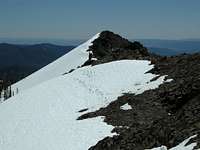 Judys Peak from Mary's Summit
Cle Elum Ranger District
West 2nd Street
Cle Elum, WA 98922
(509) 674-4411
Snow conditions are available from the Summit at Snoqualmie Ski Areas (of which Alpental is one) at the following website:
Summit at Snoqualmie Snow Conditions
Also, webcams are available from the Washington State Department of Transportation at: Snoqualmie Pass Web Cam