|
|
Mountain/Rock |
|---|---|
|
|
47.42053°N / 120.86153°W |
|
|
Scrambling |
|
|
Spring, Summer, Fall |
|
|
6743 ft / 2055 m |
|
|
Peak Overview and Scrambling Routes
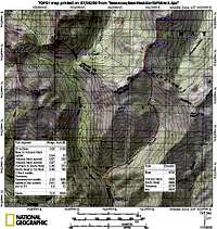
Bean Peak is located in the Teanaway region, sitting at the head of the Bean Creek drainage. You can approach it from any direction, and its southeast, and southwest ridges run to Earl Peak and Mary Peak along the Chelan and Kittitas County line.
The climb from the north is almost a hike. We approached it from the south, via the Bean Creek trail, and got water from the creek before heading north across an open meadow.
Southeast Scramble Route
After traversing on open slopes, we approached the summit from just below the southeast ridge, and encountered mainly 2nd class with a little bit of 3rd class on mainly solid rock. We tended to the left as we got closer to the summit.
I think you can avoid all 3rd class climbing by working around to the left or right. We descended to the north and then ran the ridge to climb Volcanic Neck and Devil's Head.


