


-
 3937 Hits
-
 83.1% Score
-
 16 Votes
|
|
Mountain/Rock |
|---|---|
|
|
45.69130°N / 7.12063°E |
|
|
Aosta Valley Valgrisenche |
|
|
Hiking |
|
|
Spring, Summer, Fall, Winter |
|
|
6083 ft / 1854 m |
|
|
Note
|
La montagna chiama i suoi figli, ed essi rispondono fedelmente al suo appello… Osvaldo Cardellina, Diario alpinistico, 1964-65 Page texts: @ OsvaldoCardellina "Osva", passed away on May 2, 2022. Page owners: Christian Cardellina e Osvaldo Cardellina. Any updates from September 12, 2022: Antonio Giani, page administrator, friend and climbing companion. Testi della pagina: @ OsvaldoCardellina "Osva", scomparso il 2 maggio 2022. Proprietari pagina: Christian Cardellina e Osvaldo Cardellina. Eventuali aggiornamenti dal 12 settembre 2022: Antonio Giani, amministratore della pagina, amico e compagno di salite. |
Wooden Overview
We continue the search for small mountains that do not belong to the "élite". Also Monte Colombo belongs to this series, but only apparently, because as far as the mountain is small not so much as regards the mass, which is significant, but rather for its height certainly not high. At least in respect of the high mountains of the Valley of Aosta. But we used the uncertain "apparently", because in reality this mountain is known and also quite uphill and almost popular. In fact, if we analyze the chain, from Planaval Pass joins him, as indeed is the most popular, at least part of the Walkers and, unfortunately, the hunters of avian fauna, wild boars and chamoises. These last always frequents this area looking, armed to the teeth, to break down these poor animals, who take refuge among the very steep rocky ravines overlying looking for an escape and salvation.
Indeed it is the only one that knows how frequent ascents since Punta Chenal (3.207m), Becca Nera and Bianca of the Paramont (3.262m, 3.261m), the same Mont Paramont, Mont Pit (2.814m) and Mollette Pass, Punta della Crosatie (2.926m) and Hill, Bec Taillà (2.983m), Tour du Tignet or Tighet and Hill (2.976m, 2.533m), Torre Tonda (2.583m; Round Tower) and two Tips of Faveroy Mountaineers of it see very few; because quite challenging or simply because they have too complicated paths on this side of Valgrisa. Factor understandable, because those coming from outside Valle always tries mountains, except with the most resonant names and famous, best known and rewarding and certainly does not commit his limited time in finding these top neglected. But the Monte Colombo "consoles itself" with local Hikers who, like the Becca di Nona, Mont Crammont, Mont Chétif, Mont Fallère, Becca Viou, Mont Zerbion and many others recognize to him the prerogative to offer vast and splendid views to almost 360° view over the complete and entire Valley of Aosta, from the imposing Mont Blanc up there to Matterhorn and to glaciers of Rosa, accompanying with the look of the silvery Baltea, that flowing. Despite his height ...
Continuiamo la ricerca di piccole montagne che non appartengono all'"élite". Anche il Monte Colombo fà parte di questa serie, ma soltanto apparentemente, perché per quanto montagna di dimensioni ridotte non tanto per quanto concerne la massa, che risulta notevole, bensì per la sua altezza non certo elevata. Almeno nel panorama delle alte montagne della Valle di Aosta. Ma abbiamo usato il dubitativo "apparentemente", perché in realtà questa montagna é conosciuta ed anche abbastanza salita e quasi popolare. In effetti, se analizziamo la catena, che dal Passo di Planaval lo raggiunge, risulta anzi come la più frequentata, almeno da parte degli Escursionisti e, purtroppo anche, dei cacciatori di cinghiali e camosci. Anzi risulta come l'unica che conosce continue ascensioni, poiché Punta Chenal, Becca Nera e Bianca del Paramont, lo stesso Paramont, Mont Pit, Punta della Crosatie, Bec Taillà, Tour du Tignet o Tighet, Torre Tonda e Punte di Faveroy di Alpinisti ne vedono veramente pochini; anche perché abbastanza impegnative o semplicemente poiché presentano dei percorsi troppo complicati su questo versante di Valgrisa. Fattore comprensibile, perchè chi proviene da fuori Valle cerca sempre le montagne, se non con i nomi più altisonanti e famosi, più conosciute e gratificanti e certamente non impegna il suo tempo limitato nella ricerca di queste neglette Cime. Ma il Monte Colombo si "consola" con gli Escursionisti locali che, al pari della Becca di Nona, Mont Crammont, Mont Chétif, Fallère, Becca di Viou, Zerbion e tant'altri gli riconoscono la prerogativa d'offrir vasti e splendidi panorami a quasi 360° su tutta la Valle di Aosta, dal Monte Bianco fino laggiù al Cervino ed al Rosa, accompagnando con lo sguardo lo scorrer dell'argentea Dora Baltea. A dispetto dell'altezza ...
 |
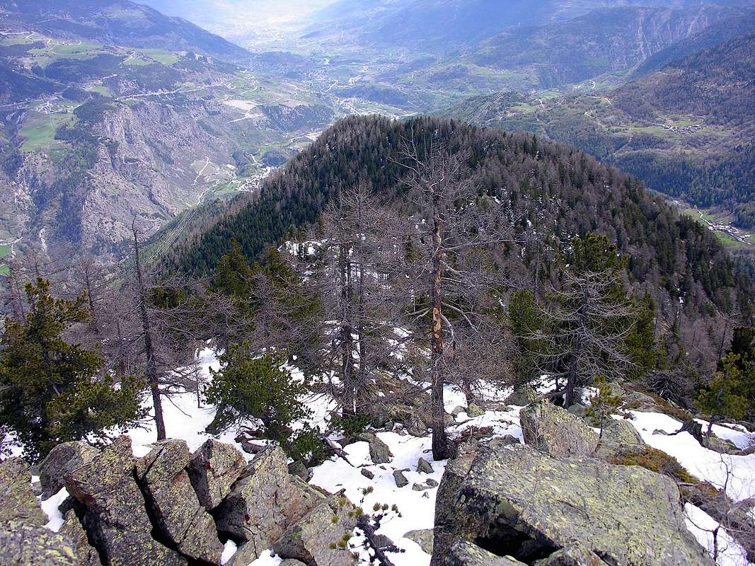
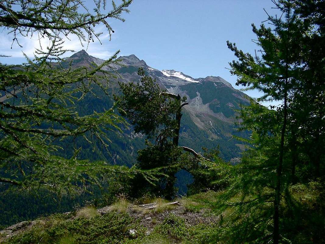
This small mountain is sited at the endo of Mont Paramont (3.300m) Subgroup. The crest of that, starting from Monte Colombo (1.854m) dates back to the Southwest, ending with the magnificent pyramid of Paramont (3.300m), is located along the watershed between that part of the valleys of La Thuile from the high walloons of the Dora Baltea adressed onto the Central Valley. It comes after the squat-wooded promontory of Monte Colombo rocky projected above the Hamlets of Runaz Rochefort-la Ravoire, like a big hump wooded with sinuous, dates back more slender towards the two small Faveroy Summits (2.234m and later to the Southwest 2.254m), with a few drops metres in altitude to the homonymous hill, over the ridge rises again, more imposing, to the Torre Tonda (Round Tower) and then go more towards the West, in the direction of the Tower of Tighet or Tignet, Bec Taillà and Point of the Crosatie. From this point the watershed, after forming the Hill of Mollette (2.774m) is directed more towards the Southwest, and climbed the Mount Pit, ends with its long Ridge Northeast of Paramont. From this point stretches the great divide between the "Valgrisenza" to the East and La Thuile true to the Top of the Testa (Head) del Rutor (3.486m). A long "speech", where the Mount Colombo are the hall and antechamber where you will find only a few Poacher or some Hunter of wild boars. But only in parts "low", since where, starting from Monte Colombo, the ridge becomes more aerial and rocky you will find only the most wild boars. But we are content just to this, because our goals are entirely peaceful and the only prize catch is the one to go home having spent a wonderful day in a natural wild and still not contaminated, at least during this trail because in the North already passes the "civilization". But not here on the opposite side, because this Southern slope more than wild still allows dreaming. "Stealing", maybe, a few images we remain in the heart ...
Questa piccola montagna appartiene alle appendici terminali del Sottogruppo del Mont Paramont (3.300 m). La cresta che, partendo dal Monte Colombo risale a Sudovest concludendosi con la magnifica piramide del Paramont (3.300 m), é situata tra questo lungo divisorio le Valli di La Thuile dagli alti valloni indirizzati sulla Valle Centrale della Dora Baltea. Si presenta, dopo il tozzo promontorio boschivo-roccioso del Monte Colombo proiettato al di sopra degli abitati di Runaz e Rochefort-la Ravoire, come un grande dosso boscoso che, con andamento sinuoso, risale più snello verso la Sommità Nordest delle due piccole Punte di Faveroy (2.234 m, GPS e dopo verso la Sudovest 2.254 m, la più elevata), scende con pochi metri di dislivello all'omonimo colle; oltre la cresta si rialza, più imponente, verso la Torre Tonda per poi proseguire, più verso Ovest, in direzione della Torre del Tighet o Tignet, del Bec Taillà e della Punta della Crosatie. Da questo punto lo spartiacque, dopo aver formato il Colle delle Mollette (2.774 m) s'indirizza maggiormente verso Sudovest e, scavalcato il Mont Pit, si conclude con la sua lunga Cresta Nordest al Paramont. Da questo punto si allunga il grande spartiacque tra la "Valgrisenza" ad Est e la Valle di La Thuile vera e propria insino in Cima alla Testa del Rutor (3.486 m), scavalcando Flambeau, Doravidi e Château Blanc. Un lungo "discorso", dove il Monte Colombo costituisce esclusivamente l'anticamera dell'anticamera e dove troverete soltanto qualche Bracconiere, nasosto nella foresta, o qualche Cacciatore di cinghiali. Ma sol nelle parti "basse", poiché dove, partendo dal Monte Colombo, la cresta si fà più aerea e rocciosa incontrerete soltanto cinghiali. Noi ci accontentiamo sol di questa piccola e semplice escursione, poiché i nostri obiettivi son del tutto pacifici e l'unica preda ambita é quella di tornare a casa avendo passato una magnifica giornata in ambiente naturale ed ancor non contaminato, almeno durante questo percorso poiché a Settentrione già passa purtroppo la "civiltà". Ma questo più che selvaggio versante permette ancor di sognare. "Rubando", magari, qualche immagine che conserviam nel cuore ...
Getting There
BY CAR:
- From TORINO, MILANO, etc: Motorway A5. Exit at AOSTA West (Aymaville) or Morgex Municipalities. From IVREA Town to Villeneuve, Arvier, Pré Saint Didier Municipalities.
- From Liverogne (Arvier) to Valgrisenche From Arvier to Liverogne Fraction (730m) and from this to Valgrisenche Valley, up to the Valgrisenche Municupality (1.664m) and Mondanges, Surier, Us(s)eliéres Villages around the artificial Beauregard Dam, through Regional Road. Mario Bezzi at Vaudet and Chalet de l'Epée Refuges through paths. Specific Road Itinerary From Aosta Town (583m) follow the SS.26 toward Mount Blanc. Once close to the Village of Leverogne (780m), turn left on the Regional Route for Valgrisenche. Pass many small Villages, including Garin (796m), Rochefort, La Ravoire (950m) and, after some 10 kilometres turn to the right toward important Planaval Fraction (1.580m). From Planaval to go back to the North with Municipal Road to La Clousaz Hamlet (1.608m) and the next Village of Baulen (1.775m), placed in an esplanade overlooking the Grisenche Valley and beautiful quick glances on the City of Aosta.
- From FRANCE: through the Mont Blanc Tunnel to Entrèves-crossroads to Vény/Ferret Valleys neighbor the Courmayeur-Resort. By Little Saint Bernard Pass, closed since November until half May to La Thuile Valley - Pré Saint Didier - Courmayeur. It is not necessary to take Motorway A5: you can drive on SS.26, in the direction of AOSTA - IVREA - TURIN.
BY PLANE:
- Aeroporto "Corrado Gex" Saint Christophe (Aosta).
Route
Monte Colombo (1854m) Standard Route:
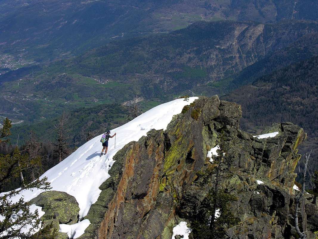
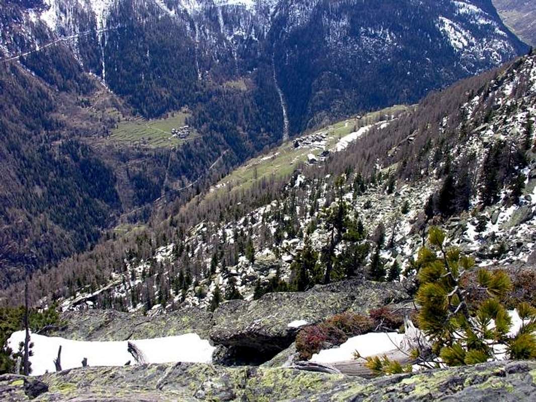
approach and route from Planaval towards Baulen tiny Hamlet: by Planaval Fraction (1.580m), just a short detour on the Regional Road to Valgrisenche Municipality, get to small Villages of La Clusaz (1.608m) and Baulèn or Baulìn (1.775m), always with the paved road. From the small parking, sited amongst the ancient and rustic homes, by taking the path 20A, which rises to the North, crossing a wild forest (with yellow but rare signals), often interrupted by fallen trees across the same, that forcing some small "stunt" passing above or below the logs. Following the same continues further towards the Northeast, reaching the small Village of Milliery (1.656m) and arrives through the forest to the grassy and enough wooden saddle 1.771 meters, from which in the short time, easily crossing towards East, on the Summit (E; 1h'00/1h'15 from Baulen Hamlet).
Monte Colombo (1.854 m) Via Normale:
avvicinamento e via da Planaval al Villaggetto di Baulen: dalla Frazione di Planaval (1.580 m), raggiungibile con una breve deviazione sulla Strada Regionale per il Comune di Valgrisenche, arrivare a quelli di La Clusaz (1.608 m) e Baulèn o Baulìn (1.775 m), sempre con la strada asfaltata. Dal piccolo percheggio tra le rustiche e vecchie abitazioni, prendere il sentiero 20A, che sale verso Settentrione, attraverso la selvaggia foresta (scarse segnalazioni in giallo); questo risulta spesso interrotto da alberi caduti di traverso al medesimo, costringenti a qualche piccola "acrobazia" passando al di sopra od al di sotto dei tronchi. In seguito lo stesso continua maggiormente verso Nordest raggiungendo il Villaggio di Milliery (1.656 m) ed arriva attraversando il bosco all'erbosa ed abbastanza larga sella tra gli alberi 1.771 metri, donde in breve alla Cima (E; 1h'00/1h'15 da Baulen).
Difficulty & Equipment
E/F (Easy and for Hikers).E/F (Facile e per Escursionisti).
Hiking; snowrackets in presence of high snow or not transformed during the winter.
Da Escursionismo; racchette da neve con neve alta oppure non trasformata durante l'inverno.
Mountain Conditions
- You can get meteo information at the official site of the Regione Valle d'Aosta:
- Valle d'Aosta Meteo
Books and Maps
- "Guida delle Alpi Occidentali" di Giovanni Bobba e Luigi Vaccarone C.A.I. Sezione di Torino Volume II (parte II) 25-05-1896.
- "Guida dei Monti d'Italia Alpi Graie Centrali" di Alessandro Giorgetta - Club Alpino Italiano-Touring Club Italiano, 1985 (in Italian).
- "Diari Alpinistici" di Osvaldo Cardellina e Indice Generale accompagnato da Schedario Relazioni Ascensioni 1964-2019 unpublished).
 |
 |
- Kompass "Gran Paradiso Valle d'Aosta" Sentieri e Rifugi Carta turistica 1:50.000.
- Enrico Editore Ivrea-Aosta "Gruppo del Gran Paradiso" 1:50.000.
- L'Escursionista "La Thuile-Piccolo San Bernardo" Carta dei sentieri (n° 2) 1:25.000.
- L'Escursionista "Valgrisenche Val di Rhêmes" Carta dei sentieri (n° 3) 1:25.000.
- I.G.C. Istituto Geografico Centrale Torino "Il Parco Nazionale del Gran Paradiso" (3) 1:50.000.
- I.G.C. Istituto Geografico Centrale Torino "Valsavarenche Val di Rhêmes Valgrisenche P.N.G.P.", 1:25.000.
- Hapax "Les Sentiers Comunità Montana Valdigne-Mont Blanc", 1:50.000.
![To Arp Vieille Damon 2007]()
![Planaval Valley]()
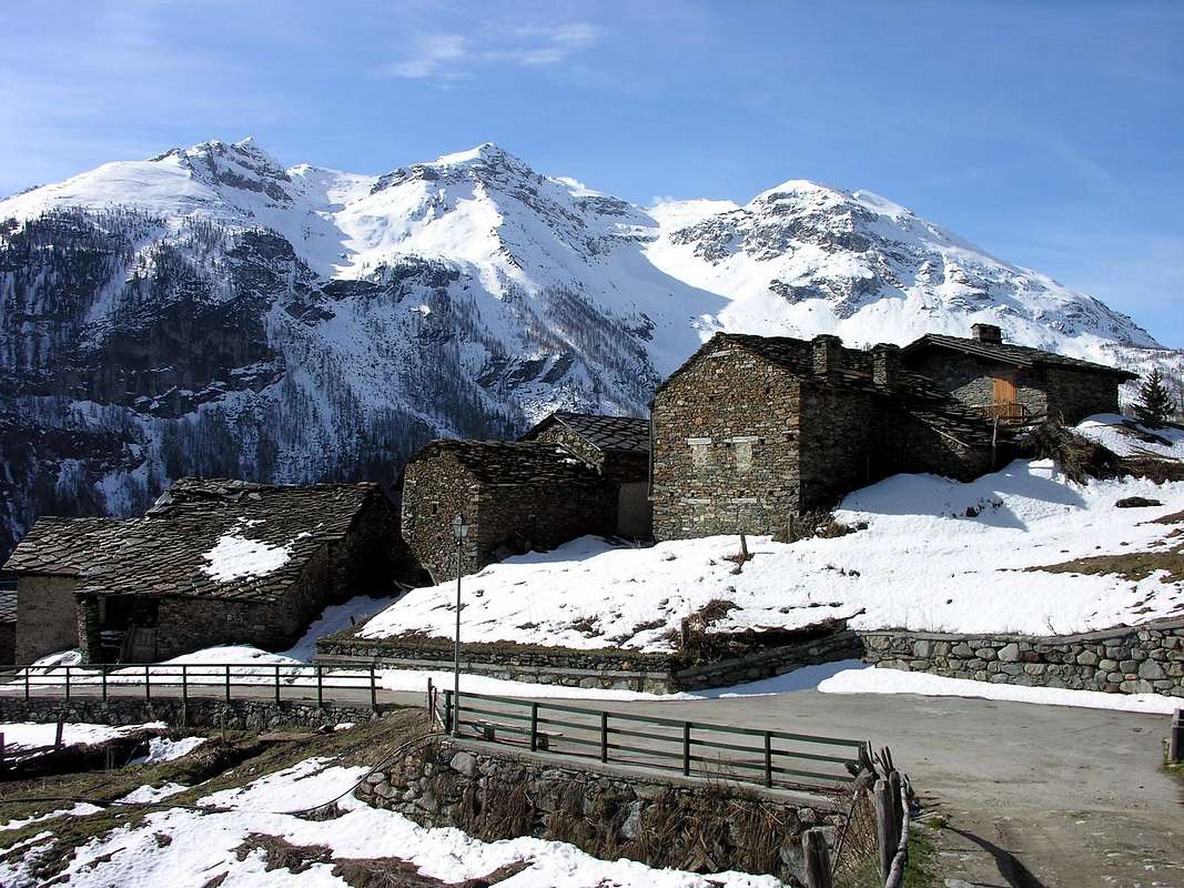
![The old village of Baulen]()
Important Information
- REGIONE AUTONOMA VALLE D'AOSTA the official site.
- FONDAZIONE MONTAGNA SICURA Villa Cameron, località Villard de la Palud n° 1 Courmayeur (AO) Tel: 39 0165 897602 - Fax: 39 0165 897647.
- SOCIETA' DELLE GUIDE DI VALGRISENCHE.
- A.I.NE.VA. (Associazione Interregionale Neve e Valanghe).
Useful Numbers
- Protezione Civile Valdostana località Aeroporto n° 7/A Saint Christophe (Ao) Tel. 0165-238222.
- Bollettino Meteo (weather info) Tel. 0165-44113.
- Unità Operativa di Soccorso Sanitario Tel. 118.