
|
|
Mountain/Rock |
|---|---|
|
|
46.17088°N / 11.45474°E |
|
|
Trentino |
|
|
Hiking, Mountaineering |
|
|
Spring, Summer, Fall |
|
|
8130 ft / 2478 m |
|
|
Overview
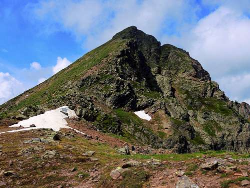
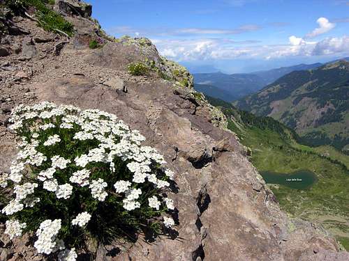
Monte Ziolera 2478 m
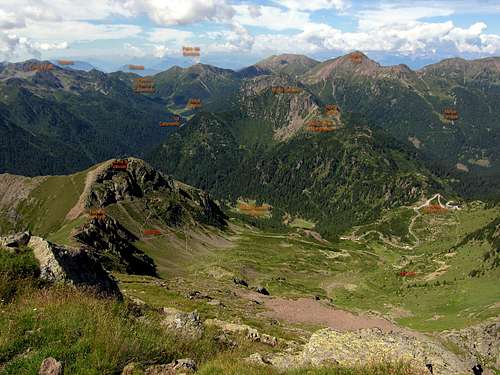
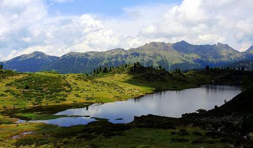
Passo Manghen and the hiking route viewed from the top of Monte Ziolera
Monte Ziolera is a fine pyramid situated in the middle of the Lagorai Group and dominating Passo Manghen from the East. Passo Manghen divides the Western Lagorai chain from the Eastern Lagorai chain. This road pass connects Val Calamento on the Southern side (Valsugana) with Val Cadino on the Northern side (Val di Fiemme). This road is the only high-altitude crossing of the Lagorai chain. Monte Ziolera moreover overlooks the beautiful water mirror of Lago delle Buse. Monte Ziolera is mainly rocky and shows high walls to NW, N and NE. Despite its difficult appearance, Monte Ziolera can be reached by means of a standard route without any mountaineering difficulty starting from Passo Manghen through the Forcella del Frate, a pass that divides Monte Ziolera from the nearby Cima di Valsolaro. From the summit, situated to the East of Passo Manghen, you will enjoy an interesting and large panorama.
Monte Ziolera è una montagna a forma piramidale che domina il Passo Manghen da Est ed è situata nel Gruppo dei Lagorai. Il Passo Manghen divide la catena dei Lagorai occidentali dalla catena del Lagorai orientali. Il passo collega la Val Calamento sul versante meridionale (Valsugana) con la Val Cadino sul versante settentrionale (Val di Fiemme). Questa strada è l'unica rotabile in alta quota della catena dei Lagorai. Il Monte Ziolera si affaccia inoltre sullo splendido specchio d'acqua del Lago delle Buse. E' prevalentemente roccioso e presenta alte pareti verso NW, N e NE. Nonostante il suo ostico aspetto, il Monte Ziolera può essere salito con una Via Normale priva di difficoltà alpinistiche partendo da Passo Manghen attraverso la Forcella del Frate, un passo che separa il Monte Ziolera dalla vicina Cima di Valsolaro. Dalla cima, situata a est di Passo Manghen, il panorama è ampio e interessante.
Getting There
by car from North: autoroute A22 (Brennero-Modena): get out at Egna-Ora and follow SS48 looking the table to Castello di Fiemme; then along the SP31 (Passo del Manghen)till the pass (small parking area).
•by car from South: autoroute A22 (Brennero-Modena): get out at Trento Centro and follow SS47 (Valsugana) till Borgo Valsugana. Then look the table to Passo del Manghen pass, that you reach by the SP31 (Passo del Manghen) till the pass.
•by train from north: Ora station (railway Monaco-Roma) - Borgo Valsugana East Station (railway Valsugana, Trento-Venezia). Info: 1678/46047 - web site in italian Trenitalia-IT and in english Trenitalia-EN. From here bus services are avaiable till Cavalese.
•by train from south: Trento station (railway Monaco-Roma) - Borgo Valsugana East Station (railway Valsugana, Trento-Venezia). Info: 1678/46047 - web site in italian Trenitalia-IT and in english Trenitalia-EN. From here no bus services but only private taxi!
•by bus from north: using the public services of Società Atesina (a branch of Trentino Trasporti) starting from Ora and going to Cavalese. No services till Passo del Manghen! See also the South Tyrol-Alto Adige bus services at SAD. But also here from Cavalese till Passo del Manghen pass only taxi service!
•by bus from south: using the public services of Società Atesina (a branch of Trentino Trasporti) starting from Trento till Borgo Valsugana. No services till Passo del Manghen! •nearest airports: in Verona Aeroporto Valerio Catullo; in Venezia Aeroporto Marco Polo; in Milano Aeroporti di Linate e Malpensa; in Bergamo Aeroporto Orio al Serio; in Bolzano-Bozen Aeroporto di Bolzano.
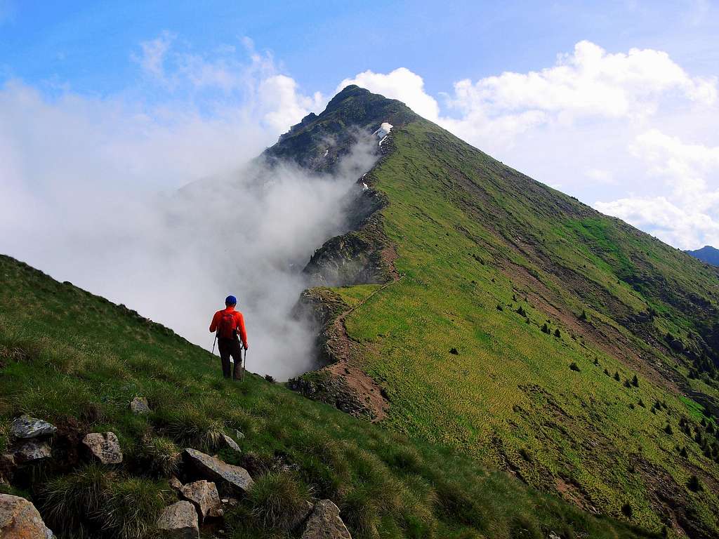
Monte Ziolera Normal route
English version Starting point: parking lot on Passo Manghen m. 2047. The path SAT 322 leaves the asphalted road and it heads towards East in light climb. With some hairpins it makes a wide turn towards right to catch up the Forcella del Frate staple m. 2228 which divides Monte Ziolera to the left from the small Cima di Valsolero to the right. The path continues here on the left along the crest of Monte Ziolera reaching directly the top m. 2478. Easy and beautiful.
Italian Version Si parte direttamente dal Passo Manghen (m. 2047). Il sentiero SAT 322 lascia la strada asfaltata e si dirige verso est in lieve salita. Con ampio giro verso destra raggiunge la Forcella del Frate (m. 2228) che divide il Monte Ziolera a sinistra dalla piccola Cima di Valsolero sulla destra. Dalla forcella il sentiero prosegue a sinistra lungo la cresta del Monte Ziolera giungendo direttamente sulla cima (m. 2478). Facile e remunerativo.
Hiking grades of difficulty
T - Turistico (Tourist): Itineraries on wide, clear and well worn paths, sometimes on mule tracks or gravel roads. The routes are never exposed, don't give any orientation problems and don't exceed 2500 meters of altitude. Suitable also for children
E - Escursionisti (Hikers): Itineraries on marked trails, even narrow and with possible steep and impervious sections. They are never exposed and don't give any orientation problems. They can tread different kinds of ground, such as forests, gravel, meadows, pastures, easy rocks, etc.). They form the majority of the trails that wind up in the mountains and require a certain habit to walk; you need equipment suitable for the altitude and resistant footwear with soles suitable for rough terrain
EE - Escursionisti Esperti (Experienced Hikers): Itineraries for hikers with experience and good knowledge of the mountain. Some of these paths may have exposed sections, however brief, which require firm foot and no dizziness. They require the ability to adapt to particular terrain, such as steep grassy slopes or stretches of rocks with difficulties that can reach the 1st degree of the UIAA scale. They can also reach high altitudes (3000 m or more). Sometimes they may include unmarked sections, requiring a good sense of orientation. Snow slopes are possible, however which can be overcome without specific mountaineering gear (rope, harness, crampons, ice-axe)
EEA - Escursionisti Esperti con Attrezzatura (Experienced Hikers with equipment - The same as EE, in addition these routes require the use of via ferrata equipment (lanyards, harness, carabiners, heat sink, helmet). This kind of itineraries range from the trails with short easy and not much exposed sections, previously equipped with fixed ropes and iron pegs, to the true and more difficult Via Ferratas climbing on rocky walls or on aerial ridges and ledges, previously equipped with long stretches of iron ropes, iron steps, ladders without which proceeding would constitute a real climbing. It is necessary to know how to use the technical equipment and have a certain habit of exposure and mountaineering terrains.
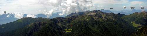
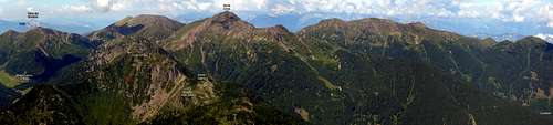
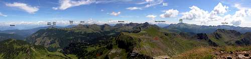
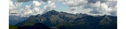
Summit panorama
Here we have four panorama from the top: click on the image to have avaiablity to the links into SP locations.
Panorama from the top toward SW |
Panorama from the top toward NW |
Panorama from the top toward NE |
Panorama from the top toward East |
Red Tape
The numeration and maintenance of the paths in this zone is performed by the local Alpin Club (S.A.T.= Club of the Mountain climbers of the Trentino). Every path SAT is marked with white-red colours and a number. In this web page SAT XXX indicates the presence of a marked path SAT on the terrain with white-red signs and tables.
The numeration of the roads into the Trentino means this: Axx means autoroute; SSxx means state road, SPxx means provincial road.
The small valley Valtrigona, situated between the 1,600 and the 2,200 meters of altitude, is first Oasis WWF with alpine characteristics. More notices here.
This zone is lend inside to numerous easy but generally remunerative excursions of the immensest area wilderness of the Trentino. Alpine shelters are least, but us it can be taken advantage of bivouacs and mountain barns restructured from the local communities for hiking use. For its beauty and running water presence I would to recommend like easy objective (1 hour from the Passo del Manghen pass) the Bivouac ANA Telve, that you can easy catch up by path SAT 310 towards west.
When to climb
Best season goes from middle May to middle October
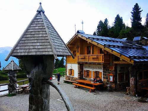
Where to stay
Bibliography

•Advised cartography: Kompass n. 621 (Val Sugana-Cima d'Asta-Val dei Mocheni) 1:25,000
•Advised book: Mario Corradini, Lagorai Cima d'Asta, Touring Editore, Milano 2006 - a complete and exaustive guide to the hiking and mountain's paths into the most large wilderness-area of Trentino. Edited by the Touring Club Italiano in collaboration with the Club Alpino Italiano (the official italian alpin club).
•Advised book: for news wide and deepened on the course of the forehead and the military operations in the zone, it is indispensable to refer to the historical work of Walther Schaumann: "La grande guerra 1915-18, Volume 3 - Prealpi Venete e Trentine", Ghedina & Tassotti Publisher Limited, Bassano del Grappa (Italia), 1984 (this is the italian version of the original “Schauplaetze des Gebirgskrieges - Oestliche Dolomiten, Sexten, Cortina di Ampezzo”. Colonel Walther Schaumann also has founded the association Friends of the Dolomites that has cured the arrangement of trenches and distances of war.
•local tourist office
•local mountain meteo