
-
 20581 Hits
-
 84.27% Score
-
 18 Votes
|
|
Mountain/Rock |
|---|---|
|
|
51.56460°N / 116.466°W |
|
|
Mountaineering |
|
|
Spring, Summer, Winter |
|
|
10735 ft / 3272 m |
|
|
Overview
Mount Balfour is a grand and glorious peak presiding over the Waputik Icefield. The summit lays along the Continental Divide is essentially half in Alberta (Banff National Park) and half in British Columbia (Yoho National Park). The summit reaches an impressive 3272m (10,735 ft.), and although nowhere near tall enough to be included on the highly sought Canadian Rockies 11,000’ers list, this inspiring peak is high on many ski mountaineer’s wish list since is halfway along the famous Wapta Traverse high glacier ski traverse. The mountain is almost entirely surrounding by major glaciers (Waputik Icefield, Diableret Glacier and Trolltinder Glacier) and provides aesthetic classic moderate mountaineering routes in a magnificent alpine setting.Mount Balfour is the twelfth highest peak in Yoho National Park (11th if you consider Mount Goodsir as one summit) and approximately the 47th highest in Banff National Park. Mount Balfour was named by Palliser Expedition member James Hector in 1859. John Hutton Balfour was a professor of botany at Glasgow University, Dean of the medical school at the University of Edinburgh and also became Regius Keeper of the Royal Botanic Garden Edinburgh and Her Majesty's Botanist in 1845. He held these posts until his retirement in 1879.
The Palliser Expedition (officially titled the British North American Exploring Expedition) explored and surveyed the open prairies and rugged wilderness of western Canada from 1857 to 1860. The purpose was to explore possible routes for the Canadian Pacific Railway and discover new species of plants. The expedition was led by John Palliser. Doctor Balfour provided much encouragement to the Palliser Expedition. Mount Balfour was first ascended in 1898 by C.L. Noyes, Charles S. Thompson, and G. M. Weed from Hector Lake to the South-East Ridge. First winter ascent in 1936 on skis by G. Lillienfeld and M. Read from camp at Bow Lake.
Getting There
 Balfour Approaches
Located on the Continental Divide, Mount Balfour can be approached from either Alberta via trailheads in Banff National Park or from British Columbia and Yoho National Park. Typically, ski mountaineers will access Mount Balfour from Banff National Park and the Banff/Jasper highway 93, and summer mountaineers from the end of the Yoho River Valley/Takakkaw Falls Road in Yoho National Park, 13.0 km from the Trans-Canada Highway near Field, B.C. If skiing the full Wapta Traverse, usually a vehicle will be parked at the Peyto Lake parking area in Banff National Park (or Bow Lake for a shorter traverse) and a vehicle at the Sherbrooke Lake trailhead in Yoho National Park.
From Calgary drive west 165 km on the Trans-Canada Highway to Lake Louise in Banff National Park, from Canmore drive west 81 km to Lake Louise. From Golden, B.C. drive east 60.5 km, past Field, to the seasonal closure of Yoho River Valley/Takakkaw Falls Road in Yoho National Park or 80.0 km to Lake Louise.
Bow Lake/Bow Hut and Wapta Icefield Approach
Most straightforward and most used approach to the Wapta Icefield and Mount Balfour. From Lake Louise drive west 3 km on the Trans-Canada Highway to the Banff/Jasper Highway 93, drive north 37.7 km to the Bow Lake turnoff, then another 400 metres to second parking area.
Hector Lake Approach
By far the least used approach, best in the winter/spring when Hector Lake is frozen and skiable (only a partial trail on the south shore of Hector Lake, could paddle it though). Not used very often and likely you will be breaking a trail on skis, but provides the most direct and shortest approach to the R.J. Ritchie (Balfour) Hut. From Lake Louise drive west 3 km on the Trans-Canada Highway to the Banff/Jasper Highway 93, drive north 21.0 km to the Hector Lake/Creek roadside pull off. This is a small pull off that is not signed, located on the left (east) side of the highway and usually plowed clear in the winter/spring.
Yoho River Valley/Takakkaw Falls Approach
If only climbing Mt. Balfour, this approach would likely only be used for summer mountaineering (July to September). Late September to late June the Yoho River Valley/Takakkaw Falls Road is closed. From Lake Louise drive west 22.2 km on the Trans-Canada Highway to Yoho River Valley/Takakkaw Falls Road turnoff. From Golden, B.C. drive east 60.5 km on the Trans-Canada Highway, past Field, to Yoho River Valley/Takakkaw Falls Road turnoff. Drive this scenic road to end (13.0 km) and park in the busy Yoho Valley trailhead area.
Red Tape / Camping and Bivouacs
All national parks in Canada require an entrance fee. No permit or fee is required to climb in Banff or Yoho National Parks. A voluntary safety registration system is available for climbers in the Rocky Mountain National parks. It is necessary to register in person at the park information centres or warden offices during business hours. On completion of the excursion, the party must notify the park by telephone or by returning the registration form.Up to date information about climbing and mountaineering in the Rocky Mountain National parks available at: Rocky Mountain National parks | Climbing and Mountaineering
During the ski season, up to date avalanche bulletins for Banff, Yoho and Kootenay National Parks available at: Avalanche Bulletin - Banff, Yoho and Kootenay National Parks
Climbers are permitted to bivouac on long routes or otherwise where necessary to safely complete a climb. Some restrictions apply; mostly prohibiting the most popular peaks. A backcountry use permit is required for any overnight stay, contact any Banff or Yoho National Park visitor centre, where you may obtain the permit. An overnight stay in an Alpine Club of Canada backcountry hut still requires a permit from Parks Canada, but the alpine club can charge the fee and provide a permit.
 Balfour Hut
Mount Balfour, and most of the Wapta and Waputik Icefields, are well served by several high alpine huts operated by the Alpine Club of Canada. Near Balfour Pass, below the north glacier slopes of Mt. Balfour, the R.J. Ritchie Hut provides the perfect base to ski or climb the most popular ascent routes on Mt. Balfour. The R.J. Ritchie (Balfour) Hut is located at 51.591666, -116.455 (NTS UTM grid reference 375157) elevation 2470 metres and requires payment and reservations in advance from the Alpine Club of Canada. During the busy spring ski season on the Wapta, booking on weekends can be very difficult since prime weekends are booked well in advance, and ACC members have priority.
Summer mountaineers will often approach Mt. Balfour from the Yoho Valley and climb Mt. Balfour as a day trip, but there are many excellent bivy sites along the southern glacier/ice field edge. Typical a bivouac campsite is south of the peak, near the edge of the Waputik Icefield (Approximately NTS UTM grid reference 390090 (51.530892, -116.438042)).
Approach
Bow Lake/Bow Hut and Wapta Icefield Approach
 Heading up headwall
Most straightforward and most used approach to the Wapta Icefield and Mount Balfour. From the Bow Lake parking area ski across the lake (or use the trail on the north shore if not frozen), over the inlet flats then up a slight hill near the stream originating from the Crowfool Mtn./St. Nicholas Peak col, traverse south 50 metres, then descend back to creek (this avoids a tight canyon crossing on a natural rock bridge) then enter the canyon of the creek (this section of ski approach exposed to unseen avalanche slopes).
Ski up out of the canyon, short steep side hill, then a raising traverse south through thinning trees to the spectacular basin ringed by large seracs below St. Nicholas Peak. The cliff walls to the right (west) open into an easy scree/snow slope heading directly west. This steep gully provides direct access to Bow Hut.
From the Bow Hut head directly west, then south-west onto the Wapta Icefield, gaining a steep headwall, once on the flat icefield, round the west side of St. Nic (crevasses near shoulder of St. Nic) to the St. Nicholas Peak/Mt. Olive Col. From the col, descend the Vulture Glacier east, then south-east to the toe of the glacier, the R.J. Ritchie (Balfour) Hut is just off the southern end of the glacier.
 West side of St. Nic West side of St. Nic |
 Mt. Olive Mt. Olive |
 Nearing Balfour Hut Nearing Balfour Hut |
|---|
Hector Lake Approach
By far the least used approach, but the lower glacier bench ascent route provides the most direct and shortest approach to the R.J. Ritchie (Balfour) Hut. From the pull off ski down to Hector Lake, ski to the lake inlet, up the narrowing valley of Balfour Creek. Nearing the head of the valley, turn left (south) and gain the Balfour Glacier. You can access the glacier bench north of Mt. Balfour from a lower route or an upper route closer to Lilliput Mountain. The lower route is shorter, but has higher crevasse hazards, the upper route requires more elevation gain to the lower point between Balfour and Lilliput, then to Balfour High Col.
 Skiing Balfour Glacier Skiing Balfour Glacier |
|
| Friends of mine used the Hector Lake route to return to the highway after skiing up Mount Balfour, they enjoyed untracked powder and a great run down the Balfour Glacier into Balfour Creek, but they had to break trail across Hector Lake and had to thumb for a lift back to their car parked at Bow Lake, a risky proposition on a dark night on a quiet highway in the winter; recommend leaving two cars along Highway 93 if making a circuit from Bow Lake/Bow Hut to Mt. Balfour and out Hector Lake. |
|---|
Yoho River Valley/Takakkaw Falls Approach
If only climbing Mt. Balfour, this approach would likely only be used for summer mountaineering (July to September). Late September to late June the Yoho River Valley/Takakkaw Falls Road is closed. From Lake Louise drive west 22.2 km on the Trans-Canada Highway to Yoho River Valley/Takakkaw Falls Road turnoff. From Golden, B.C. drive east 64 km on the Trans-Canada Highway, past Field, to Yoho River Valley/Takakkaw Falls Road turnoff. Drive this scenic road to end (13 km) and park in the busy Yoho Valley trailhead area. The South-East Ridge is often reached from the Yoho Valley in summer months, cross the Yoho River near the Takakkaw Fall parking lot, ascend the main gully south of the falls to the Daly Glacier, and follow the north margin of the glacier to the South East Ridge.
When to Climb
Typical Canadian Rockies situation; best conditions for a ski approach and ski ascent is usually from December to April (earlier means less snow of course), and with July to September usually providing the best conditions for high elevation summer climbing (later means less snow of course).Route Descriptions
 Mt. Balfour Routes Mt. Balfour Routes |
|
Excellent route information published in the out print “The Rocky Mountains of Canada South”, Boles, G.W., Kruszyna R. & Putnam W.L. (1979) guidebook.
| Canadian climbing and skiing legend Chic Scott has authored many ski mountaineering guide books that provide great information regarding the Wapta Icefield and Mount Balfour. Chic’s guidebook, Summits & Icefields 1 | Alpine Ski Tours in the Canadian Rockies, was recently updated and provides the best information regarding Mt. Balfour. |
|---|
 Upper SE Ridge Upper SE Ridge |
|
- South-East Ridge, Alpine II
| The line of the first ascent, the first winter ascent, and the standard contemporary normal route. Historically, parties gain the South-East Ridge lower down near the low point closer to the summit of Lilliput Mountain, or from the Daly Glacier if approaching from the Yoho Valley; today most parties will gain the ridge closer to Mt. Balfour. |
|---|
.
In 1898 C.L. Noyes, C. S. Thompson, and G.M. Weed approached from Hector Lake, followed south shore, ascended scree on west side of valley, past Margaret and Turquoise Lakes to foot of Balfour Glacier/ Waputik Icefield, up glacier and traversed south-west to the Balfour/Lilliput col. Up long and winding broad ridge to final narrow summit ridge over broken rock and steep snow to the summit. 1936 was the first winter ascent of mountain by by G. Lillienfeld and M. Read via SE ridge from camp at Bow Lake, to St. Nicholas Peak/Crowfoot Mtn. Col, then to Vulture Glacier and Balfour Pass, skied to Balfour/Lilliput col then up SE ridge to the summit.
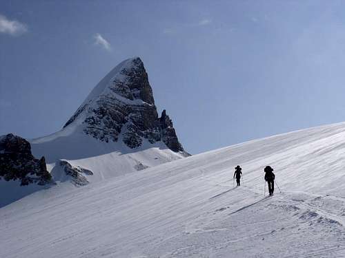
These days the majority of parties ascent Mt. Balfour from the Balfour High Col (UTM GR 386119) 51.556755, -116.444608), often as part of the Wapta Traverse. Typically from a night spent at the R.J. Ritchie (Balfour) Hut or the Scott Duncan Hut. The glacier terrain from Balfour Hut to the Balfour High Col is the most demanding and unforgiving on the Wapta Traverse and it is recommended that travel only be undertaken in favorable conditions with stable snow and good visibility.
 Enroute to High Col Enroute to High Col |
 Nearing Col Nearing Col |
 View to top View to top |
|---|
From the Balfour Hut, ascend the Waputik Icefield in the general direction of the Balfour High Col, staying to the right of a large cliff band on the glacier. Approach the cliff band from its left side, before turning right and ascending a ramp along its base; turn left again at its crest and head toward the Balfour High Col. The High Col can be hazardous in both summer and winter. There are crevasses on the slope heading toward the col, and danger of serac icefall on the right from Mt. Balfour; don’t stop for lunch in this area. The route from the Scott Duncan Hut is all on glaciated terrain, without serac icefall danger and less steep, until near the Balfour High Col.
 Ski drop Ski drop |
 Snow gully Snow gully |
 Summit party Summit party |
|---|
The upper South-East Ridge is quite jagged and provides slow and intricate travel. Most parties forgo this upper section and drop to the glacier south of the ridge crest which allows one to ski nearly to the summit. From the High Col ski west about 500 metres along the broad South East ridge, then drop about 50 metres down steep scree and low angled rock to the glacier below the South East Ridge, ski north-west towards the summit, the slopes steepens towards final summit block, ski to steep rock/snow slopes and ascend steep snow gully to summit ridge, then about 50 metres along South East Ridge to summit. Return the same way.
 North Ridge North Ridge |
|
- North Ridge, Alpine II
| First ascent of route July 1904 by G Benham, C. Kaufmann. From Yoho River Valley, up Diableret Glacier, before reaching Balfour Pass, turned right, east, and ascend steep snow slopes to the North Ridge, then follow ridge to summit. |
|---|
.
 West, North-West Rib West, North-West Rib |
|
- West, North-West Rib, North Ridge, Alpine III, 5.7
| First ascent of route July 1978 by C . Israelson, D. Bouchard and C. White. This climb is on the prominent buttress that rises from the ridge between the Diableret and Trolltinder Glaciers. From bottom of buttress, seven pitches of 5.7 lead to the North Ridge, about 500 metres from the summit, then followed ridge to summit on snow and ice, descended the same route with several rappels. Likely this route has not been repeated. |
|---|
.
 North-East Face North-East Face |
|
- North-East Face, Alpine III
| First ascent of route August 1964 by G. Boles, A. Cole, G. Geber and R. Geber. From Bow Lake, to St. Nicholas Peak/Crowfoot Mtn. Col, then to Vulture Glacier and Balfour Pass. Up glacier directly below summit of Mt. Balfour, directly up crevassed icefall to North Ridge, 60 metres traverse along ridge to summit. Descent by SE Ridge. No record of this direct route being repeated. |
|---|
.
Reference
Summits & Icefields 1 | Alpine Ski Tours in the Canadian RockiesBoles, G.W., Kruszyna R. & Putnam W.L. (1979). The Rocky Mountains of Canada South. 7 th edition. New York: American Alpine Club, Alpine Club of Canada. Out of print