
-
 12129 Hits
-
 80.49% Score
-
 12 Votes
|
|
Mountain/Rock |
|---|---|
|
|
50.73000°N / 115.30456°W |
|
|
Mountaineering |
|
|
Spring, Summer, Fall, Winter |
|
|
10610 ft / 3234 m |
|
|
Overview
Mount French is a major mountain in the high backcountry of Kananaskis with a summit elevation of 3234 metres (10,611 ft.). Named by Morrison P. Bridgland in 1915 for the Earl of Ypres, John Denton Pinkstone French. Field Marshall John French commanded the British Forces during the first sixteen months of World War I and was named first Earl of Ypres in 1922. The mountain was first ascended in 1921 by H.S. Hall Jr., M. Morton Jr., guided by Edward Feuz Jr.. This significant peak is almost entirely surrounded by glaciers; the Haig, French and Smith-Dorrien Glaciers. Of the ten or so mountain ranges in the Kananaskis region, Mount French ranks third highest in elevation; only exceeded in height by Mt. Joffre (3450m) and Mt. Sir Douglas (3406m).Many use the term “Kananaskis Country” in reference to a variety of different areas, but generally this large region includes the foothills to the continental divide (Alberta/British Columbia provincial border) from Banff National Park south to the Highwood River drainage. The region includes eleven official mountain subranges/groups, but there is some overlap between ranges and groups; the Joffre Group (French Military Group), the Spray Range (British Military Group), the Kananaskis Range, the Goat Range, the Opal Range, the Fisher Range, the Misty Range, the Elk Range, the Highwood Range, the High Rock Range and the Livingstone Range.
Mount French is the second highest summit in the Spray Range (British Military Group). Mount French is nestled against the Haig Glacier and shares a famous col with Mount Robertson. The French/Robertson (Glacier) ski traverse is a very popular ski tour and travels along French Creek and French Glacier to this col.
Getting There
 |
Very likely anyone visiting Mount French will approach from Alberta and Peter Lougheed Provincial Park. Best access from Calgary via Trans Canada Highway west to Highway 40 (Kananaskis Trail) south to the turn off for Kananaskis Lakes, approximately 50 km south of the Trans Canada Highway. Travel about 2.2 kilometres to a T-intersection and turn north onto the Smith-Dorrien road. Trailhead parking is located along the Smith-Dorrien road, approximately 20 km north of the Kananaskis Lakes area, at the Burstall Pass trailhead. Rougher road, but best access from Canmore is via Smith-Dorrien road. From the Canmore Nordic Centre, travel south about 41 kilometres to the Burstall Pass parking lot. |
|---|
 |
Access to the French/Robertson col requires extensive glacier travel and considerable approach time on these glaciers and should only be attempted by experienced mountaineers. Hike or ski the trail towards French Creek, head south along the creek to the French Glacier to the Mt. French/Mt. Robertson col (col approximately 11km from trailhead). |
|---|
Red Tape / Camping and Bivouacs
Once a true wilderness area, the backcountry regions of Peter Lougheed Provincial Park has become extremely busy and popular. This has required increased regulation of the backcountry in the last 10 to 15 years in an attempt to sustain the healthy ecosystem and wildlife populations. Peter Lougheed Provincial Park only allows backcountry camping in designated backcountry campgrounds and no random backcountry camping is allowed. There are no designated backcountry campgrounds in the French Creek drainage. No permit is required to park or climb in this park. The approach and route are short enough to allow completion without a bivouac.Up to date information about Peter Lougheed Provincial Park available at:
Peter Lougheed Provincial Park
When to Climb
 |
Typical Canadian Rockies situation with July and August providing the driest conditions. Later summer and early fall (October) can provide dry conditions. The South Ridge has been climbed in the winter (First recorded winter ascent of the mountain by R. Bonney; B. Saunders; R. Collier, February 19, 1989). |
|---|
Approach
Trailhead parking is located along the Smith-Dorrien road at the Burstall Pass trailhead. Follow the Burstall Pass trail, well signed, to the signpost at the top of the first hill, about 500 metres. Go straight onto the French Creek logging road, descends into the French Creek Valley. The old logging road fads fast, a variety of slight trails exist, generally stay left (looking upstream, east side) of the creek. In the winter there will be a clear ski track. |
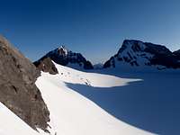
Once in view of the French Glacier stay left, east, especially in the winter. Follow a series of moraines and eventually gain the glacier near UTM GR 192214 (50.731877, -115.311986). The East Face of Mount Robertson gets a lot of spring morning sun and often avalanches to the French Glacier surface in the trough, low draw of the valley. Once on the glacier, easy hike or ski to col. The glacier is usually snow free by July since the winter wind often blows it clear, sometimes requiring crampons even in the winter. A few and narrow crevasse are visible, but usually easy to avoid. |
|---|
 |  |
| A beautiful glacier moat that wraps the South-East flank of Mount Robertson signals the start of the Haig Glacier and the Mt. French/Mt. Robertson col, approximately 11km from trailhead. Head south-east onto the Haig Glacier to eye the easiest and safest line up the south slopes, eventually aiming for the skyline of the South-West Ridge, up scree or snow dependent of time of year. | |
|---|
Route Descriptions
The terrain of the south slopes, from the South-West Ridge line (above French/Robertson Col) to the South-East Ridge, are relatively straightforward, once off the Haig Glacier, and a variety of lines are possible. Staying to the prominent ridgelines of the SW or SE ridge provides the easiest route finding and best rock quality.- South-East Ridge/South Ridge, Alpine II
First ascended in August 1921 by H.S. Hall Jr., M. Morton Jr., guided by Edward Feuz Jr. From a camp on Maude Brook, gained the southern toe of the Haig Glacier and north to the col between Mt. French and Mt. Jellicoe. Follow South-East Ridge over easy, but rotten rock to the southern low peak, then gained the summit South Ridge. Along South Ridge up and over a few steep steps (4 class) then a long, very exposed narrow ridge is encountered just before the summit block. Loose and narrow, but 4 class climbing gains the summit block, easy rock to summit. Descended the same route.
- South Slopes/South-West Ridge/South Ridge, Alpine II
 |  |
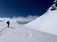
| First ascent of this variation unknown, recommended route, shortest approach and easiest winter access. Up French Creek and Glacier to French/Robertson Col. From col head onto Haig Glacier, head south to avoid difficult section of lower South-West Ridge. Up southern slopes, to South-West Ridge to southern low peak. Gain the summit South Ridge, along South Ridge up and over a few steep steps, about 50 horizontal metres before the summit block, a narrow, very exposed ridge section is reached. Loose and narrow, but 4 class climbing gains the summit block, easy rock to summit. Descend the same route. | |
|---|
- South Slopes/South-West Ridge/South Ridge/East Face, Alpine II
Variation used by R. Collier et.al. on winter ascent in February 1989. Skied up French Creek to French/Robertson Col, then up South-West Ridge to southern low peak, then gained the summit South Ridge. Along South Ridge up and over a few steep steps, avoided step before summit by rappelling onto snow slope on east side of ridge, then climbed snow to summit block, returned the same way.
- North Ridge, Alpine II
 |
First ascent of route by W. Saville, D. Collins and three others (not referenced) August 1969. From camp in French Creek, climbed broad North-West Ridge of Mt. French outlier, GR 196222 (“Prairie Lookout”) (50.739917, -115.304390, 3190m (10,466 ft)) with difficult class 4 climbing to summit of “Prairie Lookout”. From this summit, continued on knife-edge rock ridge (North Ridge) to summit of Mt. French, descent by the same route. |
|---|
Reference
Boles, G.W., Kruszyna R. & Putnam W.L. (1979). The Rocky Mountains of Canada South. 7 th edition. New York: American Alpine Club, Alpine Club of Canada.Out of print
R. Collier trip report online at bivouac.com