
-
 4367 Hits
-
 79.04% Score
-
 10 Votes
|
|
Mountain/Rock |
|---|---|
|
|
52.20872°N / 117.44505°W |
|
|
Mountaineering |
|
|
Spring |
|
|
11024 ft / 3360 m |
|
|
Overview
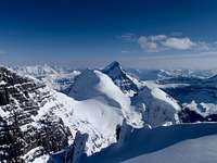
'West Twin' (GR 696844) is dwarfed by its huge neighbours, North Twin (3730m, 12,237 ft.), South Twin (3580m, 11,745 ft.) and Twins Tower (3640m, 11,942 ft.), but with an impressive height of 3360m (11,023 ft.) it is a significant and striking mountain. This summit is not officially named, but is quite separate from its immediate neighbour, South Twin. From the col between 'West Twin' and South Twin there is about 120 metres of prominence to the summit of 'West Twin' and about 900 metres of isolation from South Twin to 'West Twin' summits.
 |
 |
| View to col between 'West Twin' and South Twin |
East Face of 'West Twin' |
The first ascent was an impressive solo adventure. The South Couloir route was a bold solo climb in a very remote location by Dane Waterman in July of 1975. The South Couloir ends at the South Twin/'West Twin' col, where the East Face route was climbed to the summit of 'West Twin'; and subsequently the North Ridge to the summit of South Twin.
 The Twins area map
North Twin and South Twin, The Twins, were named by pioneer mountaineer Norman Collie in 1898 after his and Hermann Woolley’s first ascent of Mount Athabasca, the first recorded view of The Twins. 'West Twin' is an unofficial name for the highpoint just west of South Twin. Twins Tower was officially adopted as a name in mid 1900’s for the striking tower north of North Twin. Today, many local mountaineers associate the name, The Twins, with these four 11,000 foot plus summits. Some might also include the unofficial, local name of 'Son of Twin' (GR 692867) a prominent 3270m (10,728ft.) high point outlier on the North West ridge of Twins Tower, but this obscure summit has likely only ever seen one ascent.
Getting There
‘West Twin’ (GR 696844) is approached from the Icefield Parkway (Banff-Jasper Highway (Highway 93)). Depending on the route, the approach is from the Athabasca Glacier for the standard route or from Woolley Creek/Woolley Shoulder/Habel Creek/Athabasca River for the rarely climbed South Couloir route.From Calgary drive west 165 km on the Trans-Canada Highway to Lake Louise in Banff National Park. From Canmore drive west 81 km to Lake Louise. From Lake Louise drive west 3 km on the Trans-Canada Highway to the Banff/Jasper Highway 93, drive north 125 km to “Columbia Icefield Discovery Centre” and the toe of the Athabasca Glacier.
If heading to the base of the South Couloir route (only one reported ascent of this route) park as for the Woolley Creek approach. Drive an additional 15 km north to a pull out on the east (right) side of the highway (same parking area and approach beginning as Diadem Peak, Mt. Woolley and Mt. Alberta). Long approach via Woolley Creek/Woolley Shoulder/Habel Creek/Athabasca River to the source of the Athabasca River at the toe of Columbia Glacier.
Red Tape / Camping and Bivouacs
All national parks in Canada require an entrance fee. No permit or fee is required to climb in Jasper National Park. A voluntary safety registration system is available for climbers in the Rocky Mountain National parks. It is necessary to register in person at the park information centres or warden offices during business hours. On completion of the excursion, the party must notify the park by telephone or by returning the registration form.Up to date information about climbing and mountaineering in the Rocky Mountain National parks available at:
Rocky Mountain National parks | Climbing and Mountaineering
During the ski season, up to date avalanche bulletins for Rocky Mountain National parks available at:
Avalanche Bulletin - Jasper National Park
Avalanche Bulletin - Banff, Yoho and Kootenay National Parks
Climbers are permitted to bivouac on long routes or otherwise where necessary to safely complete a climb. Some restrictions apply; mostly prohibiting the most popular peaks. A backcountry use permit is required for any overnight stay, contact any Jasper National Park visitor centre, where you may obtain the permit. Most parties will bivy or camp near the North Twin/Stutfield Peak col and ascend North Twin and Twins Tower, then South Twin and “West Twin”, the following day.
Approach
Most straightforward and most used approach to ‘West Twin’ (GR 696844) is from the Athabasca Glacier. From the toe of the glacier parking area, or if the short access road is closed (not ploughed in the winter), from the highway side parking lot, ski towards the toe of the Athabasca Glacier.At the toe of the Athabasca Glacier head up the right side (northern edge) towards a ramp that provides access to the Columbia Icefield, the ramp base is about 5 km from the toe.
 |
 |
 |
| Toe of Athabasca Glacier |
Base of ramp | Near top of ramp to Columbia Icefield |
Once on the Columbia Icefield the southern edge of Snow Dome must be circumnavigated; generally stay south of the big and obvious crevasses on the south east slopes of Snow Dome, heading west, then angling north, north-west. The Columbia Icefield is not flat, and a serious of glacier hills and valleys are traversed as you head north to your objective.
 |
 |
 |
| Skirting Snow Down | Heading north to Twins | Long ski to base camp |
Generally to ascend any of the The Twins (North Twin, South Twin, Twins Tower or “West Twin”) the base camp should established as close as possible to The Twins/Stutfield Peak Col, about 52.223, -117.408.
 |
 |
 |
| Nearing the bivy site | Camp view to Stutfield Peaks | Camp view to Twins |
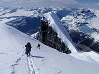
From The Twins/Stutfield Peak Col, about 52.223, -117.408 head west, North Twin and its broad South and South-East slopes are very accessible from the col, Twins Tower is usually ascended from North Twin, South Twin and “West Twin” require a traverse south of North Twin to reach their standard routes.
 |
 |
 |
| South slopes of North Twin | View to Twins Tower Col | Traversing south of North Twin |
When to Climb
Typical Canadian Rockies situation; best conditions for a ski approach and ski ascent is usually from January to May (earlier means less snow of course), and with July to September usually providing the best conditions for high elevation summer climbing (later usually means less snow of course). Most parties ski/climb ‘West Twin’ (GR 696844) in May on the standard route.Route Descriptions
‘West Twin’ (GR 696844) only has one documented route, the East Face. Only one recorded ascent by South Couloir route (first ascent, but finished on the East Face route), so only the standard approach and climb from the South Twin approach is described.The South Couloir was a bold solo in a very remote location by Dane Waterman in July of 1975. South Couloir ends at the South Twin/”West Twin” col, where the East Face route was followed to the summit of “West Twin”on the first ascent.
Canadian climbing and skiing legend Chic Scott has authored many ski mountaineering guide books that provide great information regarding the Columbia Icefield and North Twin. Chic’s guidebook, Summits & Icefields 1 | Alpine Ski Tours in the Canadian Rockies, was recently updated and provides the best information regarding ‘West Twin’ (GR 696844)
- East Face, Alpine II
The line of the first ascent, the first winter ascent, and the standard contemporary normal route. Most parties will camp near The Twins/Stutfield Peak Col, 52.223, -117.408 and traverse south of North Twin and gain the col between North and South Twin, then onto the East Face of ‘West Twin’ (GR 696844).
This low angled snow face gets steeper as you gain elevation, but the elevation gain in only about 120 metres. Cornices are usually present on the summit ridge and can provide a challenge if large, often the case. Once on the summit ridge, a simple snow walk to the summit, descend the same way.
 |  |  |
| East Face | Mid way up face | OSWB on summit |