Page Type Page Type: Mountain/Rock
Location Lat/Lon: 34.41499°N / 112.40451°W
Additional Information County: Yavapai
Activities Activities: Mountaineering
Seasons Season: Spring, Summer, Fall, Winter
Additional Information Elevation: 7979 ft / 2432 m
Sign the Climber's Log

Overview


Mount Union View
Mount Union View

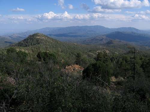
Mount Union is the highest point of the Bradshaw Mountains, a major range that sits nearly dead-center in the state, east of Prescott and visible from Phoenix. The Bradshaws were the first mountains to be exploited for mineral riches, and gave birth to the city of Prescott, back when the territory was part of New Mexico. 

An ascent of Mount Union is very easy. Good roads come within a mile of the peak, and most passenger cars can handle these roads in dry conditions. There are quite a few residents who live in the forest near the mountain. 

The peak gets its name from Union sympathizers during the Civil War. A nearby peak, Mount Davis 7,900', had been named in honor of the Confederate President, Jefferson Davis. Both sides had men working the mines to support the Union or Confederate causes.  Mount Union can easily be combined with Mount Davis.

Mount Union is the highest point in Yavapai County and its proximity to population and good roads make it fairly popular.  There is a lookout tower that is sometimes open, but during 2020 has been closed due to the pandemic. 

(Primary photo by Dennis Poulin)


Getting There

There are a handful of ways to get close to the peak.

Easiest:

In Prescott, locate yourself near downtown's famous Whiskey Row, either on Sheldon Street (AZ-89) or Gurley Street, which parallels Sheldon Street. Find Mount Vernon Road and turn south, aiming for the hills. You pass through some homes, and soon, the street is renamed the Senator Highway. Stay on this road until it leaves town, enters into the Prescott National Forest, and becomes well-graded hardpack dirt. Continue south on the Senator Highway as it wiggles through the forest. Ignore the many side roads that junction with it. Pay attention to the signs at the junctions. You eventually come to a junction where a right continues south as the Senator Highway leads toward Crown King, and a left leads toward Mount Union. This is Forest Road 261, and this junction is about 12 miles from Prescott.  Continue up this road for 1.5 miles to where it forks with FR-261A. This is a spur that leads to the summit, but it will likely be gated. You can park and hike from here. This route is open to most vehicles in dry conditions. The last portion of FR-261 can be a little rough in spots.

Common alternative routes:

From Prescott Valley along AZ-69, you can head south on Walker Road. This road turns to dirt near Lynx Lake (a popular camping area). Stay southbound on this road through the forest towns of Walker and Potato Patch. You need to pay attention as the roads intermingle and are not always signed. When in doubt, stay on the "major" road. The road will bypass Hassayampa Reservoir and it gets a little rough here. It then descends and meets with the Senator Highway. Make a left and soon you come to the junction with FR-261. Proceed as above.

From the west via AZ-89: From Prescott, drive about five miles south on AZ 89. Turn left when you reach the green road sign that says: Wolf Creek - 6 miles. This is County Road 101. Drive southeast on the good dirt road. After six miles, you'll reach the Wolf Creek Campgrounds. About a half mile past the campgrounds, you'll reach the junction with the Senator Highway. Mount Union is about seven miles from here, and the intersection elevation is 6,300'. If you want to hike Mount Union, this would be a good place to park. Otherwise, you can continue driving up the mountain. You can drive to within a mile of the summit before you hit a locked gate.

For Phoenix hikers looking to double Davis and Union - 

From Poland Junction north of Mayer: Catch FR-261 from the east along AZ-69 in the locale of Poland Junction. Drive about 10 miles west to the junction with Big Bug Mesa Road.  High Clearance 2WD can make it here.  Any further, and 4WD is mandatory.  However, a loop can be done with an offshoot to Davis by hiking the FR 261 west for just over half a mile to the 285 ATV road.  Take a right and head up to the saddle between Davis and Union.  It's an easy bushwhack less than 0.4 miles to the summit of Mount Davis 7,900'.  Head back to the saddle, and go a little over 3/4 miles to the summit of Union.  Come off of Union down the road until you reach a junction back with the FR 261 and take a left and it's a little over 2 1/2 miles back.  This is a 6 mile loop.  

Rougher route for the adventurous or foolish:

From Crown King: First, get to Crown King, via Interstate-17 at the Bumble Bee Exit, then west 26 miles to Crown King. Catch FR-52 and follow it north for 25 miles to its intersection with FR-261. In 2003, this road was rough but manageable. In 2011, there were sections of this road that were extremely rough, and fit only for Jeeps. I suspect the Forest Service is not actively maintaining these roads.
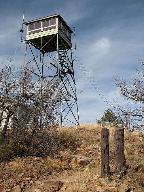
Mt. Union LOMt. Union LO (by Eric Noel)


The Senator Highway

This dirt road was built in the 1860s to connect Prescott, then the Arizona territorial capital, to the small but growing city of Phoenix. Today, it is "maintained" by the Prescott National Forest, where is is designated Forest Road 52. Its termini are in Prescott south of Gurley Street, and at Interstate-17 at the Bumble Bee Exit, about 65 miles in all.

Scott Surgent and his wife drove it from Bumble Bee through Crown King to Prescott in January 2003. They drove his stock 2001 Nissan Frontier. He had it in 4-wheel drive most of the way, but recalled the road being "decent". In 2011, he drove part of this road again, about five miles out of Crown King to Hopper Saddle near Horse Mountain. This section of road was in abysmal shape. Here is his trip report on that adventure.

Here is a detailed description from AllTrails.com.


Mountain Conditions

Contact the Bradshaw Ranger District in Prescott at 520-443-8000 for the latest information.


Forest Service Map: Prescott National Forest.
Topo Map: Groom Creek.

The peak can be climbed all year. Summers are pleasant, but prone to thunderstorms. Winter "ascents" are possible, if the roads have been plowed open. The Bradshaws get a fair amount of snow, and some of these roads may be closed for days or weeks at a time.  Ideally, spring and fall months are the best times to hike here.  Fall colors come in October.

Camping

There are several developed campgrounds in the Bradshaw Mountains. Options include the Upper and Lower Wolf Creek Campgrounds, and the Lynx Lake Campground. You may also free-camp, but beware that the forest around Mount Union is "developed", including many private lots. You might have better options farther south, or off of the main roads onto the lesser roads.

Mt. UnionMt. Union


External Links

Prescott National ForestPrescott National Forest CampingArizona Prominence Map


Children

Children

Children refers to the set of objects that logically fall under a given object. For example, the Aconcagua mountain page is a child of the 'Aconcagua Group' and the 'Seven Summits.' The Aconcagua mountain itself has many routes, photos, and trip reports as children.