
|
|
Mountain/Rock |
|---|---|
|
|
44.60910°N / 117.2785°W |
|
|
7120 ft / 2170 m |
|
|
Overview
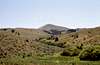
Big Lookout Mountain is an isolated peak with a significant 3,120 ft. of prominence, which places it #16 in Oregon. It rises over 4,600 feet above valley near Durkee, where it dominates the skyline and 5,000 feet above Eagle Valley to the north. The well formed pyramid is separated from the Cuddy Mountains of Idaho by the deep Snake River Canyon and from its larger neighbors, the Wallowas by 25 miles across the low Powder River valley. Due to its isolated nature and height Big Lookout Butte is one of the most visible mountains in the inland northwest being seen from the eastern Oregon deserts to the mountains of central Idaho.
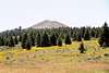
The mountain supports a mixed conifer and aspen forests with both a lower and upper timberline between the arid juniper/sage rangelands below and the windswept grassland above. Along the road to the mountain at least four vegetation zones can be seen. There are some outcrops on the upper reaches, but generally the mountain is a steep, but relatively easy walkup from any of the access points. It is common to see mule deer and elk in this area. A gated, twisting primitive road turns off the main road and accesses the summit and its lookout with various telecommunications equipment. This road can be hiked or ignored to ascend the summit cone.
 |  |  |  |  |
Getting There
Take the 338 exit off from I-84 and follow the rough Lookout Mountain road. There are turnoffs, but continue on the main road, following the signs to the mountain. At approximately 15 miles in there is a gated road that turns off to the left and climbs to the summit. There is room for one car to park here. If this is not available, continue on a few hundred yards to where the main road crosses the east ridge of the mountain for more parking spaces. From here the road can be walked back or the east ridge climbed to the summit. From the main road to the summit is a 920 foot vertical climb over a horizontal distance of 0.4 miles.
The mountain can also be reached from the north. Leave I-84 at town of Durkee (exit 327) and turn east. Take the first right that will parallel the freeway to the south. This starts as a nice paved road, but most of the way is graveled or native surface. Stay on this road for approximately 15 miles to the divide between Big Lookout Mountain and the ridge to the north (Lookout Mountain). From here continue east taking the road that cuts south and climbs the northeast flank of the mountain. This becomes the road described above and can be followed back to the freeway for a good loop road. This northern route is a much rougher road and may not be suitable for all vehicles. Much of it passes through private land and from the nature and number of signs in the area, the owners don't want travelers getting off the road.
 |  |  |
Red Tape
None. However, there is a lot of private land in the area. If you plan on leaving the main road be sure of the ownership. A map with this information is recommended.
When To Climb
May until the late fall snows get deep (Oct or Nov).
Camping
There are no developed campgrounds near this mountain. Undeveloped campsites can be found at numerous places along the road or off on the secondary roads. Ownership is very mixed with the public BLM lands and private lands forming a checkerboard pattern over much of the area. It would be best to obtain a map from the BLM office at Baker City to know exactly where to camp.
Mountain Conditions
NOAA Forcast