
|
|
Mountain/Rock |
|---|---|
|
|
37.09300°N / 118.545°W |
|
|
12321 ft / 3755 m |
|
|
Overview
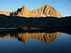
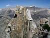
Isosceles is named after its geometric symmetry, visible only from certain directions. Located in the High Sierra, this peak is climbed infrequently: probably no more than once every 3-4 years or so. Isosceles is adjacent to Columbine Peak, sharing a ridgeline. Nearby peaks such as Mt. Winchell, Thunderbolt, Starlight, and the North Palisades attract more attention. However, the views from Isosceles' summit are outstanding. It is an excellent, pleasurable "easy-day" outing from either Dusy Basin or Palisade Basin.R.J. Secor's book, "The High Sierra: Peaks, Passes, & Trails" (2nd ed; 1999) has an excellent "signature photo" showing the overall geometric shape on page 231. Thank you to SSSdave for the signature photo above.
There is a summit register (plastic container; tucked deep into the summit rocks).
 |  |  |  |  |
Getting There
USGS: North Palisade Quad 7.5 minute series---------------------------------------------------------------------------------------
Beginning in the town of Bishop, California, drive about 15 miles on Highway 168, turning onto South Lake Road. Drive 5.8 miles to South Lake & the trailhead; this road follows the South Fork of Bishop Creek and passes several resorts.
Isosceles is most easily accessed via the Bishop Pass Trail, one of the most heavily utilized trails in the High Sierra. Permits are required; use quotas are in effect from May 1 to November 1.
Bishop Pass Trail starts from the parking lot of South Lake (9,000 feet). It is a very busy place with limited overnight parking. An overflow lot is 1.5 miles back down the road.
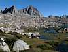
After about 5 miles on a broad, well-traveled trail, many steep switchbacks lead to the summit plateau of Bishop Pass (11,960 feet) and the entrance to King's Canyon National Park and the wilderness boundary. Follow the trail, then eventually wander cross-country down into Dusy Basin (~11,380 feet).
Another option is to cross Bishop Pass heading towards Dusy Basin. About 200 feet below Bishop Pass, head left and hike cross-country. Contour around Mount Agassiz and Mount Winchell. Cross Thunderbolt Pass into Palisade Basin, which has good areas for camping. After contouring around Peak 12,548, head towards Isosceles Pass; it separates Isosceles Peak from Columbine Peak and Columbine's Northeast Ridge (which is a pleasant, class 2-3 climb over stable talus and boulders). Isosceles is NNE of Columbine; they share a ridgeline.
Isosceles Pass (12,080 feet) is 0.1 mile south of Isosceles Peak and is an alternative to Knapsack Pass. The Dusy Basin side is rated class 3; the Barrett Lakes side is class 2. Secor states that Knapsack Pass is easier than Isosceles Pass.
The indolent climber can hire pack animals to haul gear up into the area, but pack animals are not allowed to stay overnight in Dusy Basin. Bob Burd helpfully clarifies: "This includes the national park as well. Pack mules are considered 'traditional use' along with horses in Wilderness areas, and can be used on most trails. Craig Peer's recent trip into Dusy Basin is such an example."
Red Tape
A quota system for both Bishop Pass and the North Fork of Big Pine Creek is in effect from May 1 to November 1. Permits can be obtained from the ranger stations in Lee Vining, Bishop, or Lone Pine. Permit applications may also be done via mail or fax.Overnight permits are required to access the backcountry at all times.
Advance reservations are *highly* recommended, especially for Bishop Pass: it is one of the most popular trails in the High Sierra. The Inyo National Forest website has wilderness info including quotas, reservation availability and permit applications.
Wood campfires are not permitted in Dusy Basin (or anywhere above 10,000 feet in King's Canyon National Park).
When To Climb
Isosceles can be climbed any time of year...but of course, summer is the easiest. During late summers snow may still be near the base but ice axes are not needed.Camping
Dusy Basin offers a number of excellent campsites. One option includes the flat perimeter somewhat near the sandy shores of the various lakes. Large boulders nearby are good for food storage, and also serve as after-dinner bouldering problems.Campsites are also available on the southeast side of Isosceles, in Palisade Basin.
Mosquitos are vicious! Don't forget the DEET! During mosquito season a hat with netting down to the shoulders and a netting shirt are priceless commodities.
Water is not a problem, even in late season: it can be obtained from the various lakes, or from the streams that feed them.
There are no huts.
Route Overviews
Southwest Face (class 5)First ascent July 1939.
Southwest Buttress (II, 5.6)
First ascent 19 August 1995. Ramp, roof, and blocks. See "routes" for detailed info.
West Chute (II, 5.7)
First ascent July 1991. Up a chute, through a tunnel in the ridge, then a 5.7 crack.
West Face (II, 5.9)
First ascent August 1978. Central crack & chimney system.
West Face, Right Side (II, 5.7)
First ascent 24 October 1998.
Northeast Face (class 3 with class 4 summit block)
First ascent July 1938
Southeast Ridge (5.4)
See "routes" for detailed info.
 |  |
External Links
- Isosceles region photos
Romain Wacziarg has posted a number of photos from this region, including the approach via Bishop Pass and his climb of Columbine Peak, adjacent to Isosceles. Isosceles & Dusy Basin are included in several of Romain's photos.