
-
 12740 Hits
-
 92.04% Score
-
 37 Votes
|
|
Mountain/Rock |
|---|---|
|
|
46.80182°N / 11.39593°E |
|
|
Hiking, Scrambling, Via Ferrata |
|
|
Summer, Fall |
|
|
8875 ft / 2705 m |
|
|
Overview
 Sarntaler Weißhorn as seen from Penser Joch (photo by wuedesau) Sarntaler Weißhorn as seen from Penser Joch (photo by wuedesau) |
The Sarntal Alps are a remote mountain range, not so much because they are hard to get to but because many of their principal summits are located deep within the range so that day tours are barely feasible. Moreover quite the elevation differences you have to surmount are formidable even though the highest mountains of the range don't even reach 2800m. Hirzer, the highest one, measures 2781m and there are a handful of other ones getting close to that margin. And then the range is embedded in the higher and more important Stubai, Ötztal and Zillertal Alps, which draw visitors and thus leave the Sarntal Alps mountains quite solitary. There are exceptions, however. Everywhere where you can find road passes, cable cars or ski lifts you can be sure to meet great amounts of people.
Sarner Weißhorn (also Sarntaler Weißhorn, Italian: Corno Bianco) is one of these mountains. Located at most two hours west of Penser Joch / Passo di Pennes it is a popular hiking and climbing destination. It is a beautiful pyramid and especially when seen from Penser Joch there is no question why it is called a "horn". The name "Weißhorn" probably can be explained by the large marble inlay in its southern slope, since the rest of the mountaiin is rather reddish or brownish. Sarner Weißhorn dominates the northern central part of the Sarntal Alps, though in fact it is the lowest of the 2700ers of the range. Still there are no equally high mountains close by which makes the mountain a great lookout peak.
 |  | 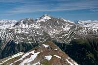 |
When seeing the mountain for the first time from Penser Joch you might ask yourself how the summit can be obtained as it looks like an inaccessible vertical peak - a clear trick of perspective. It can be climbed by any sure footed hiker which is in part due to the fact that a mini ferrata has been established in the south face. Four or five 10 - 20m stretches have been equipped with solid steel cables, leading directly through the face. In my opinion the protection has been overdone but two memorial plaques for fallen mountaineers can be found to the side of the route so that I suppose there might be conditions in which you might need all of them.
 |  |  |
The whole climb from Penser Joch doesn't take more than 2 1/h hours one way - and you have to hike slow to take that long. Therefore it is recommendable to do the hike back across the neighbouring easy peaks of Röthenspitze /Punta Rossa (2441m) and Ganskragenspitze / Punta di Campo (2322m). Also, neighbouring Zinseler / Cima di Stilves (2422m) can be added, all of which offer great views. If that is not enough, start the ascent from Jaufental Valley / Valle del Giovo, either from Mittertal / Val di Mezzo or Obertal /Valle di Sopra. In both cases you will have to scale more than 1500m to reach the summit of Weißhorn.
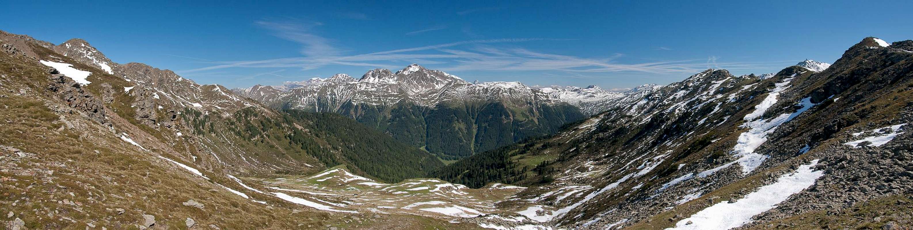
Panoramic view
Tribulaun GroupTelfer WeißenEtschenspitzeRollspitzeZinselerRöthenspitzeGanskragenspitzeP f u n d e r e r B e r g eTatschspitzeSulzspitzeTagewaldhornNebelseesp.PaulswandHohe ScheibenJakobspitzeTeufentaler SpitzeKarnspitzeMudatschKreuzjochVerdinser PlattenspitzeHirzerAlpler SpitzeUnterbergHochwartÖtschspitzeHohe KreuzspitzeJaufenspitzeHochplattspitzeMareiter SteinS t u b a i A l p s   |
Getting There
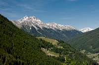
 Sarner Weißhorn above Penser Tal
The mountain can be easily reached from the Brenner Motorway A22. Take the exit Sterzing / Vipiteno and follow the signs for SS508 in direction Penser Joch / Passo di Pennes.
The two trailheads in Jaufental / Valle del Giovo can be reached via the road to Jaufenpass / Passo Giovo (SS44), which you have to leave at Gasteig / Casateia in direction of Jaufental / Valle del Giovo.
Red Tape
There is no red tape in the Sarntal Alps. There are a couple of cattle fences between Penser Joch and Weißhorn so in case you have to cross any please close the gates.Not sure where to put this but: the road to Penser Joch / Passo di Pennes (SS508) is very popular among motorcyclists, some of whom seem to sport suicidal ambitions. Both driving a car on the road or crossing it on foot can be real dangerous, much more than climbing the mountain.
Accommodation
 |
Rooms and Apartments
Eisacktal / Valle Isarco
Passeiertal / Val Passiria
Burggrafenamt
Camping
- The closest campground is at Gasteig / Casateia in Ratschingstal / Valle di Racines to the north of the mountain. The campground is called "Gilfenklamm" and is located on SS44 to Jaufenpass / Passo del Giovo.
Huts
- There are no real huts close by but you can use the hotel/restaurant at Penser Joch / Passo di Pennes. Also in Pens / Pennes to the south of the mountain several inns can be found.
Weather Conditions
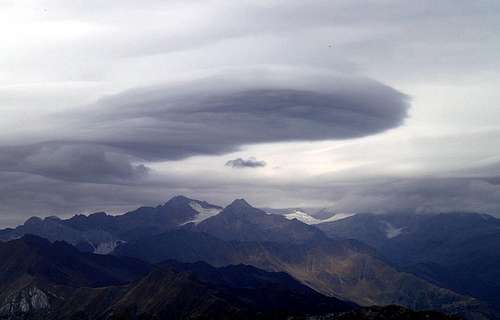 UFO above the Stubai Alps. Seen during the descent from Weißhorn
Maps & Books
Maps
- Digital Maps
- Regular Maps
- Sarntal/Val Sarentino
Kompass Map WK 056
1:35.000
ISBN: 3-85491-340-0
- Sterzing / Vipiteno
Kompass Map WK 44
1:50.000
ISBN: 3-85491-050-9
- Brixen / Bressanone
Kompass Map WK 56
1:50.000
ISBN: 3-85491-063-0
- MONTE SARENTINI / SARNTALER ALPEN
Tabacco Map 040
1:25.000
- Sarntal/Val Sarentino
Books
- Meran-Burggrafenamt
Franziska Baumann
Kompass Guidebook WF951
Kompass Verlag
ISBN: 3-85491-386-9
- Rund um Sterzing
Henriette Klier / Walter Klier
Rother Verlag
ISBN: 3-7633-4167-6
- Rund um Meran
Henriette Klier
Rother Verlag
ISBN: 3-7633-4290-7