
-
 8277 Hits
-
 86.85% Score
-
 23 Votes
|
|
Mountain/Rock |
|---|---|
|
|
46.61487°N / 11.46114°E |
|
|
Skiing |
|
|
Spring, Summer, Fall, Winter |
|
|
7415 ft / 2260 m |
|
|
Overview
 Rittner Horn / Corno di Renon from Villanderer Alm / Malga Villandro Rittner Horn / Corno di Renon from Villanderer Alm / Malga Villandro |
The range of the Sarntal Alps / Monti Sarentini is a horseshoe shaped mountain range with its opening almost directly in the south. The highest mountains of the group are located to the north and as you move southward the mountain range runs out in two broad ridges, which both end about 800m above the city of Bozen / Bolzano. The eastern one of these ridges, known by the name of Ritten / Renon (which both describes the geography as well as the habitation of the area) is the more popular of the two, mainly due to the fact that it is located vis-à-vis the Dolomites with only the narrow Eisacktal Valley / Valle d'Isarco in between. There are two signature mountains for the area, Villanderer Berg / Monte Villandro, which towers above Sarntal Valley / Val Sarentino and Rittner Horn / Corno di Renon, located in the centre of the range.
For a signature mountain Rittner Horn / Corno di Renon is surprisingly unspectacular - even ugly. Like all of its neighbours it is made up from porphyry, a part of the Bozen / Bolzano porphyry plate, a huge slab of several hundred metres thickness. The whole of the Ritten area is made up from this rock and Rittner Horn / Corno di Renon stands out among it. "Standing out" in this region means that a broad back rises above the plateau of Villanderer Alm / Malga Villandro. There are smaller faces all around the summit, reaching some 100m in height, which consist of porphyry blocks. There is a mountain hut and a radio tower on top of the mountain, both greatly diminishing the attractiveness.
 |  |  |
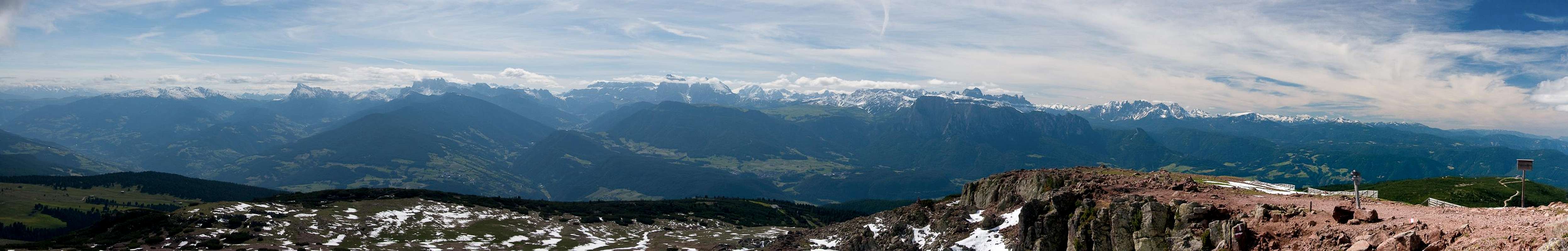
Still, Rittner Horn / Corno di Renon is one of the most popular mountains of the Sarntal Alps / Monti Sarentini and it truly stands out among them. The reason? Arguably it is the best lookout pulpit from which to observe the western Dolomites. At 2260m its summit is above the timber line and with only the Eisacktal Valley / Valle d'Isarco separating it from the westernmost outpost of the Dolomites its position is truly exceptional. From Peitlerkofel / Sas da Pütia in the north to Latemar in the south - the whole western subgroups are on display and on fine days you can see right across the whole range towards the Cortina and Sexten / Sesto Dolomites.
 |  |
The popularity of the mountain is increased by the fact that a cable-car runs up from Klobenstein to the neighbouring summit of Schwarzseespitze / Punta Lago Nero. Here a summit restaurant caters to all needs. The regular hike from the cable-car to Rittner Horn / Corno di Renon takes little more than 30 minutes but a panoramic trail, which winds through the east faces of both mountains is the longer but more popular alternative. From here you can see dorn into the valley some 1400m below.
Rittner Horn / Corno di Renon is a good base for hikes across Villanderer Alm / Malga Villandro and for the higher Villanderer Berg / Monte Villandro. In winter the area is a popular skiing and snowshoeing area.
The Dolomites Panorama
  |
Getting There
 The broad back of Rittner Horn / Corno di Renon
Rittner Horn / Corno Renon is usually hiked from the cablöe car which runs up to its neighbour Schwarzseespitze / Punta Lago Nero whichcan be most easily reached from the city of Bozen / Bolzano, which itself can be reached by the Brenner motorway A22.
- For Rittner Horn / Corno Renon simply follow the signs Ritten / Renon from Bozen / Bolzano. They will lead you to Klobenstein / Collalbo, from where signs direct you to the cable-car at the base of Rittner Horn / Corno Renon. Either hike or take the cable-car to the top of Schwarzseespitze /Punta Lago Nero.
Red Tape
There's no red tape here. As usual in this area of the Alps the pastures are used for cattle grazing and thus fenced. Please close any gates you hike through.Accommodation
 Rittnerhorn Hütte/ Rifugio Corno del Renon
Eisacktal / Valle Isarco
Bozen / Bolzano
Weather Conditions
Maps & Books
Maps
- Digital Maps
- Regular Maps
- Sarntal/Val Sarentino
Kompass Map WK 056
1:35.000
ISBN: 3-85491-340-0
- Brixen / Bressanone
Kompass Map WK 56
1:50.000
ISBN: 3-85491-063-0
- Bozen / Bolzano
Kompass Map WK 54
1:50.000
ISBN: 3-85491-061-4
- BOLZANO-RENON / BOZEN-RITTEN-TSCHÖGGLBERG
Tabacco Map 034
1:25.000
- MONTE SARENTINI / SARNTALER ALPEN
Tabacco Map 040
1:25.000
- Sarntal/Val Sarentino
Books
- Bozen-Salten-Schlern
Kompass Guidebook WF953
Kompass Verlag
ISBN: 3-85491-406-7
- Rund um Bozen
Helmut Dumler
Rother Verlag
ISBN: 3-7633-4267-2