
-
 5780 Hits
-
 80.49% Score
-
 12 Votes
|
|
Mountain/Rock |
|---|---|
|
|
46.65833°N / 11.42007°E |
|
|
Hiking, Skiing |
|
|
Spring, Summer, Fall, Winter |
|
|
8232 ft / 2509 m |
|
|
Overview
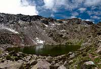
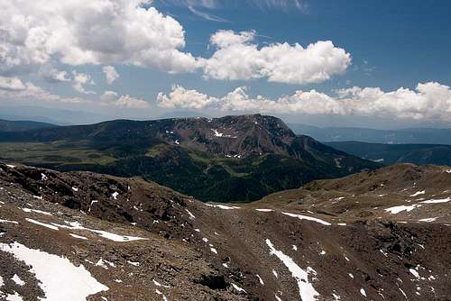
 The north face of Villanderer Berg / Monte Villandro The north face of Villanderer Berg / Monte Villandro |
The Sarntal Alps / Monti Sarentini are - in the true sense of the word - a much overlooked mountain range. With the main summits reaching heights of only 2700m - 2800m the range vanishes among its glaciated neighbours of the Stubai, Ötztal and Zillertal Alps in the north, the western Dolomites in the south-east and the Ortler Group in the south-west. The range is horseshoe shaped with the principal summits taking up the northern (closed) end of the horseshoe. However, there is one mountain outside this area which attracts attention wherever you go: Villanderer Berg / Monte Villandro.
While only 2509m in height, this mountain is located not far from the centre of the horseshoe and thus at the same time is an excellent and popular lookout peak and the central summit of the range. Its west face towers right above the town of Sarnthein / Sarentino, from where a long and strenuous route heads for the summit. Its north face, while smaller, is still very impressive but on the eastern and southern sides gentle slopes and pastures prevail. The mountain's name is taken from one of these pastures, Villanderer Alm / Malga Villandro, which has been used by the people of Villanders / Villandro for ages to graze their cattle. Though the town of Villanders is located far to the east of the mountain in Eisacktal / Valle d'Isarco, the pastures reach up from the valley floor to the eastern base of the mountain.
 |  |  |
Villanderer Berg / Monte Villandro is made up from porphyry and thus is a typical example for the mountains which surround the city of Bozen / Bolzano. There a huge (geologically speaking) slab of porphyry remains, upon which much of the younger mountain ranges (like the Dolomites) have piled up. Villanderer Berg / Monte Villandro is the northernmost exponent of this porphyry slab - further north the rock turns to a mixture of quartzite and schist, which makes for easy but horribly loose ascent routes. Here, at Villanderer Berg / Monte Villandro solid blocks of porphyry prevail.
The popularity of the mountain stems from its easy access across Villanderer Alm from the cable car at Rittner Horn / Corno Renon. Two routes lead to the summit, using either the south or east ridges of the mountain. The former one leads to Sarner Scharte, a saddle in the west face of Villanderer Berg / Monte Villandro from where an easy but lofty ridge traverse heads for the top. The latter starts on Villanderer Alm, where the east ridge of the mountain runs out. Again, the hike is easy but in some section a bit exposed. A third route joins the east ridge further on up the ridge, starting at Totenkirchl, a small Chapel underneath the north face of the mountain.
 |  |  |
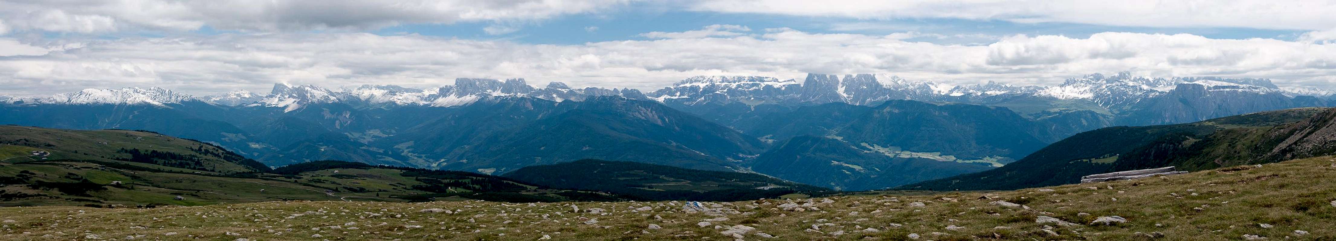
Thanks to its location inside the Sarntal Alps horseshoe Villanderer Berg / Monte Villandro is the best lookout peak for the mountains of the little range. However, in most cases views will be diverted eastward, where the wonderful structures of the western Dolomites can be seen across Eisacktal / Valle d'Isarco. And on fine days the glaciated peaks of the higher ranges mentioned above will glimmer.
Panoramic View
  |
Getting There
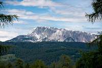
 Villanderer Berg seen from Karnspitz
The two most reasonable trailheads for Villanderer Berg / Monte Villandro are at Rittner Horn / Corno Renon already on top of the high plateau of the southern Sarntal Alps or at Sarnthein / Sarentino right in the range's midst. Both trailheads can be most easily reached from the city of Bozen / Bolzano, which itself can be reached by the Brenner motorway A22.
- For Rittner Horn / Corno Renon simply follow the signs Ritten / Renon from Bozen / Bolzano. They will lead you to Klobenstein / Collalbo, from where signs direct you to the cable-car at the base of Rittner Horn / Corno Renon. Either hike or take the cable-car to the top of Schwarzseespitze /Punta Lago Nero.
- For Sarnthein / Sarentino follow the signs to Sarntal / Val Sarentino from Bozen / Bolzano (SP508). Always remember that you'll have to ascent for more than 1500m to reach the top.
Red Tape
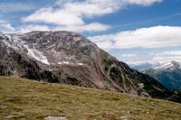
 Villanderer Berg above Anteransee
There's no red tape here. As usual in this area of the Alps the pastures are used for cattle grazing and thus fenced. Please close any gates you hike through.
Accommodation
 |
Eisacktal / Valle Isarco
Bozen / Bolzano
Weather Conditions
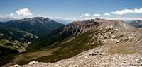
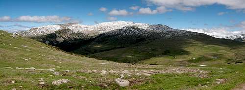 Villanderer Berg seen from Villanderer Alm
Maps & Books
Maps
- Digital Maps
- Regular Maps
- Sarntal/Val Sarentino
Kompass Map WK 056
1:35.000
ISBN: 3-85491-340-0
- Brixen / Bressanone
Kompass Map WK 56
1:50.000
ISBN: 3-85491-063-0
- Bozen / Bolzano
Kompass Map WK 54
1:50.000
ISBN: 3-85491-061-4
- BOLZANO-RENON / BOZEN-RITTEN-TSCHÖGGLBERG
Tabacco Map 034
1:25.000
- MONTE SARENTINI / SARNTALER ALPEN
Tabacco Map 040
1:25.000
- Sarntal/Val Sarentino
Books
- Bozen-Salten-Schlern
Kompass Guidebook WF953
Kompass Verlag
ISBN: 3-85491-406-7
- Rund um Bozen
Helmut Dumler
Rother Verlag
ISBN: 3-7633-4267-2