
|
|
Mountain/Rock |
|---|---|
|
|
43.13330°N / 19.00460°E |
|
|
Hiking, Mountaineering, Sport Climbing, Skiing |
|
|
Spring, Summer, Fall, Winter |
|
|
7851 ft / 2393 m |
|
|
Intro
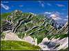
 South Durmitor Dreamscape
Main crest of Durmitor stretches in NW-SE direction. Although central Durmitor is not a large area and is very compact, main crest divides two quite different worlds. North of the main crest, which includes the highest peak Bobotov Kuk (2522m), is obviously north part of central Durmitor. Here rock, cliffs and large glacial basins are predominant feature while lower is belt of beech, spruce and fir forests. From the main crest several parallel crests stretch towards the north, perpendicularly to the main crest. Between them are glacial valleys. All the main peaks are part of these crests. South of the main crest story is quite different. Juicy green slopes and elegant sharp peaks prevail here. This is the area of huge undulating green pastures and greenery climbs all the way to the summits and is beautifully mixed with white limestone cliffs. Because whole area is high there isn’t a single tree to be seen. If you like green color this is the place that you’ll fall in love with. But grassy slopes aren’t just green. This is the carpet of millions of flowers and virtually all colors are represented when they bloom during the summer. Area also includes mightiest (Prutas) and most elegant (Stit, Sedlena Greda) peaks of Durmitor. All of this is gathered is south central Durmitor and this page is dedicated to it.
Area is on the opposite side of the massif from Zabljak town, a center of the region and gateway to Durmitor. What makes this part of Durmitor easily accessible is Zabljak – Virak – Trsa macadam road. Without it this would be distant and difficult area to visit.
More about Durmitor find on Bobotov Kuk and Durmitor pages.
Note: Lat/Lon given here is that of Prutas
 |  |  |  |  |
Prutas (2393m)
 Prutas spectacle
Although Prutas (read Prutash) occupies ‘only’ 9th spot on the list of highest peaks of Durmitor it certainly is one of the trademark peaks of the massif. Prutas is one of the most beautiful, most popular and certainly the largest of Durmitor peaks. It has four completely different sides, each one being very beautiful. From its summit one of the most beautiful Durmitor panoramas spread upon the probably most beautiful corner of Durmitor, Skrka valley. Prutas is full of superlatives and rightfully so. If you are visiting Durmitor don’t miss Prutas, one of three ‘a must visit’ peaks of the massif (the other two would be Bobotov Kuk and Medjed).
Prutas is placed in the western part of southern central Durmitor. It ascends high above its surroundings and dominates the area. On the N is Gruda (2302m), from which it is separated by Ilin Do (2230m) pass. Gruda and Prutas in way make southern end of the crest that makes western side of Susica river canyon (read Sushica). ~~> Over the Ilin Do pass western approach from Todorov Do leads.
On the NE is amazing Skrka valley (read Shkrka) with its two famous lakes; Veliko & Malo Skrcko Jezero (Big & Small Skrka Lake). More about it is in section below. Above the valley Prutas rises very steeply, some 700m. Side is made of layered cliffs with grassy terraces.
On the E very steep grassy slopes of Prutas descend into the Prutaski Do (2007m) basin, which is one ‘floor’ above the Skrka valley. Further towards east Prutaski Do falls with belt of cliffs into the eastern part of Skrka valley. ~~> Through the Prutaski Do and over the eastern side northern approach from the Skrka valley leads.
Towards SE Prutas sends a narrow and panoramic ridge which separates Skrka valley from the grassy terraces and plateau on the southern side of central Durmitor. Lowest point of the ridge is Skrcko Zdrijelo (2114m), a narrow pass (read (Shkrchko Zhdrijelo). SE of the pass is Stit (2248m) (read Shtit), probably most beautiful peak on Durmitor and bit distant neighbor of Prutas. ~~> Over the Skrcko Zdrijelo pass southern approach from Dobri Do leads.
S side of Prutas, which falls into the Govedji Do basin (around 2000m), is most dramatic. Here numerous layered plates, several hundred meters high and perpendicular, make very interesting south face.
On the other hand W side which rises steeply above Todorov Do basin (around 1850m) is the most beautiful. It contains beautiful parallel white limestone cliffs that extend from the foot to the summit, several hundred meters. These cliffs are called Prutovi which is plural of the word Prut which means a twig or branch, such as those of which baskets are made. Prutas got its name after them, a mountain made of twigs.
As said in intro section of this chapter Prutas is very popular peak and is approached by three marked paths: from Dobri Do (2:15h), from Todorov Do (1:30h) and from Skrka valley (2h). This doesn’t seam much but Prutas is quite remote peak of Durmitor, far from the Zabljak town, which is gateway to visit Durmitor. What made Prutas easily accessible is Zabljak – Virak – Trsa macadam road, which passes along the southern and western foot of Prutas. Dobri Do and Todorov Do trailheads are on the road and from Dobri Do also Skrka valley is only 2:30h away. But in winter, when road is not cleaned of snow, this becomes remotest and most difficult corner of Durmitor to access. In winter probably very few people reach the summit of Prutas.
 Prutas - giant of Durmitor
Panorama from the summit of Prutas is amazing! From here it is most beautiful view of Skrka Valley and highest peak of Durmitor, Bobotov Kuk, which rules on the other side of the valley, on the NE. Also very close is colorful Stit with its amazing twisted layers of limestone cliffs, on the E. On the N is Susica canyon and Ljubisnja mountain farther away. On the S are vast grassy plateaus and basins of Durmitor closed by elegant Sedlena Greda and picturesque ridges of Boljska Greda and Lojanik. Further away is Vojnik mountain and on clear days views spreads far south, ell the way to Orjen massif and the Adriatic coast. On the W are even larges grassy plateaus of Pivska Planina. Behind it is beautiful group of mountains led by Bioc and Maglic, highest peak of Bosnia & Herzegovina.
 |  |  |  |  |  |  |
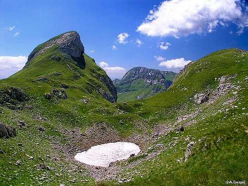
Skrka
 Skrka valley from Prutas
Skrka (read Shkrka) or Skrcka Dolina (The valley of Skrka, Skrka Valley) is wildest yet most romantic and with consensus among everybody the most beautiful corner of Durmitor. This amazing valley, whose undulating karst bottom harbors two beautiful lakes, is also surrounded by the most beautiful peaks of Durmitor. But no superlatives galore or photograph can prepare you for the first meeting with Skrka valley; it takes your breath away.
Skrka occupies SW corner of central Durmitor. Valley is around 2.5km long while bottom is up to 1km wide. Its upper edge or the peaks on the opposite sides of the valley are around 2km apart which means they rise very steeply above the valley.
From all but NW side, where opening of Susica canyon is (read Sushica), Skrka is closed by high and wild sides. And all three sides are different, having different color and character. On the N & E is main crest of the massif. Side is between 600 and 800m high. Lower few hundred meters are made of immense scree slopes while above are cliffs. Above northern part of the valley is broad Planinica (2330m) which means small mountain (Planinica is diminutive of Planina which means mountain). Planinica is not a real peak but actually the highest point of large glacial cirque Alisnica which suddenly, like cut off, falls into the Skrka valley. Planinica is highest point in the edge of Alisnica and edge continues towards SE till the foot of Bezimeni Vrh (2487m), which is the beginning of the real fortress that is E corner of Skrka valley. And in the corner are Bobotov Kuk (2522m) and Djevojka (2440m). With several hundred meters high limestone cliffs and immense scree slopes below they steeply fall into the Skrka valley.
In the SE corner of the valley is another attraction of Durmitor; Stit (2248m). With its twisted limestone layers of cliffs and green terraces it is most beautiful and colorful peak of Durmitor. These layers are called Sareni Pasovi (colorful layers).
S of the valley is large but calm and green basin of Prutaski Do, one ‘floor’ above the valley, and mighty Prutas (2393m), which rises with steep layered cliffs above the valley.
Neighboring Gruda (2302m), which is W of valley is wild like Prutas also.
Valley floor of Skrka is undulating. It is mix of meadows and stunted beech groves. Jewel of Skrka are its two lakes. Veliko Jezero (1686m) (Large Lake) and Malo Jezero (1711m) (Small Lake). Veliko Jezero (1686m) (Large Lake) is elongated and placed in the middle of the valley. It is 580m long and up to 165m wide, 17m deep and has 1720m long coastline. Part of the coast is under stunted beech trees. Malo Jezero (1711m) (Small Lake) is rounded and placed below the cliffs of mighty Prutas (2393m). It is 225m long and up to 94m wide, 15m deep and has 440m long coastline. Between the lakes is grassy plateau on which mountaineering hut stands.
In the last Ice Age basin of Skrka was heavily glaciated and glacier was moving towards the canyon of Susica on the NW. Beginning of the Susica canyon is few hundred meters below the edge of Skrka valley, under the steep face. Skakala waterfall decorates the face during stronger waters, which comes underground from Veliko Jezero.
Skrka valley is not easily accessible as it is surrounded by mighty peaks. Access is possible from 5 directions. Easiest is southern approach which leads from Dobri Do (1700m), on the Zabljak – Virak – Trsa macadam road, over the Skrcko Zdrijelo pass (2114m). It lasts 2:30h. Western approach leads from Todorov Do (1850m), also on the Zabljak – Virak – Trsa macadam road, over the Ilin Do pass (2230m) and lasts also 2:30h. Northern approach leads through the canyon of Susica, from the mountaineering hut which is accessible by car from Zabljak via Stuoc and Crna Gora village. It lasts between 2:30-3h. Two eastern approaches from Zabljak are longest and toughest. The one via Alisnica and Planinica lasts 5h while the one via Bobotov Kuk and Zeleni Vir is even tougher because it includes a major drop to Zeleni Vir lake. This approach lasts around 7h.
In winter Skrka is very difficult to approach. Closest approaches from the Zabljak – Virak – Trsa road are unreachable because road is not cleaned of snow while eastern approach from Zabljak is very long. Skrka is then reserved for toughest of mountaineers. Return is not possible in a day and it is best to use tour skis.
 |  |  |
Stit (2248m)
 Stit (2248m) and its Zeleni Pasovi (Green Layers)
22nd on the highest peaks list but who cares, Stit (read Shtit) is the first on the Durmitor beauty list! Durmitor has many beautiful peaks but not one come close to this colorful fortress of sharp edges and its unrepeatable twisted limestone layers. Although Stit is very attractive peak this is one of those rare cases when peak is more interesting to be looked at than to be climbed.
Location of the Stit is very interesting among the peaks of southern central Durmitor. It is in the center of the area and visible from all angels. It enriches the panorama of every peak in the area. Stit makes most of the barrier which separates glacial basins of Skrka valley, which is on the NW, and Mlijecni Do on the SE. On the sides above these two valleys Stit has those famous twisted layers. Above Skrka valley they are called Sareni Pasovi (Colorful Layers) because between white limestone layers are green grass terraces with darker dwarf pines. On the other side, above Mlijecni Do, they are called Zeleni Pasovi (Green layers) because here there are no dwarf pine to add extra color but just limestone layers and green terraces.
On the NE is main crest of Durmitor. Stit, whose crest stretches in SW-NE direction, is perpendicular on the main crest, which stretches in NW-SE direction. With deep and most beautiful pass on Durmitor, Samar (2075m), Stit is separated from Djevojka (2440m), which is bit pushed outside of main crest towards Stit. Views from the narrow pass Samar, which is squeezed between the twisted layers of Djevojka and Stit, and the atmosphere of the whole place is breathtaking.
On the S Stit falls with steep cliffs into the Urdeni Do basin, a southern extension of Mlijecni Do, and towards the Dusko Valje grassy plateau.
Stit has two summits on the opposite ends of its body. Southern peak is 2236m high while the northern one has 2248m. Between them is narrow crest. Peak is very steep from all sides, mostly made of cliffs. But on the SE side above Mlijecni Do there is larger green slope between the summit crest and the area of cliffs below.
Stit isn’t marked. But there is a path which leads over the eastern side to the summit. It begins on the threshold where Mlijecni Do suddenly falls into over hundred meters lower Urdeni Do. Path ascends towards the north up the steep scree slopes and then turns left and finds a passage through the only weak spot in the cliffs of Stit and reaches mentioned large grassy slope. From there reaching the summit is easy. From the threshold it takes around an hour to the summit.
View from the summit is exceptional as all around you are various beauties of southern central Durmitor. Bobotov Kuk is almost at hands reach, Skrka valley is on your palm but one thing is missing in panorama; the colorful peak on which you are standing.
 |  |  |  |  |
Vjetrena Brda (2222m) & Uvita Greda (2199m)
 Uvita Greda
SE of Urdeni Do (around 1700m) and Mlijecni Do (around 1900m) basins group of peaks begins to stretch towards SE. It ends after 2.5km above the Sedlo Pass (1907m). This group of peaks is separate broad crest, parallel with the main crest of Durmitor, which is on the NE and from it separated by Surutka (2082m) and Valoviti Do (2091m), former glacial cirques, now depressions of which Surutka is grassy while Valoviti Do is rocky. This peaks are Vjetrena Brda (2222m) (Windy Peaks) and Uvita Greda (2199m). On the SW crest falls like a massive barrier of cliffs and scree towards the Dobri Do (1600m), a huge undulating grassy plateau.
Uvita Greda (2199m), which is on the SE, above Sedlo Pass, is most attractive peak in this subgroup. When approaching from Zabljak via Virak – Trsa road is looks like elegant and sharp peak while from Sedlo pass it shows its broad SW face.
Although group look predominantly grassy and gentle it is heavily karstified and contains many funnel shaped depressions and holes. Among best know is Jama na Vjetrenim Brdima (Hole on the Windy Peaks), which is with 897m deepest in Serbia & Monte Negro! It has been found in 1985. Entrance is on the altitude of 2196m.
Group is unmarked and not particularly interesting to mountaineers but popular among speleologists. Closest to marks is Uvita Greda. Under its SW face and over the pass which separates it from Vjetrena Brda Sedlo – Bobotov Kuk route passes. From the pass it is 10mins to the summit from which is beautiful view of Poscenska Dolina valley and neighboring Sedlena Greda (2227m).
Sedlena Greda (2227m)
 Sedlena Greda from Poscenska Dolina
Among the peaks of Durmitor which are south of Zabljak – Virak – Trsa road Sedlena Greda (2227m) has no match; both in beauty and height. It is placed S of Sedlo Pass (1907m). But between it and Sedlo Pass there is another very attractive peak, bit lower but very sharp; Zupci (2148m). Then, south of Zupci, Sedlena Greda rises. They are separated by nice green Sedleni Do, a wide saddle. Crest of Sedlena Greda stretches in NW-SE direction, like the main ridge. It is razor sharp with very steep sides. NE side falls over into Poscenska Dolina valley (read Poshchenska) while SW side falls into the valley between it and Boljska Greda (2091m). Both valley floors are at around 1700m so both sides of Sedlena Greda are over 500m high. On the NW Sedlena Greda ends like cut off above the Dobri Do, a huge undulating grassy basin (between 1600-1700m). On the SE, after the summit of Sedlena Greda, crest falls steeply towards the deep pass which separates it from the neighboring Ranisava (2084m).
Sedlena Greda is one of the most elegant peaks of Durmitor. This is especially true when observed from Dobri Do basin from where Sedlena Greda and its neighbor Zupci are two sharpest peaks on Durmitor. Its sides are mix of grass, scree and cliffs.
Sedlo means pass while greda means rafter, like those used in house construction. So Sedlena Greda would mean The Rafter of the Pass or The Rafter above the Pass (Pass being Sedlo road pass). Association of rafter comes from the narrow crest of Sedlena Greda.
Marks reached the summit of Sedlena Greda from the Sedlo Pass. Ascent lasts 1:30h and offers beautiful panoramas. View from the summit is wide and very beautiful. During the wet weather steep sides of Sedlena Greda are very slippery and dangerous.
 |  |  |  |
Lojanik (2091m) & Boljska Greda (2091m)
Lojanik and Boljska Greda make the southernmost edge of central Durmitor. This crest, which stretches in NW-SE direction like the main crest, is split up in two parts with the opening of Komarnica river canyon/valley. Both parts are equally high. Lojanik (2091m) makes the NW part while Boljska Greda (2091m) makes the SE. It is interesting that this crest looks completely different from the surroundings. Soft green carpet of Dobri Do undulating basin is suddenly replaced, like cut off, by shiny white limestone, in form of cliffs or scree, which is party overgrown by the most dense colonies of dwarf pine in southern part of Durmitor. Both sides of Lojanik rise above the green plateaus while Boljska Greda is bit different. Its NE side descends into the valley between it and Sedlena Greda (2227m). The real story here is SW side which falls deep into the canyon/valley of Komarnica river. Upper part of this side is long SW face, which is up to 700m high! This is highest face on Durmitor.Because of very difficult and heavily karstified terrain both Lojanik and Boljska Greda aren’t popular and are not marked. If you want to climb them you’ll have to find a way yourself. Closest and easiest approaches lead from Dobri Do pasture/basin.
 |  |
Dobri Do
 Dobri Do
In a way Dobri Do is the heart of southern central Durmitor. This beautiful high undulating basin is fantastic place where one could easily lie down in grass and enjoy 360° of amazing panorama which includes all the main peaks of south central Durmitor, including the main crest with main peaks, which are led by Bobotov Kuk (2522m). Peaks are very diverse from bulky and green slopes of Vjetrena Brda to massive Prutas with bare and powerful main crest behind. In panorama is also very sharp Zupci and Sedlena Greda to heavily karstified Lojanik and Boljska Greda. It is said that Dobri Do (Good/Nice Basin) is one of top three pasture areas in whole Monte Negro. We can only imagine how it used to be here when thousands of sheep and cows grazed on the undulating meadows. But even today there is quite allot of cattle here and lot of Katun’s. Katun is a word here for the small shepherd’s house. In the southern part of Dobri do is Sopot, a source of Komarnica, which at the southern edge of Dobri Do enters it beautiful canyon/valley.
 |  |
Routes Overview
Prutas (2393m)~ southern approach from the Zabljak – Virak – Trsa macadam road, from the edge of Dobri Do: 2:15h
~ western approach from the Zabljak – Virak – Trsa macadam road, from Todorov Do: 1:30h
~ northern approach from the Skrka valley: 2h
Skrka valley
~ southern approach from the Zabljak – Virak – Trsa macadam road, from the edge of Dobri Do: 2:30h
~ western approach from the Zabljak – Virak – Trsa macadam road, from Todorov Do: 2:30h
~ northern approach from the Susica canyon: 2:30-3h
~ eastern approach from Zabljak via Alisnica & Planinica: 5h
~ eastern approach from Zabljak via Bobotov Kuk & Zeleni Vir: 7h
Stit (2248m)
~ eastern approach from Mlijecni Do (unmarked): 1h
Uvita Greda (2199m)
~ southern approach from Sedlo road pass (1907m) (mostly marked): 45min
Sedlena Greda (2227m)
~ northern approach from Sedlo road pass (1907m): 1:30h
Getting There
Gateway to Durmitor is Zabljak town. Here is information how to get there.By Plane
Air gateway to Monte Negro is capital Podgorica. Information about flights find on the sites of Serbian JAT Airways, a former Yugoslav airlines, or on Montenegrin Montenegro Airlines. Once in Podgorica by plane you’ll have to take a bus or rent a car.
By Bus
Buses go to Zabljak from Podgorica, Niksic, Pljevlja and Mojkovac several times per day.
By Car
Niksic – Savnik (47km) – Zabljak (37km): 84km –> before tunnel on Vojnik mountain was opened this was normal Niksic to Zabljak approach from south. It is beautiful but hard to drive mountain approach as road is slow and narrow with two major ascents. First it ascends from Niksic (649m) to Krnovo pass (1487m). Behind is steep descent to Savnik (824m) town and then long ascent via bad and narrow road to Zabljak (1450m).
Niksic – Savnik (35km) – Zabljak (37km): 72km -> since road and tunnel on Vojnik mountain, which connects Niksic – Piva river road with Savnik town, was opened this is normal Savnik and Zabljak approach from Niksic (649m) as one avoids Krnovo pass. Head towards Piva River. 17km’s behind Niksic, at Jasenovo Polje, turn right towards Savnik. Road ascends up the Vojnik mountain till 1500m where is short tunnel below the main crest. Behind is steep descent to Savnik (824m). From Savnik bad and narrow mountain road leads to Zabljak.
Podgorica – Niksic: 55km –> Add this length if you are going to Zabljak from Podgorica via Niksic. Road to Niksic from Podgorica is good.
Podgorica – Kolasin (71km) – Mojkovac (21km) – Zabljak (67km): 159km -> road is good all the way to Zabljak. Behind Podgorica (56m) you gradually go inside Moraca River canyon which gradually turns ever more spectacular. Canyon of Moraca is one of spectacular Montenegrin canyons. It is up to 1000m deep and has wild sides. After exiting the canyon there is short section of wider valley, by the road is famous Moraca monastery. Soon long and steep ascent over Crkvine pass (1045m) begins. From it is amazing view towards beautiful and wild surrounding mountains and from top into the Moraca River valley. Behind Crkvine pass there is short descent to Kolasin town. By the Tara River road continues to Mojkovac town. Till here you are on main Montenegrin road which connects Podgorica with Serbia so expect traffic, especially during summer. From Mojkovac you leave the main road by going left towards Zabljak. Road follows Tara River and after some 12km through wide valley Tara enters its spectacular canyon which is 1000m deep on this section. After 32km you are at legendary bridge on Djurdjevica Tara. From the bridge road ascends in many bends out of Tara’s canyon and after 23km you are in Zabljak. Once on Jezerska Povrs plateau peaks of Durmitor enter the view, they act magnetically. This is amazing drive all the way.
Maps
On Zabljak you can buy very good maps of Durmitor (1:25000 scales) in almost every store.

When to Climb
Durmitor is typical summer hiking mountain. From October to June it is under snow whose depth grows towards spring to few meters. Then very few visit central part of Durmitor. Of course, as any mountain Durmitor can be climbed during whole year including mid winter, but in Monte Negro such activity is not yet well developed so it is quite unlike that you will meet someone, except at the edge of central part where people ski. Full winter equipment is necessary; don’t need to say what that includes. Temps can drop to -30°C! Large open slopes of central part, which are under deep snow that covers even large boulders making them smooth, must be paradise for extreme and tour skiers in amazing scenery. During short summer temperatures are pleasant which means it is not hot to die and it is not that cold to be in long sleeves and trousers. Anyway as soon as clouds cover the Sun and there is little bit of wind warm clothes is necessary so always have a jacket in backpack. Snow is possible even in mid summer.Area of Durmitor that this page covers is hardly accessible in winter because Zabljak – Virak – Trsa road is not cleaned of snow. As far as you can get with it is Savin Kuk ski center. From there you can reach the Sedle pass with tour skis. On foot it could be little bit too far.
Mountain Conditions
Weather forecast and conditions can be found for Zabljak at Accuweather site.On WeatherOnline there is no Zabljak but you can find forecast for various Monte Negro towns. Of them Pljevlja is closest to Zabljak (some 30km to the north).