
|
|
Mountain/Rock |
|---|---|
|
|
43.10000°N / 19.00000°E |
|
|
7877 ft / 2401 m |
|
|
Overview
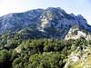
 Velika Rbatina (2401 m) SE face from Biljegov Do rocky basin
DURMITOR massif have 48 peaks above 2000 m and 27 peaks above 2200 m. One of them is Velika Rbatina (2401 m), 7th highest peak of Durmitor. It's high and large massif dominate above central part of Durmitor massif. Looking from Zabljak (1456 m) town you can easily see powerful crest of Velika Rbatina peak. Velika Rbatina NW face looks to Gornja Alisnica (2091 m) valley, while it's SE face dominate above Biljegov Do rocky basin. From both sides, Velika Rbatina (2401 m) massif looks spectacular.
Velika Rbatina invite everyone who like impressive mountain summit panoramas, specially views to highest peaks of massif. Velika Rbatina summit can be reached during whole year, but the best time is mid July - mid September. Also, before and after that period you can climb Velika Rbatina, also on the snow in winter&spring time.
Velika Rbatina (2401 m) summit is one of most spectacular viewpoint to highest peaks of Durmitor - Bobotov Kuk (2523 m) and Bezimeni Vrh (2487 m) N faces, which proudly and very impressive dominates above the rocky sea of Valoviti Do rocky basin. Also, from Velika Rbatina summit you can enjoy in privilege to watch NW face of Minin Bogaz (2387 m), "alpine needle" of Durmitor massif.
 Rbatina from Bezimeni Vrh
LOCATION:
Velika Rbatina (2401 m) peak is placed in the heart of highest peaks of Durmitor massif. It's beautiful peak is surrounded by impressive and elegant forms of many peaks like Bobotov Kuk (2523 m), Bezimeni Vrh (2487 m), Minin Bogaz (2387 m) and Obla Glava (2303 m). On the S, Velika Rbatina is separate from Bezimeni Vrh (2487 m) by high rocky pass Velika Struga (2274 m), from where you can reach Velika Rbatina (2401 m) summit and also Bezimeni Vrh (2487 m) summit.
Velika Rbatina massif is situated on the W from Savin Kuk (2313 m), Medjed and Cvorov Bogaz (2152 m), on the N from Bobotov Kuk (2523 m), Bezimeni Vrh (2487 m), Djevojka (2440 m), Prutas (2393 m) and Stit (Sareni Pasovi, 2248 m), on the NW from Sljeme (2455 m), Milosev Tok (2426 m), Bandijerna (2409 m), Minin Bogaz (2387 m), Zupci (2309 m) and Terzin Bogaz (2303 m), on the E from Planinica (2330 m), Susica Canyon and Skrka Valley, on the S from Obla Glava (2303 m), Stuoc (2200 m), Gologlav (2196 m), Pasina Gomila (2196 m) and Crvena Greda (2175 m).
 North side of Velika Rbatina, zoom from Crvena Greda
SUMMIT VIEW:
E: Savin Kuk (2313 m), Medjed, Cvorov Bogaz (2152 m)
W: Planinica (2330 m), Mt Bioc (2397 m), Mt Maglic (2388 m), Mt Volujak (2336 m)
N: Obla Glava (2303 m), Stuoc (2200 m), Crvena Greda (2175 m)
S: Bobotov Kuk (2523 m), Bezimeni Vrh (2487 m), Prutas (2393 m), Skrka Lakes Valley (1686 m)
SE: Sljeme (2455 m), Milosev Tok (2426 m), Bandijerna (2409 m), Minin Bogaz (2387 m), Zupci (2309 m), Terzin Bogaz (2303 m)
 Velika Rbatina from Velika Struga pass
 |  |  |
Routes Overview
 Rbatina from Minin Bogaz
Exist 4 approach to reach summit of Velika Rbatina (2401 m). All these routes are different and spectacular, because you going through different valleys and parts of Durmitor massif.
1. Ledena Pecina (Ice Cave, 2217 m) approach: Crno Jezero (Black Lake, 1416 m) - Jaksica Mlin (1514 m) - Biljegov Do (1965 m) - Valoviti Do (2037 m) - Velika Struga (2274 m) pass - Velika Rbatina (2401 m): 4 h
2. Alisnica Valley approach: Crno Jezero (1416 m) - Jaksica Mlin (1514 m) - Crapulj Poljana (1716 m) - Alisnica Valley (2091 m) - Velika Struga (2274 m) pass - Velika Rbatina (2401 m): 4.15 h
3. Lokvice Valley approach: Crno Jezero (1416 m) - Jaksica Mlin (1514 m) - Lokvice Valley (1693 m) - Biljegov Do (1965 m) - Valoviti Do (2037 m) - Velika Struga (2274 m) pass - Velika Rbatina (2401 m): 4.15 h
4. Skrka Valley approach: Skrka Hut (1723 m) - Planinica summit (2330 m) - Gornja Alisnica (2091 m) - Velika Struga (2274 m) pass - Velika Rbatina (2401 m): 3 h
Important: Part of the path of Alisnica Valley approach - Gornja Alisnica Valley (2091 m) - Velika Struga (2274 m) pass is unmarked. Also, part of the path Velika Struga (2274 m) pass - Velika Rbatina (2401 m) is also unmarked.
 Velika Rbatina above Valoviti Do basin
 Velika Rbatina from Veliki Medjed
 |  |  |
Getting There
Gateway to Durmitor National Park and Velika Rbatina (2401 m) peak is Žabljak (1456 m) town. Information how to get there:By Plane
~To Beograd (Belgrade, Serbia&Montenegro capital) airport. Than with plane to Podgorica, capital of Montenegro, or with bus or car to Zabljak town.
~To Podgorica airport. Than with bus or car to Zabljak town.
Information about flights find on the sites of JAT Airways, a former Yugoslav airlines, or on Montenegro Airlines.
By Bus
~Beograd (Belgrade)-Zabljak
~Podgorica-Zabljak
~Niksic-Zabljak
~Pljevlja-Zabljak
Buses go to Zabljak from Beograd (Belgrade) twice a day and from Podgorica, Niksic, Pljevlja and Mojkovac several times per day.
By Car
~Beograd (Belgrade)-Zlatibor-Nova Varos-Prijepolje-Pljevlja-Zabljak
~Niksic - Savnik (47km) - Zabljak (37km): 84km; Niksic to Zabljak approach from south.
~Niksic - Savnik (35km) - Zabljak (37km): 72km;
~Podgorica - Niksic (55 km)-Savnik (47 km)-Zabljak (37 km): 139 km; Add this length if you are going to Zabljak from Podgorica via Niksic. Road to Niksic from Podgorica is good.
~Podgorica - Kolasin (71km) - Mojkovac (21km) - Zabljak (67km): 159km; road is good all the way to Zabljak. Behind Podgorica (56m) you go inside Moraca River canyon (one of spectacular Montenegrin canyons). It is up to 1000m deep and has wild sides. That's spectacular drive. After that, from "Djurdjevica Tara" bridge to Zabljak - 23 km.
 |  |
When To Climb
 N side of Velika Rbatina
Velika Rbatina (2401 m) peak in Mt Durmitor you can climb during all year seasons, but ideal period for climbing is mid June - mid September. But, you can also climb with crampons and other equipment during winter-spring period. Rbatina is very attractive peak for climbing in this period.
During the winter, Durmitor usually switches into ski resort. Under Savin Kuk peak (2313 m) is Durmitor Ski Center. (gondolas, ski lifts, chair lifts, restorants and their customers).
Crno Jezero (Black Lake, 1416 m) and Ivan Do Camp locations are a common climbing starting points for reaching of Velika Rbatina (2401 m) summit. All major trails further uphill are well marked with white circle/red border marks.
Whole Durmitor mountain is very good marked. Thanks to Branislav Cerovic, greatest knower and devoter of Durmitor National Park, who marked all routes on Durmitor mountain.
 |  |
Camping
 Minin Bogaz, Obla Glava and Velika Rbatina from Štuoc
Camping permitted on camping dedicated spots only.
Generally, in Durmitor, major huts are in good condition, but with no service. Still, open to the general public. Just in mountain Skrka Hut in Skrka Valley and Susica Hut in Susica Canyon you can buy the food, but not cooking meal. There you can sleep on beds with blankets. In other huts, hikers/climbers are supposed to bring all the jummy stuff with them.
On Durmitor exist camps in Ivan Do and Razvrsje, and few mountain huts and bivouacs:
~Hut with few small shepherd's houses in Lokvice valley
~Hut in Skrka Lakes valley (you can sleep and buy the food)
~Bivouac in Velika Kalica valley
~Hut "Mushova koliba" (Stari Katun) on the road from Zabljak to Obla Glava (2303 m) peak, near Ledena Pechina (Ice Cave) - empty simply hut from wood, without service, simple conditions...
~In Ivan Do camp price for camping is 4 Euro per day.
Also, in Zabljak town you can rent private room or apartment. Price for 2-beds apartment with kitchen and bathroom: 10-12 Euro (5-6 Euro per person).
In some villages on mountain, for example in Bosaca village, you can rent a 2-beds apartment for price 6-8 Euro (3-4 Euro per person) with free milk products every day (1 liter of caw milk).
 |  |
Mountain Conditions
The best weather forecast on Internet for Durmitor (Zabljak town) is VREME YUBC NET site. You can see 5 days forecast for Durmitor area, 4-times-daily forecast. |  |
Maps
Exist three maps of Durmitor:1. Map of Durmitor Massif & Tara Canyon - 1:25000. Author: Branislav Cerovic. You can buy it in Zabljak town in almost every store. Price: 5-6 euro.
2. Map of Durmitor National Park & Tara Canyon - 1:25000. Author: Branislav Cerovic. You can buy it in Beograd (Belgrade, Serbia) in Geokarta Co, Belgrade. Price: 2 euro. This map is better than first one and include many informations and facts about routes, peaks, lakes, glacial cirques, valleys, canyons,...
3. Durmitor Mountain Guide & Map. Short mountain guide with some basic informations and facts. Author of map: Pavle S. Bandovic. Editor: "Summit" Travel Agency, Zabljak, 2005. Price of Guide&Map: 7 euro.
 |  |
Red Tape
No fees or extra fees for entering the National Park.No permits needed either.
Usual rules of behaviour for NP's do apply.
 |  |