
|
|
Mountain/Rock |
|---|---|
|
|
43.10000°N / 19.00000°E |
|
|
7644 ft / 2330 m |
|
|
Overview
Planinica (2330 m) summit view to Bezimeni Vrh (2487 m), Bobotov Kuk (2523 m) and Djevojka (2440 m)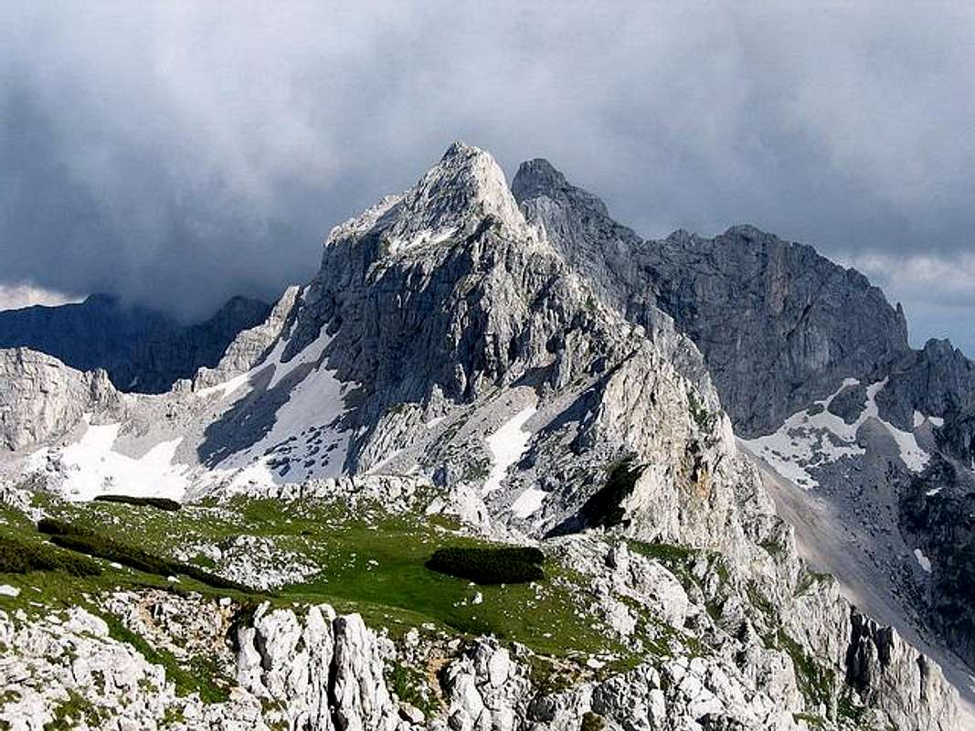
Planinica (2330 m) peak is becoming more and more fashionable as a first-class viewpoint of DURMITOR's amazing and incredible beauty and it's untouchable nature.
Planinica (2330m) which means small mountain (Planinica is diminutive of Planina which means mountain), is not a real rocky peak (as Bobotov Kuk - 2523 m, for example), but actually the highest point of large glacial cirque Alisnica which falls into the beautiful Skrka valley. Skrcka Lakes Valley is surrounded by the most beautiful peaks of Durmitor. Skrka occupies SW corner of central Durmitor. Valley is around 2.5 km long while bottom is up to 1km wide. Its upper edge or the peaks on the opposite sides of the valley are around 2 km apart which means they rise very steeply above the valley.
Whole Planinica climbing trip is some kind of extraordinary journey, during which you can see many different expression of beautiful Durmitor's nature. When i was climbing Planinica summit with my friends, two of them after that told me that scenery of Gornja Alisnica valley remaind them to "The Lord of The Rings" movie and it's beautifully panoramas. That's no so far from the truth.
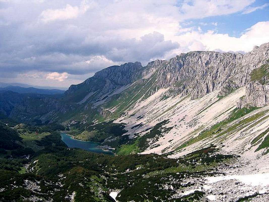
On Durmitor exist two extraordinary peaks, on which grassy summits you can really enjoy whole day in unforgetable panoramas of incredible beauty of Durmitor and it's most beautiful corner called Skrcka Lakes valley, surrounded by the most beautiful peaks of Durmitor massif. One is Prutas (2393 m) and the second one is Planinica (2330 m). Planinica staying oposite to Prutas peak, above incredible diamond of Durmitor - amazing Skrcka Lakes valley with two beautifully lakes, Veliko Jezero (Large Lake, 1686 m) and Malo Jezero (Small Lake, 1711 m).
Planinica (2330 m) massif above Dolina Skrckih Jezera (Skrka Lakes Valley)
From Zabljak town (Crno Jezero, where is usual start point) to Planinica summit, you will spend about 4 h of walking. First, you will go inside of deep and nice forest, where you'll meet non activ white water-mill. Here is placed the mountain guidepost. You must follow caption Alisnica-Planinica. This route go away (near) from Zminje Jezero (Snake's Lake). When you will come out from this forest, you will see beautiful grassy field called Poljanak with awesome green grass, below of powerful crest of Crvena Greda (2164 m) on the right.
Way continues inside of another forest and when you will come out, you'll see wonderful Crapulj Poljana (1716 m) grassy field with few old shepherd's huts. Nice place for short rest. Route goes than to Donja Alisnica (1940 m) valley and after that to Gornja Alisnica (2091 m) valley. This two connected valleys are real paradise for enjoyment and resting inside of extraordinary untouchable nature. Specially, Gornja Alisnica valley is an inredible beauty.
Route than continues to Gornje Lokve grassy plateau, where you can see during Summer beautiful horses, who living there during Summer time. Their owners coming 1 time per week, to bring them salt (necessary minerals). Horses also drinking water from the lokve (small pools) and graze the grass.
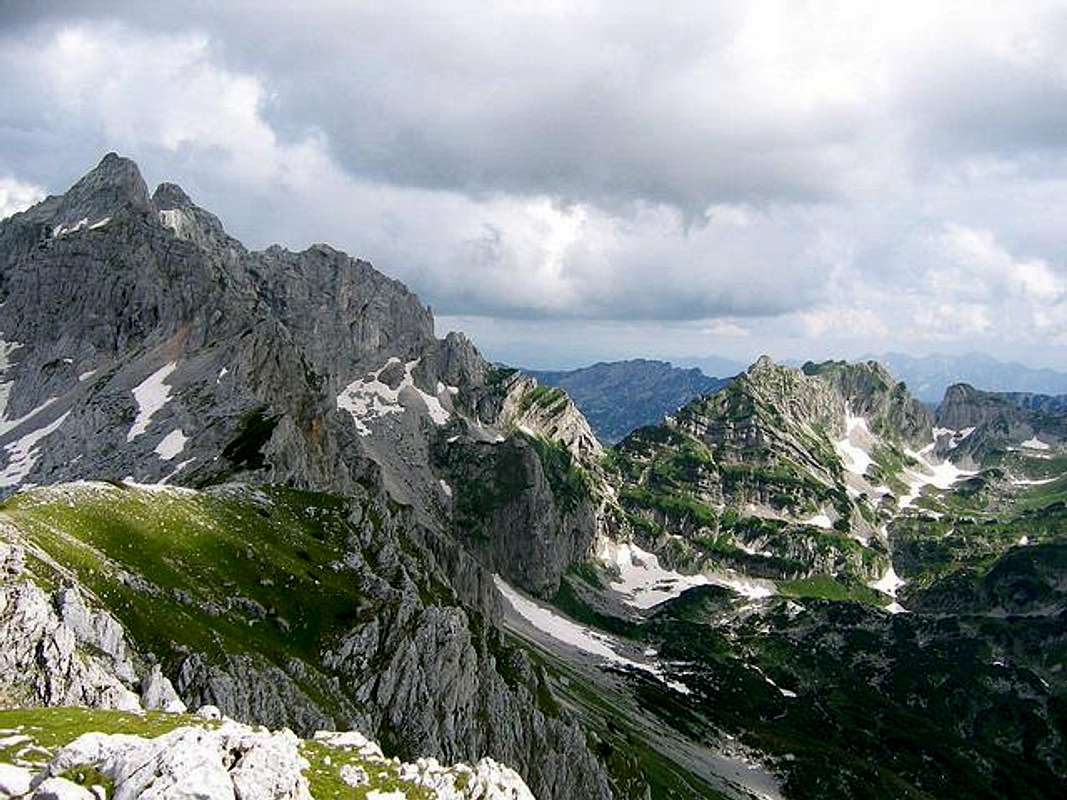
Peaks of DURMITOR massif from Planinica (2330 m) summit
Many beautifully horses, in many different colors, staying, runing and jumping on beaufitul grass of Gornja Alisnica valley are scenery, which i from the heart recommended to anyone to must to see. Really, unforgetable. Route than goes to Medjedje Zdrijelo (2251 m) pass, from where you can after some minutes reach the Planinica summit (2330 m). And then - incredible scenery and panorama!
From Planinica summit you can see incredible and amazing beauty of most wonderful corner of Durmitor massif. On the left you can see famous wall called "Soa Nebeska" which contain three peaks - Bezimeni Vrh (2487 m), Bobotov Kuk (2523 m) and Djevojka or Soa (2440 m). Also, on the left you can see nice Samar saddle pass (2075 m) and beautiful trademark of Durmitor - Sareni Pasovi or Stit peak (Colourful Layers, 2245 m) with all it's amazing beauty.
In front of Planinica summit you can enjoy in impressive Prutas (2393 m) peak. On the right you can see nice Susica canyon. Below Planinica summit, you will have a chance to enjoy in breathtaking view to famous Skrcka Lakes valley with it's two beautifully glacial lakes Big and Small Skrcka lakes - "Mountain Eyes" of Durmitor.
Far, in background you can see Sinjajevina (2253 m), Kapa Moracka (2226 m), Bioc (2397 m), Vlasulja (2337 m) and Maglic (2387 m) mountains, and beautifully Piva and Komarnica canyons.
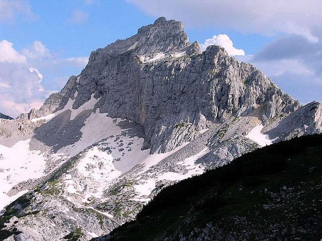
Bezimeni Vrh (2487 m) from Alisnica Valley, during Planinica (2330 m) summit climbing
Wonderful grassy Planinica summit and enjoyment on it you will never forget. You can spend whole day for relaxation with your family or with your friends and enjoy in many beautiful views and landscapes of Durmitor peaks, valleys, passes, canyons and lakes.
Like "point on I" you can descent to Skrcka Lakes valley and enjoy in it's extraordinary beauty. 1 h of walking is time for this descent. In Skrka valley exist mountain hut and you can stay inside, but first (before Planinica climbing) check in Zabljak touristic office, is the hut active or not.
 |  |  |  |  |
Getting There
Prutas (2393 m) and Skrcka Jezera (Skrka Lakes) from Planinica (2330 m) summit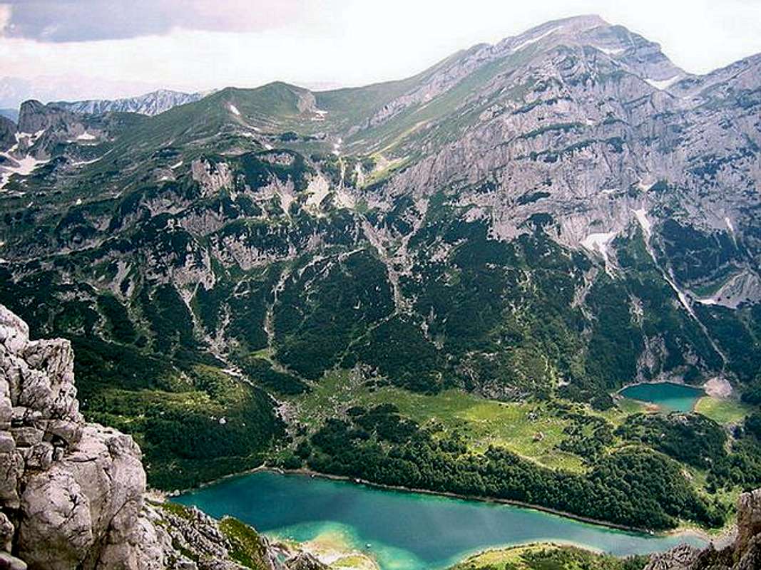
Gateway to climbing Planinica (2330 m) peak in DURMITOR massif is Zabljak town. Information how to get there:
By Plane
~To Beograd (Belgrade, Serbia&Montenegro capital) airport. Than with plane to Podgorica, capital of Montenegro, or with bus or car to Zabljak town.
~To Podgorica airport. Than with bus or car to Zabljak town.
Information about flights find on the sites of JAT Airways, a former Yugoslav airlines, or on Montenegro Airlines.
By Bus
~Beograd (Belgrade)-Zabljak
~Podgorica-Zabljak
~Niksic-Zabljak
~Pljevlja-Zabljak
Buses go to Zabljak from Beograd (Belgrade) twice a day and from Podgorica, Niksic, Pljevlja and Mojkovac several times per day.
By Car
~Beograd (Belgrade)-Zlatibor-Nova Varos-Prijepolje-Pljevlja-Zabljak
~Niksic - Savnik (47km) - Zabljak (37km): 84km; Niksic to Zabljak approach from south.
~Niksic - Savnik (35km) - Zabljak (37km): 72km;
~Podgorica - Niksic (55 km)-Savnik (47 km)-Zabljak (37 km): 139 km; Add this length if you are going to Zabljak from Podgorica via Niksic. Road to Niksic from Podgorica is good.
~Podgorica - Kolasin (71km) - Mojkovac (21km) - Zabljak (67km): 159km; road is good all the way to Zabljak. Behind Podgorica (56m) you go inside Moraca River canyon (one of spectacular Montenegrin canyons). It is up to 1000m deep and has wild sides. That's spectacular drive. After that, from "Djurdjevica Tara" bridge to Zabljak - 23 km.
 |  |  |
Routes Overview
Veliko&Malo Skrcko Jezero (Large&Small Skrka Lake) from Planinica (2393 m) summit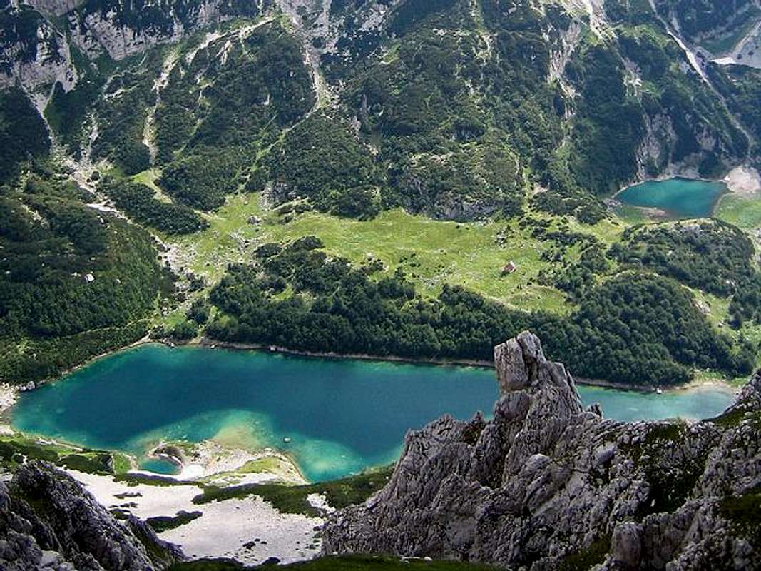
PLANINICA (2330 m):
~Usual route: Zabljak (1450 m) - Ivan Do (1470 m) - Jaksica Mlin - Zminje Jezero (1520 m) - Crapulj Poljana (1716 m) - Donja Alisnica valley (1940 m) - Gornja Alisnica valley (2091 m) - Medjedje Zdrijelo (2251 m) - Planinica (2330 m). Climbing time: 4 h. Height difference: 900 m.
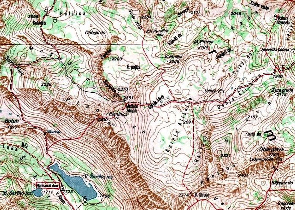
Map of Planinica (2330 m) area and it's surroundings
~Skrka - Planinica ascent route: Skrcka Lakes valley (1686 m) - Planinica (2330 m). Climbing time: 3 h. Difficult ascent on very stepp rocky side of Planinica.
~Planinica - Skrka descent route: Planinica summit (2330) - Skcka Lakes valley (1686 m). Climbing time: 2 h
 |  |  |  |  |
When To Climb
You can climb during all year seasons, but ideal period for climbing is mid June - mid September.During the winter, Durmitor usually switches into ski resort. Under Savin Kuk peak (2313 m) is Durmitor Ski Center. (gondolas, ski lifts, chair lifts, restorants and their customers).
Crno Jezero (Black Lake) location is a common climbing starting point. All major trails further uphill are well marked with white circle/red border marks.
Whole Durmitor mountain is very good marked. Thanks to Branislav Cerovic, greatest knower and devoter of Durmitor National Park, who marked all routes on Durmitor mountain.
 |  |  |
Camping
Camping permitted on camping dedicated spots only.Major huts are in good condition, but with no service. Still, open to the general public. Hikers/climbers are supposed to bring all the jummy stuff with them.
On Durmitor exist camp in Ivan Do and few ~mountain huts and bivouacs:
~Hut with few small shepherd's houses in Lokvice valley
~Hut in Skrcka Lakes valley
~Bivouac in Velika Kalica valley
~Hut "Mushova koliba" on the road from Zabljak to Obla Glava (2303 m) peak, near Ledena Pechina (Ice Cave) - empty simply hut from wood, without service, simple conditions...
~In Ivan Do camp price for camping is 4 Euro per day.
Also, in Zabljak town you can rent private room or apartment. Price for 2-beds apartment with kitchen and bathroom: 10-12 Euro (5-6 Euro per person).
In some villages on mountain, for example in Bosaca village, you can rent a 2-beds apartment for price 6-8 Euro (3-4 Euro per person) with free milk products every day (1 liter of caw milk).
 |  |
Mountain Conditions
Durmitor (Zabljak town) 5-7 days weather forecast |  |
Red Tape
No fees or extra fees for entering the National Park.No permits needed either.
Usual rules of behaviour for NPs do apply.
 |  |  |