
-
 29567 Hits
-
 91.63% Score
-
 36 Votes
|
|
Area/Range |
|---|---|
|
|
39.45749°N / 106.46451°W |
|
|
Hiking, Mountaineering, Trad Climbing, Mixed, Scrambling |
|
|
Spring, Summer, Fall |
|
|
Under New Management
Hi everyone, the previous owner of this page has decided to move on from Summitpost and is in the process of transferring pages to new owners. As such, I have agreed to adopt this page.I took over on March 7, 2012, along with several other pages. It may take me a few weeks before I can restructure the content for my new pages, in the meantime the pages will have a lot of blanks. Often times when members leave they will clear content and allow the new owners a "fresh start" so to speak. By transferring the original page rather than deleting it, it allows for the photos, routes, climbers logs, albums etc that have been added by other members over the life of the page to remain in tact.
I have some (hopefully) great ideas for this page, and this area is quite literally right in my backyard. I spend a lot of time in this area, and I hope I can lend some great firsthand information for you all. In the meantime, Aaron's photo tables were left in tact, enjoy the special beauty of this area below!
Unfortunately a lot of the images from the old page were removed, I am working to go through my collection and replace these, my apologies for being a little lax in getting those up!
Thanks for your patience and understanding, check back for updates soon!
"Chicago Transplant"
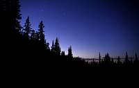
Northern Sawatch Overview
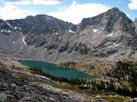
When most people think of the Sawatch Range, they have images of gentle high summits of talus and tundra, well visible from the US 24/285 corridor between Leadville and Salida. To some, these peaks may even be considered devoid of true mountaineering opportunities as the peaks are mainly "walk up" routes. There are a few hidden gems for the mountaineer, but for those whose focus lies with the state's "Fourteeners", these challenges are usually left hidden. The range in someways gets a bit of a bad rap for being "boring", but those who know its secrets also know that statement could not be farther from the truth.One of those special secrets is the Northern Sawatch Range, a bit of an anomaly to the character of the rest of the range. The peaks here are much more rugged, more remote. They are less visible from roads, and less traveled. The trails are rough, lush, and speckled with beautiful lakes and waterfalls. There are a few popular trails, and of course the lone fourteener, Mount of The Holy Cross, creates a lot of attention, but much of the rugged beauty of this place will require you to "work for it". That is precisely what makes it so special, and hopefully this page and the mountain pages associated with it, will help give you a taste of the adventures and beauty that await those willing to put in the work to explore deeper.
The Northern Sawatch Range primarily falls under the US Department of Agriculture as National Forest. The area primarily falls in the White River National Forest, but parts also lie within the San Isabel National Forest. There are also areas of Colorado State Lands, and some Bureau of Land Management (BLM) land as well.
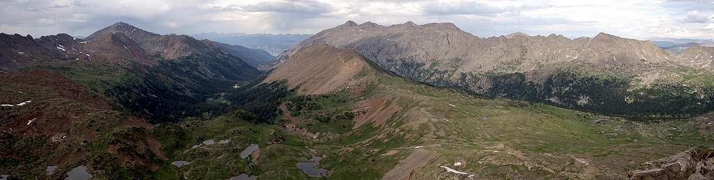
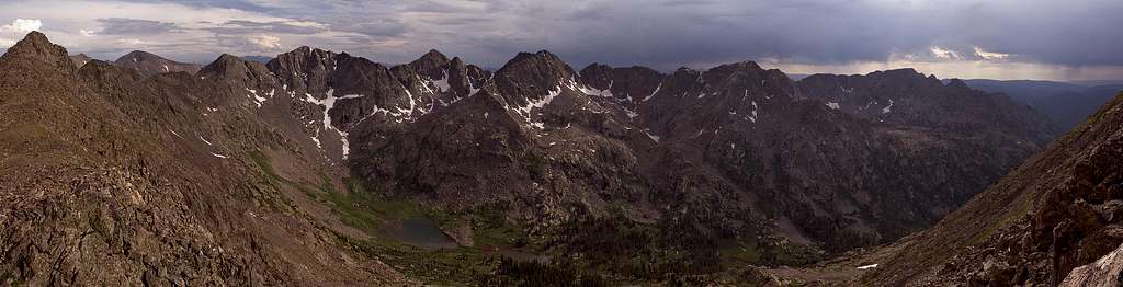
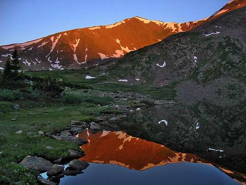
IMPRESSIVE BIG VERSION
Geographically, it is often hard to find the best place to draw the line between mountain ranges. I tend to use geographic divisions such as rivers or mountain passes. For the purposes of this page, I am going to use Hagerman Pass and the Fryingpan River to divide the Northern Sawatch from the rest of the range, but will make some mention of the Hunter-Fryingpan Wilderness as that area is more in character with the peaks to their north. Using Hagerman Pass also makes sense because it is the northernmost place where one can drive on a road to cross the range.
Completing the boundaries, starting at Hagerman Pass the range roughly follows the Continental Divide to Tennessee Pass, then follows the Eagle River along US 24 and I-70 to the Colorado River to Glenwood Springs. Going west from Hagerman Pass, the division roughly follows the Fryinpan River to Basalt, then follows the Roaring Fork River to Glenwood Springs. This puts the southern half of Glenwood Canyon in the Sawatch, which some may find debatable, but I think the rivers make a good boundary here as there are not really many other logical choices.
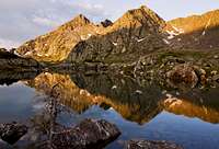
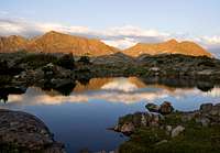
The Northern Sawatch Range offers a seemingly endless array of outdoor activities in a beautiful and remote setting. Hiking is perhaps the best way to experience the range because most of its beauty lies within the boundaries of Holy Cross Wilderness. Additionally there is Sylvan Lake State Park, Ruedi Reservoir, 10th Mountain Division backcountry huts, Jeep Roads (which double for some excellent mountain biking) and Camping from organized campgrounds, dispersed car camping or remote backpacking excursions far from civilization. There is Fishing, Rock Climbing, Skiing and more. If you like lakes, waterfalls and wildflowers, you will be in a sensory overload! This range has so much more to offer than just one fourteener, and is worth coming back to again and again to learn more of its secrets. I have been exploring it for 8 years and still have many places I have never seen. It is truly one of Colorado's special places, and I hope these pages help give you a taste of the beauty you will find when you visit.


Special Areas
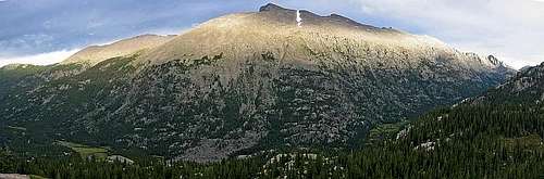
Within the Northern Sawatch Range are several areas that have received special recognition, and if you are new to exploring here, these are great places to start. They include Wilderness and Wilderness Study Areas, a State Park, State Wildlife Areas, Recreation Areas and a nationally renowned ski resort.Holy Cross Wilderness
Established in 1980, Holy Cross Wilderness consists of 122,918 acres of rugged peaks, glacial valleys, and lush creeks. The area is named for its highest peak, Mount of the Holy Cross, which was made famous in 1873 when photographed by William Henry Jackson, who also has a peak named after him. This wilderness area spans parts of 3 counties, Eagle, Lake and Pitkin, with the majority of the acreage in Eagle County and managed through the Holy Cross Ranger district in Minturn, Colorado.
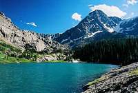
There are over 150 miles of total trails, 50 summits with at least 300 feet of prominence and countless lakes, streams and waterfalls to keep ones attention. Popular activities include hiking, fishing, hunting, backcountry skiing and of course mountain climbing. Mount of the Holy Cross is the most climbed peak in the area, but there are also 3 other peaks in Colorado's highest 200 and 46 total peaks over 12,000 feet.
Popular trails general involve reaching a lake and include Missouri Lakes, Fancy Lake, Timberline Lake and Lake Charles. You will often find people fishing from their shores, or along the approach creeks. Beaver Creek Ski Resort bounds the northeast corner of the Wilderness and through its backcountry gates people often ski Holy Cross Wilderness, probably without even realizing they are there.
Wilderness is defined by the 1964 Wilderness Act "as an area where the earth and its community of life are untrammeled by man" and "generally appears to have been affected primarily by the forces of nature, with the imprint of man's work substantially unnoticeable". To that effect, Wilderness is one of the highest levels of protection and comes with a list of restrictions which can be found here and include limits on group size, where you can camp, and restrict motorized and mechanized vehicles from entering.
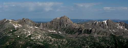
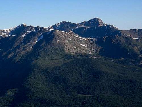
SPECTACULAR BIG VERSION
Hunter-Fryingpan Wilderness
While technically lying south of my above described border, I felt it important to also give a mention to the spectacular Hunter-Fryingpan Wilderness, which is seem much more in character with the Northern Sawatch than most of the rest of the range. Hunter-Fryingpan was established in 1978 and consists of 82,026 acres located generally between Ruedi Reservoir and Colorado State Highway 82 west of the Continental Divide. The area is almost the forgotten gem of the area, with more popular wilderness areas surrounding it seemingly on all sides, no fourteeners, and hardly any named peakss. There are some moderately popular trails accessed from CO 82 west of Independence Pass, but most people just seem to drive right by.
There are over 50 miles of trails and 30 total peaks with 300 feet of prominence, over half of which are taller than 13,000'. Some highlights include some great scrambling opportunities on the Williams Mountain ridge, the Geissler Mountains and a ring of unnamed summits above the Fryingpan River's headwaters. The most popular summit is probably Mount Oklahoma, but most people access it from the east in neighboring Mount Massive Wilderness area as its approach from the west is quite remote. Being a wilderness area, Hunter-Fryingpan has many of the same regulations as Holy Cross, but with some variations. For a complete list click here.
Sylvan Lake State Park
Sylvan Lake State Park is located south of the town of Eagle off of I-70 between Vail and Glenwood Springs. The park offers a variety of activities spread out along both east and west Brush Creeks. Fishing, camping and non-motorized boating are the highlights here. There are also rental Yurts (seasonal) and Cabins that can be rented year round that provide access to snowshoeing, backcountry skiing and ice fishing or can act as a base camp for snowmobiling over nearby Crooked Creek Pass. You can even rent boats if you don't have you own. Sylvan Lake State Park requires a $7 daily permit, or a State Parks Pass ($70/yr).
Turquoise Lake Recreation Area
Turquoise Lake is located west of Leadville near the Hagerman Pass Road and offers 1800 surface areas of boating and fishing with numerous campgrounds surrounding its tree-lined shores. At the west end of the lake, he Continental Divide and Colorado Trails pass through and the Timberline Lake trail in Holy Cross Wilderness shares a trailhead with them. While the lake may be beautiful to look at, it is not without its own controversy. The lake was created as part of the Fryingpan-Arkansas diversion project and provides water for the front range cities east of the mountains. In winter the road around the lake is closed, but there are two backcountry huts within the 10th Mountain Division Hut System - Uncle Bud's and Skinner hut.
Additional Areas
Ruedi Reservoir east of Basalt provides boating, camping, fishing and picnic opportunities and can be quite popular in the summer. Gypsum Ponds State Wildlife Area east of Gypsum along I-70 is popular for fishing and bird-watching. The 4800 acre Basalt State Wildlife Area provides fishing access, a shooting range, and acres of land for hunting in the fall. The small Coke Ovens State Wildlife Area offers opportunities for hunting and wildlife viewing.
Red Table Mountain Wilderness Study Area lies west of Crooked Creek Pass and provides hiking along its long gentle ridges with spectacular views to the southwest of Colorado's Elk Mountains. Red Table Mountain just cracks the 12,000 foot mark at 12,037' and has over 2000' of prominence. The ridge is nearly 20 miles long.
Access
There are three main access roads that lead to the various secondary roads that will get you into the trailheads. US Interstate 70 (I-70), US Highway 24 (US 24) and Colorado State Highway 82 (CO 82). Most people will use I-70 at some point even to access the other two major roads, but depending on where you live will depend on how you get to these major arteries to the mountains. From Denver or Grand Junction or beyond (and most places in between), I-70 will be your first point of access. To reach US 24, you would exit at Minturn (Exit 171) and to reach CO 82 you would exit at Glenwood Springs (Exit 116). US 24 also runs from Colorado Springs in a serpentine fashion generally westward to just south of Buena Vista, where it turns north and runs through Leadville to I-70 in Minturn. US 24 occasionally will require you to turn, pay attention to the signs to make sure you stay on US 24. CO-82 runs from Aspen to US-24 east of Twin Lakes (south of Leadville) via Independence Pass (which is closed in winter).I will describe the major trailheads from each access point, hopefully with pretty accurate directions. I will also include a list of the specific areas you can access from each trailhead including trails, peaks, lakes, waterfalls, and other points of interest.


I-70 Access
Beaver Creek Trailhead (appx 8150' above sea level): Exit I-70 at Avon (167) and navigate around the roundabouts on Avon Road to the Beaver Creek Village entrance gate. Follow the village road up to the parking structures in the village, free in summer, but upwards of $20/day during ski season. During ski season it is best to head west on US 6 to the traffic light and free shuttle parking. Beaver Creek Village trailhead provides access to the Beaver Lake Trail, Holy Cross Wilderness, and Mt. Jackson. Beaver Creek also has many mountain biking and hiking trails on its slopes in the summer.
West Lake Creek Trailhead (appx 8250' 2WD or 9600' 4WD): Exit I-70 at Edwards (163) and navigate around the roundabouts on Edwards Access Road to a traffic light at US 6. Head west for about a mile and take a left (south) on Lake Creek Road. There is a jog in the road (signed) where you will turn right. The road turns to dirt, and then a short distance after there is a large parking lot at the base of the jeep road. The jeep road beyond is not too rough, but it is narrow and can be muddy and requires at least a stock 4x4 SUV to proceed. West Lake Creek trailhead provides access to Holy Cross Wilderness and New York Mountain. In winter the 2WD trailhead is plowed and provides access to Polar Star Inn, a 10th Mountain Division winter hut.
East Brush Creek Road and Trailheads (elevation varies): Exit I-70 at Eagle (147) and head south on Eby Creek Road to a roundabout at US 6. Head west following signs for Sylvan Lake State Park to a roundabout at Brush Creek Road and follow Brush Creek Road (one right turn, signed) for appx 10 miles to the visitor center. A short distance later the road splits, both forks are dirt but passable for passenger cars unless muddy. The left fork is East Brush Creek Road. The road dead-ends in about 7 miles at the trailead for Lake Charles and Fulford Cave which provides access to Holy Cross Wilderness, Lake Charles, Mystic Island Lake, Fools Peak, Gold Dust Peak the Iron Edge trail and Fulford Cave (currently closed). This trailhead is at about 9400'.
About a mile before the end of the road, another dirt road (FS 418) heads up to the town of Fulford. After 3.6 miles you will pass the trailhead for Nolan Lake (appx 9900') and the town of Fulford. If you keep going on the 418 road, you can reach the upper Fulford Tralhead at appx 11,200' which provides access to Holy Cross Wilderness, New York Mtn, New York Lake, Gold Dust and Finnegan Peaks. The road is relentless to this upper trailhead, lots of switchbacks, and a small marked trailhead where you can park. There are several side roads, but the main road is not difficult to follow. It can be rough in places, and probably is not a good idea in a 2WD passenger car, you can probably get a Subaru Outback up it though.
West Brush Creek Road and Trailheads (elevation varies): Exit I-70 at Eagle (147) and head south on Eby Creek Road to a roundabout at US 6. Head west following signs for Sylvan Lake State Park to a roundabout at Brush Creek Road and follow Brush Creek Road (one right turn, signed) for appx 10 miles to the visitor center. A short distance later the road splits, both forks are dirt but passable for passenger cars unless muddy. The right fork is West Brush Creek Road. After 5 miles you will reach Sylvan Lake and the end of winter maintenance. Continue on the Crooked Creek Pass Road around the left side of the lake. The road can be rough in a few places, but generally passable to most vehicles when dry. I recommend at least an AWD vehicle. The pass is about 4 miles about the lake at an elevation of 9995'. The road is FS 400.
Just over the south side of the pass (through a cattle guard), take a right to reach the Mt Thomas/Red Table Mountain Trail (4WD) which provides access to both of those peaks. Further over the pass, the road splits below Crooked Creek Reservoir, the left fork (FS 506) heads to Lime Creek. After a quarter mile take another left to the parking area for the Woods Lake and Lime Creek trails. Woods Lake is private, but a good trail goes around it to provide access to Holy Cross Wilderness, Eagle Lake, Strawberry Lake, Fools Peak, Avalanche Peak, "Ribbed Peak" and several other unnamed 12ers on the Lime Creek Trail. The Woods Lake trail is across the road and heads to Tellurium Lake. The 506 road provides a windy and rough access to Fryingpan Road, its better to back track...
At the 400/506 split below Crooked Creek Pass, taking a right and continuing on FS 400 will lead down hill and through several switchbacks to merge with the Fryingpan Road east of Ruedi Reservoir. This road is in better shape the 506 road and the better choice. See the Fryingpan Road section below under CO 82 Access for the multitude of access points available from this road.
US-24 Access
Grouse Creek Trailhead (appx 8000'): The Grouse Creek trailhead is located directly west of US-24 about a mile and half south of I-70 just before you get to Minturn. The trailhead is a large dirt parking lot off the side of the road and is well signed with a gate marking the start of the hiking trail. You can access the East and West Grouse Creek trails, Grouse Lake, Olsen Lake and Grouse Mtn from this trailhead.
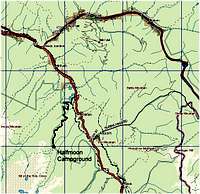
Tigiwon Road and Trailheads (elevation varies): The Tigiwon Road is reached south of Minturn just before US-24 begins climbing over Battle Mountain approximately 5 miles south of I-70. The road is well signed on the right (west) side of the road and is graded dirt the entire way, suitable for most all vehicles when dry. The road is not maintained in winter, and is closed annually from May 1 to June 20 for elk calving. The first trailhead you reach is for Cross Creek, about 1.7 miles from US 24 on the right side at about 8500'. Continuing on the Tigiwon Road you will pass the Tigiwon Community House and campground. At the end of the road, 8.5 miles from US-24 at 10,320' you will reach the Halfmoon Campground and the trailheads for the Halfmoon Trail and Fall Creek Trail. These are the two main access points for the 14er Mount of the Holy Cross as well as the Notch Mountain Shelter, Lake Constantine, Tuhare Lakes and Fall Creek Pass.
Homestake Road and Trailheads (elevation varies): The Homestake Road is located about 13 miles south of I-70 on the right side just before the road makes a switchback and is well signed. There are several trailheads and points of interest along the this road, the first of which you will pass is the Whitney Lake Trailhead at 4.6 miles on the right. The trailhead is marked, but can be difficult to see if you are not paying attention. The trail leads to Whitney Lake and can be used to climb Whitney Peak. 8 miles of US 24 you will pass the base of the Holy Cross City Jeep Road, one of the most difficult off road adventures in the state and not suitable for stock vehicles. On you left around this point is the Gold Park campground.
At the 8.5 mile mark from US-24, the FS 704 road heads right. At about 2.3 miles this road will "T" at a parking area for the Missouri Lakes and Fancy Lake trailheads, these two trails can be combined into a nice loop over their namesake passes and can be used to access several rugged peaks, most of which are unnamed, including Savage Peak. Going left at these trailheads a rough 4x4 road (but suitable for stock SUVs) leads to parking at its end for the Brady and Sopris Lake trails. Taking a right at the Missouri and Fancy Lake trailheads leads you back to a "T" where it meets the Holy Cross City Jeep Trail. Hike up the Holy Cross City Jeep Road to Holy Cross City or the French Creek Trailhead (11,120') which you can use to hike to Seven Sisters Lakes and the south side of Fall Creek Pass. This trail can be used to access the highpoints of Holy Cross Ridge that are south of Mount of the Holy Cross as well as Whitney Peak.
Back on the main road, the Homestake Road ends at Homestake Reservoir and the trailhead for Lonesome Lake. This point is approximately 10.5 miles from US-24. You can also access Homestake Peak from this trail.
Tennessee Pass (10,424'): US-24 crosses the Continental Divide heading from Eagle to Lake Counties at Tennessee Pass, a trailhead on the right provides access to the Colorado Trail, Continental Divide Cabin and Tennessee Pass cookhouse. This trailhead is 22.5 miles south of I-70 or 9 miles north of Leadville.
Slide Lake Trailhead (appx 10,600'): South of Tennessee Pass by not even a mile to the Websters Gravel Pit Road (Lake County 19), turn right and follow for about 1.5 miles to the turn for FS 145, turn right and park at about 1/2 mile at a gate where the road heads over the Continental Divide as the Wurts Ditch Road. The Slide Lake Road is gated and not open to vehicles. You can hike it to Slide Lake, Homestake Peak and the 10th Mountain Hut.
Turquoise Lake Recreation Area (elevation varies): There are numerous ways to reach Turquoise Lake, from the north the best route is to turn right just south of the trailer parks on County Road 99 (signed for Grand Lake Villas), after about a mile the road bends left and drops down a short steep hill. At the bottom of the hill across from a large parking area, turn right on County Road 9 to reach Turquoise Lake. From the south, the best way to access the Lake is at the south of end of Leadvile via McWethy Drive, at a 3-way fork, take the right fork.
Turquoise Lake Recreation Area is surrounded by campgrounds, picnic areas and trailheads. For mountaineers, the most likely objective is all the way at the west end of the lake at the Timberline Lake trail. You can hike to Timberline Lake and several unnamed 12,000' mountains, or pick up the Colorado Trail north towards Galena Mountain. Turquoise Lake is also close to Skinner, Uncle Buds and Betty Bear huts, part of the 10th Mountain Division hut system.
On the south side of the lake, the 4WD Hagerman Pass Road provides access to Hagerman Pass, on the west side of which is the Lyle Lake Trailhead. Continuing west on this road (now 2WD gravel) you can reach access points described below as part of the CO-82 trailheads along the Fryingpan River. This road ultimately will arrive in Basalt where it meets CO-82.
Hagerman Pass for the purposes of this page, is the southern boundary of the Northern Sawatch Range. However, US-24 provides access to many more peaks between Leadville and Buena Vista, see the main Sawatch Range page for these opportunities.
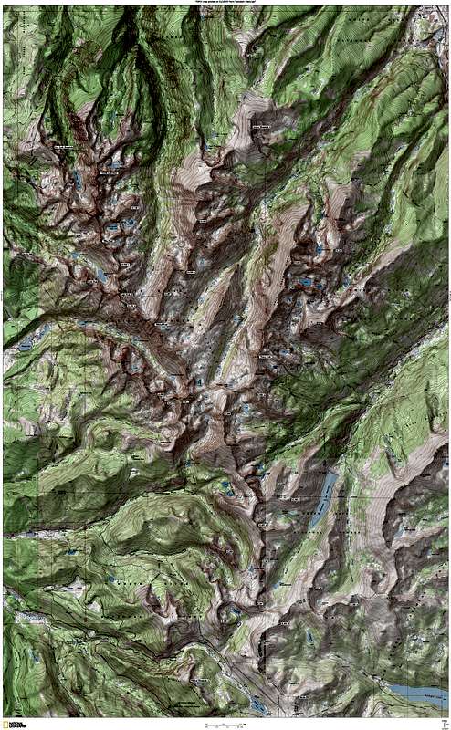
MAPS


Click image for TOPO level 5 detail. You may have to expand the image. This is a huge map.
Red Tape
Camping and Lodging
Peaks & Routes Overview
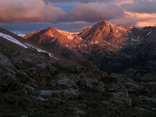
A choice of approaches from the north and south offer a chance of solitude in this southernmost range of the Northern Sawatch.

Easy Class 1 climb accessed from Fall Creek or Seven Sisters area. Accessed from Tigiwon or Homestake Valley roads.

Fall Creek drainage, accessed from Tigiwon Road or over Fall Creek Pass from the Homestake Valley road. Great camping. Trail gets soggy above the lake and below the pass.


History & Controversy
External Links
- Colorado Fourteener Initiative
Reducing Impacts on the Holy Cross Wilderness
- Colorado Springs Exploits Resources
Short article on growing trends against exploitation of Pikes Peak and Holy Cross Wilderness
- Holy Cross Wilderness Area
Quick overview of facts about Colorado's controversial wilderness.
- Angelica couloir
- Mount of the Holy Cross, Holy Cross Ridge, Halo Ridge
- Mount of the Holy Cross and Holy Cross Ridge
- Cross Couloir (07/02/2004)
- A tough one, but worth it
- 14ers.com - The Home of Colorado's Highest Peaks
Fourteener Photos, Route Descriptions, Forum, and more...