
|
|
Mountain/Rock |
|---|---|
|
|
39.48530°N / 106.5367°W |
|
|
Eagle |
|
|
Hiking, Scrambling |
|
|
Summer, Fall |
|
|
13670 ft / 4167 m |
|
|
Overview
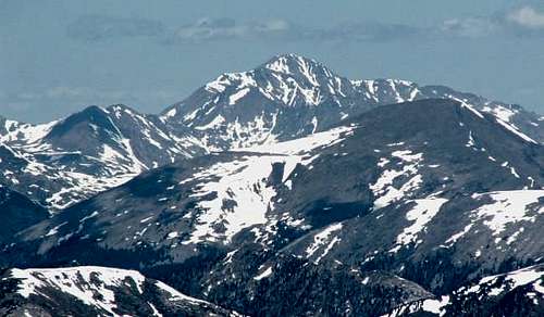
Other than the peaks along the Holy Cross Ridge, Mount Jackson is the highest point in the northern Sawatch range and the Holy Cross Wilderness. From a distance, it stands out as the second most prominent peak in that area, second only to the Mount of the Holy Cross. How it missed the top 100 list of Colorado's most prominent peaks, I wouldn't know. Mount Jackson anchors the longest finger of the five-fingered northern Sawatch Range. It has a pleasing, photogenic appeal from many different angles. Mount Jackson, summer 2006
Statistically, Mount Jackson ranks #101 on the prominence list, and #163 on the elevation list in Colorado. Its "parent peak", Mount of the Holy Cross, is 3.2 miles to the east, separated by Cross Creek. To the west are the stupendous Gold Dust peaks..
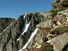
 Peering into the Holy Cross Wilderness from the south
Mount Jackson was named for William Henry Jackson, the famous photographer of the Hayden party who first photographed the Mount of the Holy Cross in 1873. His fabled photographs of the cross couloir made quite a sensation with his contemporaries, and drew many poeple to this area on a religious pilgrimage.
Getting There
Getting to Mount Jackson is your first issue because there is no close-in access. That is probably the main reason that Mount Jackson is so infrequently visited. If Mount Jackson is your main destination, here are the three most reasonable trails. Beaver Creek
Grouse Creek: After exiting Interstate 70 onto U.S. Highway 24, drive 1 mile south to the trailhead across from Meadow Mountain Business Park. The elevation is 7850'. This trail also provides access to Jackson's northeast ridge, and allows you to climb Grouse Mountain as well, without going much out of your way. This approach is slightly longer than the Beaver Creek approach.
Cross Creek: The trail starts from an area just off of highway 24 south of Minturn. The trailhead is at 8000' elevation. Take exit 171 from I-70, and follow highway 24 south for 4 miles to Tigiwon Road FDR 707. Follow Tigiwon Road 2 miles to the trailhead on the right. This trail provides access to couloirs on Mount Jackson's east side.
Red Tape
Mount Jackson is in the White River National Forest and Holy Cross Wilderness Area. No motorized vehicles are allowed. Dogs must be on a leash so as not to disturb the wildlife. Do not camp within 100 feet of lakes, creeks, or trails. The Holy Cross Ranger District has jurisdiction. over the northern Sawatch Mountain Range and the western flank of the Gore Range. It includes the forest areas surrounding the towns of Vail, Minturn, Red Cliff and Avon.The Beaver Creek Hiking Center is a business that exists to lead tours and make money, but they also might provide you with useful information if you ask. See their link below.
Holy Cross Ranger District
24747 US HWY 24
P.O. Box 190
Minturn, CO, 81645
Phone: 970-827-5715
Parking at the Beaver Creek Resort is free during the summer, but be sure of two things. First, pick up a pass at the guard station as you enter. I was told they are on duty 24 hours a day. And second, make sure you park in a public area. The signage is small in some cases, and nothing would be worse than coming back from an overnight backpacking trip to find that your vehicle had been towed away from a private parking space!
Camping
Camping is not permitted at Beaver Lake, although the lake is located just inside the wilderness boundary. Nor would you want to camp in the ski area below the lake. The best potential camp sites are located 1 to 1.5 miles above Beaver Lake, and farther up, near the lower Turqoise Lake.External Links
NOAA National Weather Service point forecast for 12,000', Mount Jackson.The Town of Minturn website offers good information on trail access, including the trails mentioned above.
Climber.org June 2000 Mt Jackson trip report - Cross Creek and east couloirs
White River National Forest
Holy Cross Wilderness Area
Biography of William Henry Jackson.
Online bibliography of William Henry Jackson.
Beaver Creek Hiking Center
Beaver Creek Resorts
Views from Mount Jackson
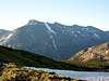
 East Lake Ck basin
The northen Sawatch Range consists of several fingers spreading outward and northward, like a person's hand. This view looks at the junction of the Mount Jackson finger and the next one to the west. The East Lake Creek drains this area.
 Holy Cross Ridge
The Holy Cross Ridge anchors the next finger to the east of Mount Jackson. It comes into view abruptly as you pop up on the saddle of Jackson's northeast ridge. It's a different view of Holy Cross, and quite a scene.
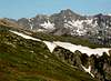
 Pika and Gold Dust
Pika Peak (left) and Gold Dust Peak (right) dominate the view to the west of Mount Jackson. Notice the stairstep, three alpine lakes, and Mount Sopris in the distance.
 North Gold Dust
Actually I don't think this peak has a name but "North Gold Dust" makes perfect sense since that's where it is... just north of Gold Dust Peak. Scenery doesn't get much better than this!
 Jackson east side
A look over the edge at some of Jackson's east side couloirs.