
|
|
Mountain/Rock |
|---|---|
|
|
39.36750°N / 106.4148°W |
|
|
Lake/Eagle |
|
|
Hiking, Scrambling, Skiing |
|
|
Spring, Summer, Fall, Winter |
|
|
13209 ft / 4026 m |
|
|
Overview
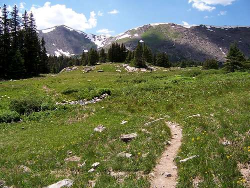 Homestake Peak & the upper basin
Homestake Peak sits at the far northern reaches of the Sawatch Range in Central Colorado. It is 6.9 miles southeast of Mount of the Holy Cross and 6.83 miles southeast of Holy Cross Ridge, its nearest high neighbor. Homestake Peak sits on the Continetal Divide and straddles the county lines of Lake and Eagle county. It is located in the White River National Forest.
The mountain for the most part is fairly isolated. Homestake Reservoir lies roughly .5 mile WSW and 2,942 below. Slide Lake and the 10th Mountain Memorial Hut lie .4 mile northeast and 1,483 feet below. There are no trails or climbers trails leading to the summit.

Slide Lake
Homestake Peak has a broad east shoulder which provides easy access to the summit. However, to gain access to this sholder one must cross the lower meadow, muliple stream crossings and wetlands. As an alternative, there is a shorter albeit steeper shoulder just to the south of Slide Lake (or north or Homestake Peak). This particular route provides quicker and easier (less muddy & wet) access and will deposit you onto the north ridge between Point 12,635 and Homestake Peak. From here, the summit is only .3 mile south. The area around the lake and the jeep trail is class I. From the lake to the actual summit, the terrain turns to class II, grade I.
The 10th Mountain Memorial Hut and Slide Lake lie in an elevated area flanked by Homestake Peak and its' long north ridge to the west and dense forest directly to the east. In the Summer time, there is an orchestra of colour from the multitudes of wildflowers and plants. In the Winter, this becomes a lonely place, visited only by cross-country skiers and the occasional snowshoer. Because of this, deer are often sighted here and on occasion I have seen an Elk or two. Pika and Marmot call the ridge and northern flanks home so their barks will probably be the only thing you hear. Because of the copious amounts of water in this area, Mosquitoes are usually a problem. Repellent would be a very good idea.
Roundtrip time from Slide lake to the summit will only set you back 3-5 hours.

Picture of the summit
The summit offers views of Turquoise Lake and Leadville to the south, Homestake Reservoir, Mount of the Holy Cross and the Elk Mountain Range all in a westerly direction, the Gore Range to the north and Ski Cooper to the northeast. This peak would make for a good Winter climb as long as you stay to the East Shoulder; there is a good reason why locals call it 'Slide Lake"!
Clean Prominance: 1,459ft. (445m) Holy Cross Ridge
Homestake Peak: 13,209ft. 39*22.055 N -106*24.875 W
Slide Lake: 11,726ft. 39*22.394 N -106*23.732 W
Getting There
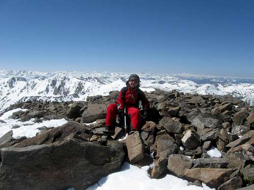
Kessler sitting atop Homestake Peak! -SP member, Scott
From the western side, that is near Homestake Reservoir, there are NO trails leading to the summit or its' southern ridge. If one choose to do this, it would encompass all "bush-whacking" off-trail hiking. However, treeline from this vantage is only 150-200 feet. After that, it turns into a scree slope to the ridge and non-descript summit. For access on this particular route see below in section 6 (Homestake Road/Reservoir). Since this is not the standard route to the summit, I mention it only.
To access Slide Lake (eastern side):
From the small railroad town of Minturn, two miles southwest of Vail, travel south on US-24 for 23.1 miles to Websters Gravel Pit Road (also known as Lake Cty. 19). This road though not signed as such is 'technically' known as Meadow Drive on zoning quads. If you're approaching from the south, leave Leadville and travel north on US-24 for approximately 9.5 miles.
The dirt road is marked by a wooden slate sign sitting atop of a piece of old farm machinery saying, "Websters Gravel Pit", a few mailboxes and a blue County Road 19 sign. There is also a small parking area here for Winter access for cross-country skiers and snowshoers. The Colorado Trail passes close to this area.

Topo #2
From this junction, follow Websters Gravel Pit Road (CR-19) for about 1.45 miles to the junction with Forest Road 145.
Turn right (west) at this point and drive an additional .4-.5 mile to an old Ranger Cabin. There is ample place to park here if you are driving a car or if the gate is closed. This is also where Wurst's Ditch Road begins and an old hiking trail called Mitchell Creek Trail which connects with the Colorado Trail further back down Forest Road 145 that you just drove up. This trail is popular with mountain bikers and in the Winter, cross country skiers. FR 145 beyond this point is rough and slow going. DO NOT TAKE A CAR PAST THE GATE. Even though the road is not 'technically' difficult (for an off-road vehicle), it is extremely rough. Slide Lake is only another 3.8 miles up this Jeep Trail. From US-24, Slide Lake is roughly 5.8 miles.
Red Tape
There is private property on CR-19 (Websters Gravel Pit Road) for the first half-mile. Aside that everything else is National Forest. Regular fire hazards and restrictions apply.
Websters Gravel pit is also private property. Please respect.
Come summer, expect big dumpers, backhoes and heavy truck traffic on the lower portions of the road.
Camping
Camping is not allowed along the main road because of the private property. Even the empty field and forest you pass through is zoned for residential use. Once you turn onto Forest Road 145, pitch your tent where ever you want! Just remember to follow the water regulations.
The 10th Mountain Hut system is a viable option to utilize. At Slide Lake, that particular hut is called the 10th Mountain Memorial Hut. It contains all the pots and pans you'll need, a wood burning fireplace and a wood stove and has an awesome deck! 10th Mountain Hut System

Click for weather forecast
External Links
This is a cool link of local virtual Earth for the area:Virtual Earth
Sawatch Peaks over 13,000ft: 13,000+
Homestake Reservoir & Road

Homestake Valley
Homestake Road (FR 703) is about 11.5 miles long and navigates up the canyon for which it is named. The road ends at the reservoir. The elevation of the reservoir is 10,267ft.
From Minturn, travel south on US-24 for 7 miles to FR 703. Turn right and continue for an additional 11 miles.
Along this road there are ample places to pull over and fish, some spots being espacially good. I believe mainly Brookies, Brown and the occasional Cutthroat occupy the stream. Blodgett Campground and Gold Park Campground (5.7 miles) are exceptional. You can also access Missouri Creek Road, Whitney Lake, Honkey Dorey Lakes, Notch Mountain and the ghost town of Holy Cross City from this road, all within 7.5 miles from US-24. The Jeep Trail leading up to Holy Cross City is a SERIOUS 4x4 road. I would not undertake it in a stock vehicle.
From Homestake Reservoir, there is a partial view of Homestake Peak. But from this angle, it appears to be nothing more then a minor high point along a very non-descript scree covered ridge. There is also good fishing from the banks of the reservoir. A small parking area exists that would accommodate 8-12 vehicles.