
-
 4514 Hits
-
 78.27% Score
-
 9 Votes
|
|
Mountain/Rock |
|---|---|
|
|
38.95970°N / 106.428°W |
|
|
Mountaineering |
|
|
Spring, Summer, Fall, Winter |
|
|
13462 ft / 4103 m |
|
|
Overview

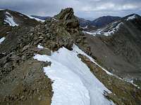
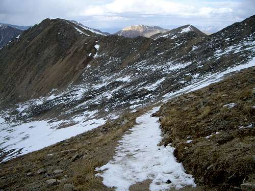
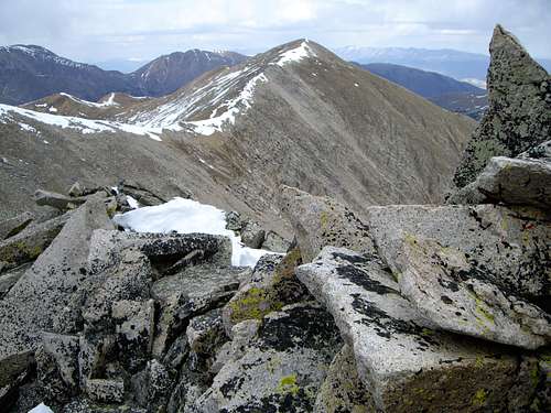
This unnamed peak lies quietly northeast of the popular Colorado 14er Huron Peak (14,003ft) in the Sawatch Range. The Sawatch Range is an 80 mile long subrange of the Colorado Rockies. These peaks are characterized by steep, gentle slopes and offer very few technical routes or scrambles. Nevertheless, they do offer countless miles of Class 2 hiking at high altitudes. Point 13,462ft. is rarely climbed. You are likely to have the summit to yourself. This is opposed to it's popular neighbors; Huron and Browns Peak. The mountain is known as a tri-centennial - meaning that it is one of Colorado's 300 highest peaks ranking at #279. Point 13,462ft lies within Chaffee County and the San Isabel National Forest. The summit offers an awesome vantage point, surrounded by a sea of high peaks. For those who do seek a nice hike in Colorado's high country, this is a fantastic choice. It also offers a great training climb for the aspiring peak bagger. Point 13,462 lies approximately one mile of Huron and is an extension of the 14ers north ridge. You will likely see others along the Huron Peak trail but once you leave the trail from the Browns Pk.-Huron saddle solititude will be yours.
Route Overviews:
Via South Winfield Trailhead:
The standard way to climb Point 13,462 is to use the South Winfield TH at 10,600ft (read "getting there" for detailed directions). The 2WD TH is at 10,260ft. and will add 2 miles of distance (each way) on your ascent. From the South Winfield TH at 10,600ft. the climb is approximately 9 miles roundtrip with 2,862ft. of elevation gain. The route is all Class 2 hiking. Begin by hiking up the Huron Peak trail all the way to the Browns-Huron saddle. The ridge on Browns Peak is littered with talus boulders that require careful, mindful footwork. The elevation gain noted above does not include the 183ft. drop and rise of climbing Browns Peak in route. You can bypass Browns Peak and save some elevation loss & gain by skirting Browns Peak on it's southeast slopes. These same southeast slopes could have significant avalanche danger in winter & spring.
Via Rockdale Trailhead:
This TH is at 9,950ft. To get there, take US24 to Chaffee County 390, go west down the nice dirt road about 9 3/4 miles to Rockdale. Take a south turn (left) at the collection of cabins known as Rockdale. This is the 2WD TH. If you have a 4WD you can go all the way to Clohesy Lake at 10,968ft. From just below the lake, you can ascend Point 13468's steep East slopes. This approach is seldom used and has a more wild, rugged feel to it. The elevation gain is 3,583ft. from the 2WD parking at Rockdale. Distance not available (?)
Getting There
A good dirt road provides access to this beautiful landscape. Chaffee County 390 is approximately 16 miles north of Buena Vista, CO along US24. Once you make the west turn continue down the nice dirt road and pass Rockdale which is nothing more than a few old cabins on your left side. Follow the road to Winfield at 11 and a half miles. Low-clearance vehicles should park here, a sign warns that the road becomes much rougher. 4WD vehicles can continue down the road an additional 2 miles to the Huron Peak trailhead at 10,600ft. The last two miles of road after Winfield are pretty rough and would be impossible for a regular car. The road has no exposure, just large boulders and dips. From this trailhead there are a variety of ways to climb Point 13,462ft.
During a winter season of high snowpack conditions, it may be necessary to snow mobile down Chaffee County 390 to make the length of the climb feasible.
Red Tape
This ranked Colorado "13er" has no red tape at this time and is free for all to enjoy. The visitor must comply with National Forest regulations and is advised to stay on route to avoid the effects of trail braiding. Leave no trash and leave no trace.Camping
There are many informal campsites along Chaffee County 390 once you leave US24. Be mindful with your food because this area does have Black Bears. From the South Winfield trailhead, one could do a short backpack to treeline. A backpack isn't required for this short ascent and the terrain is very steep in most areas. When it isn't thunderstorm season, one could also camp above treeline in the bowl between Browns Peak and Huron Peak.External Links
If your going to attempt a winter ascent I'd recommend stopping by the Colorado Avalanche Information Center website. It's an invaluable resource!!Or, for a weather forecast of the area:
www.weather.com
The nearest town is Buena Vista, CO and a weather forecast for this charming town will give an idea of what weather may be like on the peak. As is to be expected, the higher you climb the windier and colder it becomes.
jfrishmanIII - Nov 12, 2007 12:24 am - Hasn't voted
CoordinatesJust a heads up, your Lat./Long. is off. You're coordinates place the peak in the Elks, on Treasury Mountain which has an identical elevation. Looks like a cool mountain though!
altitude14er - Nov 12, 2007 12:54 am - Hasn't voted
Fixed.Thanks.
Bob Sihler - Nov 12, 2007 8:47 pm - Voted 10/10
Thanksfor adding that route info. Nice page. I deleted the other comment. By the way, since this is in the additions section, you can delete this yourself if you want to. Thanks again for the nice work.