

|
|
Mountain/Rock |
|---|---|
|
|
38.42300°N / 106.225°W |
|
|
Chaffee and Saguache counties |
|
|
Hiking, Mountaineering, Scrambling |
|
|
13971 ft / 4258 m |
|
|
Overview
The Sawatch Range is home to 29 of Colorado's 100 highest peaks, the 'Centennials' as they are colloquially known. This range, known for its giant, easy rolling mountains features some of the easiest peaks in the state to ascend but with a cavaet, most entail huge elevation gains to reach their gentle summits. Mt. Ouray is certainly no exception.
Mt. Ouray lies at the southern tip of the Sawatch Range. There is one other bulky mountain just a little bit further south, Mt. Antora. But even with its impressive 2409' of rise, the sheer bulk and 2671' of prominancce of Ouray still makes it visible from hwy. 50 and from the town of Salida and Poncha Springs.
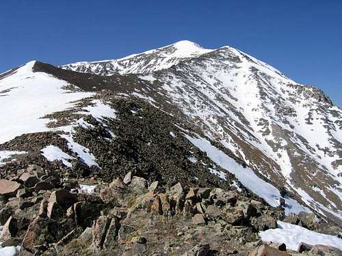
At its hardest, Mt. Ouray is only a class-2 hike and not all that popular. There are several options to scale its gentle summit but the two most commonly used are Marshall Pass (10,482') and Little Cochetopa. The biggest, most defining feature of Mt. Ouray is the eastern flank. There is a HUGE basin that looks like someone used a trowell to scoop that side of the mountain away. Folks call it the, 'Devil's Armchair.' It provides two decent eastern ridges to scramble.
Mt. Ouray was named for the famous Tabequache Ute Chief, Ouray. More than likely due to his uncanny ability to lead people and see solutions and answers to the problems of the day (typically involving white men). Mt. Chipeta which, lies 1.2 miles northwest is named for his trail-blazing wife.
The best times to hike this seemingly unpopular mountain are ing the summer and fall. Marshall Pass is closed in winter so winter ascents are uncommonly rare. The lower forests hold many enclaves of ponderosa pina and quaking aspen. In the fall, the lower forests are awash in hues of yellow and orange.
Mt. Ouray is located in the northern corner of Saguache County. Throughout the decades, it has been known as: Ouray Peak, Hump Mountain and Ouray Mountain. Officially, the USGS recognized this sierra as Ouray Peak as of 1-1-1906. They eventually reconnoitered their naming conventions and as of 1-1-1962, changed the name officislly to Mount Ouray.
Colorado Rank: 58th
Quadrangle: Mount Ouray
Prominance: 2671'
Getting There
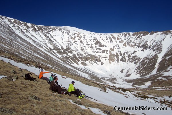
Mount Ouray from Little Cochetopa Trail
Marshall Pass Trailhead is at 10,820' elevation and provides access to the southwest side of Mount Ouray. Drive 5.3 miles south from Poncha Springs and turn west onto Marshall Pass Road (FS 200). Measuring from this point, reach the trailhead at mile 14.3. With a 4WD vehicle you can drive an additional mile on an old road leading to a mine at 11,400'. There is a restroom at the top of Marshall Pass, just 0.2 miles southwest of the trailhead.
Grays Creek Trailhead is at 9,660' elevation on the Marshall Pass road. If you are approaching from the north, go 5.3 miles south on Colorado 285 toward Poncha Pass form the junction of 285 and U.S 50 in the town of Poncha Springs. Turn right at the well-signed Marshall Pass road. This road is an improved dirt road and should not be a problem for passenger cars. Continue on the road for 2.4 miles and turn right on to FS 202. Continue on 202 for 0.8 miles and turn right at a four way stop. Continue another 4.2 miles to the Grays Creek pull-off on the right. There is no trailhead sign, just a "Grays Creek" sign.
Little Cochetopa Trailhead, at 10,300' elevation, provides access to Mount Ouray's north side. Turn onto County Road 210, two miles west of Poncha Springs. Drive 5 miles south and west to Cochetopa Wildlife Management Area. The road is not maintained past that point and the last three miles to trailhead are rough, requiring a high clearance vehicle. If so equipped, drive the remaining 3 miles to the end of the road and the beginning of the trail.
Red Tape

Mt. Ouray is located in the San Isabel National Forest and lies less than a mile east of the Continental Divide. Since it is national forest, the rules and regulations are laxed and even non-existent. Because of this, just use your common sense in situations. Engage in good stewardship practices like: Leave no trace, Stay the Trail, no fireworks, unattended campfires, watch your domesticated animal and such.
Enjoy the wilderness and leave it for others to enjoy in the future!
When to Climb
The best times to hike this mountain are in the summer and fall. Marshall Pass Road is open for most of the year. It connects US. 285 to the small town of Sargents/Tomichi Creek on US. 50. This dirt forest service road has an average grade of 4% with 7% near the top of the pass. It is passable for passanger vehicles with some careful driving.
Since the road is closed in winter, cross country skis, snowmobile and snowshoes are necessary to access the backcountry. Just keep in mind, doing so, you'll be far from your vehicle and help if an emergency occurs. Winter guarantees almost 100% privacy and solitude. And with the road, access is fairly easy.
Summer and fall of course, make things easier with idyll weather, longer daylight and such.
Camping
There are several options to camp in the vicinity including an old ranchers cabin located near the top of the pass. All are great choices.
- O'Haver Campground/Lakes- This is an increably great campground and one that I have used a few times. O'Haver functions on a first-come, first-serve basis. The lake there is stunning and provides for some decent fishing, boating and localized hiking. Located at 9,200', the surrounding ponderosa pine and aspen is thick. There are 31 sites at this location and it is exceptionally popular and busy on summer weekends, so plan accordingly. There are vault toilets, trash collection, potable water and during ther summer months, a campground host.
| Grills | Picnic Tables | Metal Fire Rings |
Leveled Tent Pads |
| No RV Hookups | Quiet Hours: 10:00 PM-6:00 AM | Potable Water | Fishing Pier |
From Salida, travel 6 miles west on hwy. 50 to Poncha Springs. At the light/'T' intersection, turn left (south) and drive for 5 more milkes on hwy. 285. Turn right onto
county road #200 and continue for 2.3 miles. Then turn west onto county road #202 and drive for an additional 2.5 miles.
Information: #1.877.444.6777 or #719.539.3591 (Salida Ranger District Office)
- Dispersed Camping- To access spots and clearings that offer dispersed camping (less formal than O'Haver), keep driving up Marshall Pass Road passing the campground. There are sporadic pull-offs aomg Silver Creek. About a quarter mile past the junction, more larger spots will pop up. Of course, there are no amenities doing this, but you'll have a larger degree of privacy and no fees. The maximum stay is 14 days. Some areas do have existing rock fire rings. This is a great alternative.
- Hutchinson-Burnett Cabin- Near the top of the pass on th east side, is a cabin that was built in 1935 by Bailey Hutchinson and Burt Burnett for their cowhands while they worked the herd. The cabin was built from handcut spruce logs that were hauled over Marshall Pass. The cabin, while not in much use anymore as a work-over is available to stay in if vacant. The cabin has a wood burning black iron stove, stacks of firewood against the wall and two metal bedframes with plywood, so make sure to bring your sleeping pad and bag. There is a picnic table out front and a large stump. An informative placard also exists out front detailing the history of the cabin. It's as rustic as you can possibly get but man, it's so cool! N 38°23.803--W 106°14.831
- Angel of Shavano Campground- While this campground is a bit further from county road #200 and Marshall Pass, it does offer additionbal space, flat areas to camp and relative privacy. From Salida, drive west on hwy. 50 for ten miles. Turn right (north) onto county road #240 by the Creekside Chalets & cabins and continue for an additional four miles on a gentle dirt road. It is passable for 2WD vehicles and trailers. There are 20 spots available (all RV and tent compatible) with a vault toilet and picnic tables.
Who was Chief Ouray?
![]() Born in Abiquiu, New Mexico (north of Taos) in Northern New Mexico around November 13, 1833, Ouray was born to a Jicarilla Apache father and Tabeguache mother. This was when Taos and all the territory belonged to Mexico. When they were younger, their mother sent Ouray and his brother, Quenche away to live in Taos to become 'criados,' basically indentured servents to weathly land owners, one of which was a weathy Spanish priest. This would put Ouray in the position to learn multiple languages and be around people of power. Not only did he speak Apache, but Ouray spoke Ute, Spanish and even some English. Ouray grew up to eventually become leader of the Tabeguache Ute in western Colorado. Ouray, whos name means 'Arrow' in Ute, was bestowed the title Chief of all Utes in Colorado by the US Government and bureau of Indian Affairs and made the primary contact for all treaty negotiations even though he spoke little english.
Born in Abiquiu, New Mexico (north of Taos) in Northern New Mexico around November 13, 1833, Ouray was born to a Jicarilla Apache father and Tabeguache mother. This was when Taos and all the territory belonged to Mexico. When they were younger, their mother sent Ouray and his brother, Quenche away to live in Taos to become 'criados,' basically indentured servents to weathly land owners, one of which was a weathy Spanish priest. This would put Ouray in the position to learn multiple languages and be around people of power. Not only did he speak Apache, but Ouray spoke Ute, Spanish and even some English. Ouray grew up to eventually become leader of the Tabeguache Ute in western Colorado. Ouray, whos name means 'Arrow' in Ute, was bestowed the title Chief of all Utes in Colorado by the US Government and bureau of Indian Affairs and made the primary contact for all treaty negotiations even though he spoke little english.
Over Ourays adult life, he negotiated multiple contracts and treaties with the US Government at the detriment of actually losing ancestral lands. On the flipside of that, he probably saved countless Ute lives & soliders lives due to avoidance of war. Today, Ouray County, the town of Ouray and this SP page are named in his honor. The Ute Indian Museum located in south Montrose lies northwest of land that once belonged to Ouray and his wife, Chipeta.
Chipeta (White Singing Bird) was Apache by birth but raised by Ute. She was originally tasked to watch over and care for Ourays first son, Paron (Pahlone). But sometime in 1862, Lakota kidnapped him during a raid and for all intensive purposes, he was never seen again.
Ouray would go on to marry Chipeta after his first wife, Black Mare died of unknown circumstances. Being much younger than Ouray, she was reknown for her beauty, hospitality and skills of negotiation. Chipeta was inducted into the Colorado womens hall of Fame in 1983.
Ouray, because of his language, communication skills and ability to lead people, developed contacts deep within the US Government and Bureau of Indian Affairs that put him into the position (whether he wanted to or not) to be at most of the treaty signings and be the point of contact for the Ute tribes. Many thought Ouray was too easily giving up and laying over for what the US Government wanted, being their lands. This is something he did time and time again. But the argument can be made that if Ouray hadn't done this, losing lands in the process, his people could have just as easily been wiped out in genocide by the US Government in order to acquire the lands they were forced onto. It's plausable he saved many, many lives by seeing the impossibilty of a fruitless situation against a tremendously larger [and occupying] enemy.
I can't do justice to this great man here. This is just a short 'Cliff Notes' version. Colorado Encyclopedia has a good write up on this remarkable man.
The Crestone Eagle Newspaper has an EXCELLENT write up.
A little Marshall Pass History

In 1873, Marshall Pass was discovered during the Wheeler Survey Expedition (1872-76). It is named for the chief military surveyor on that expedition, William Louis Marshall. Marshall would end up going on to lead successful projects ion Vicksburg on the Mississippi, in Wisconsin and he developed new methods involving canal lock construction; so, a smart guy. In 1880, a toll road was constructed over the pass by Otto Mears and the following year, 1881, the railroad followed, a narrow-gauge. At the peak of popularity/commerce, Marshall Pass had six buildings, eleven people and what Time magazine called, "The smallest United States smallest post office." Gus Latham was the Postmaster.
The cowhands greatly benefited from the railroad. The Denver & Rio Grande traveled past the Hutchinson-Burnett cabin. The local ranchers would utilize the cars to transport salt up the grade whereby, the railhands would kick the large chuncks of salt out of the open cars onto the causeway paralleling the rails. Cowhands would then break it up into smaller, more manageable pieces and haul it away to the fields for their cattle. In the fall, ranchers would round up the cattle from multiple herds (based on branding) and drive them back to the pass to be either sold at market or butchered to sustain the familes and employees throughout the winter. The railroad was eventually discontinued and shut down in 1955.
The current road follows the old railroad grade over the pass and down the west side to the small town of Sargents on hwy. 50. The road is roughly 30 miles in length.
The Phantom Trail of Marshall Pass
Soon after the rails were laid across Marshall Pass, Colorado, where they go over a height of twelve thousand feet above the sea, an old engineer named Nelson Edwards was assigned to a train. He had traveled the road with passengers behind him for a couple of months and met with no accident, but one night as he set off for the divide he fancied that the silence was deeper, the canon darker, and the air frostier than usual.
A defective rail and an unsafe bridge had been reported that morning, and he began the long ascent with some misgivings. As he left the first line of snow-sheds he heard a whistle echoing somewhere among the ice and rocks, and at the same time the gong in his cab sounded and he applied the brakes.
The conductor ran up and asked, “What did you stop for?”
“Why did you signal to stop?”
“I gave no signal. Pull her open and light out, for we’ve got to pass No. 19 at the switches, and there’s a wild train climbing behind us.”
Edwards drew the lever, sanded the track, and the heavy train got under way again; but the whistles behind grew nearer, sounding danger-signals, and in turning a curve he looked out and saw a train speeding after him at a rate that must bring it against the rear of his own train if something were not done. He broke into a sweat as he pulled the throttle wide open and lunged into a snow-bank.
The cars lurched, but the snow was flung off and the train went roaring through another shed. Here was where the defective rail had been reported. No matter. A greater danger was pressing behind. The fireman piled on coal until his clothes were wet with perspiration, and fire belched from the smoke- stack. The passengers, too, having been warned of their peril, had dressed themselves and were anxiously watching at the windows, for talk went among them that a mad engineer was driving the train behind.
As Edwards crossed the summit he shut off steam and surrendered his train to the force of gravity. Looking back, he could see by the faint light from new snow that the driving-wheels on the rear engine were bigger than his own, and that a tall figure stood atop of the cars and gestured franticly. At a sharp turn in the track he found the other train but two hundred yards behind, and as he swept around the curve the engineer who was chasing him leaned from his window and laughed. His face was like dough.
Snow was falling and had begun to drift in the hollows, but the trains flew on; bridges shook as they thundered across them; wind screamed in the ears of the passengers; the suspected bridge was reached; Edwards’s heart was in his throat, but he seemed to clear the chasm by a bound. Now the switch was in sight, but No. 19 was not there, and as the brakes were freed the train shot by like a flash. Suddenly a red light appeared ahead, swinging to and fro on the track. As well be run into behind as to crash into an obstacle ahead. He heard the whistle of the pursuing locomotive yelp behind him, yet he reversed the lever and put on brakes, and for a few seconds lived in a hell of dread.
Hearing no sound, now, he glanced back and saw the wild train almost leap upon his own–yet just before it touched it the track seemed to spread, the engine toppled from the bank, the whole train rolled into the canyon and vanished.
Edwards shuddered and listened. No cry of hurt men or hiss of steam came up–nothing but the groan of the wind as it rolled through the black depth. The lantern ahead, too, had disappeared. Now another danger impended, and there was no time to linger, for No. 19 might be on its way ahead if he did not reach the second switch before it moved out. The mad run was resumed and the second switch was reached in time. As Edwards was finishing the run to Green River, which he reached in the morning ahead of schedule, he found written in the frost of his cab-window these words:
“A frate train was recked as yu saw. Now that yu saw it yu will never make another run. The enjine was not ounder control and four sexshun men wor killed. If yu ever run on this road again yu will be recked.”
Edwards quit the road that morning, and returning to Denver found employment on the Union Pacific. No wreck was discovered next day in the canyon where he had seen it, nor has the phantom train been in chase of any engineer who has crossed the divide since that night.
By Charles M. Skinner, 1896. Compiled and edited by Kathy Weiser/Legends of America, updated September 2019.
External Links
- Climb 13ers- Marshall Pass Trailhead
- All Trails- Marshall Pass and Poncha Creek OHV
- 14ers.com- Some info & condition reports from users
- Great trip report from Ben over on 14ers.com
- Ski Trip by GB (14ers.com)
richh - Jul 11, 2022 8:13 pm - Hasn't voted
Chief Ouray typoNice addition to the page. But Chief Ouray was born in 1833.
Kiefer - Jul 13, 2022 2:35 pm - Hasn't voted
Re: Chief Ouray typoThanks Rich. I think I had a case of 'fat fingers' when I typed that up. Good catch.